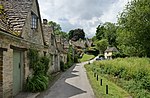
The Cotswolds is a region of central South West England, along a range of rolling hills that rise from the meadows of the upper River Thames to an escarpment above the Severn Valley and the Vale of Evesham. The area is defined by the bedrock of Jurassic limestone that creates a type of grassland habitat that is quarried for the golden-coloured Cotswold stone. It lies across the boundaries of several English counties: mainly Gloucestershire and Oxfordshire, and parts of Wiltshire, Somerset, Worcestershire, and Warwickshire. The highest point is Cleeve Hill at 1,083 ft (330 m), just east of Cheltenham. The predominantly rural landscape contains stone-built villages, towns, stately homes and gardens featuring the local stone.

The Countryside Agency was a statutory body set up in England in 1999 with the task of improving the quality of the rural environment and the lives of those living in it. The agency was dissolved in 2006 and its functions dispersed among other bodies.
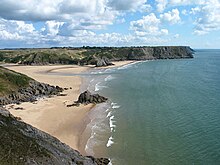
A heritage coast is a strip of coastline in England and Wales, the extent of which is defined by agreement between the relevant statutory national agency and the relevant local authority. Such areas are recognised for their natural beauty, wildlife and heritage and amongst the purposes of definition is support for these qualities and enabling enjoyment of them by the public. For England this national agency is Natural England and for Wales it is Natural Resources Wales.
An environmentally sensitive area (ESA) is a type of designation for an agricultural area which needs special protection because of its landscape, wildlife or historical value. The scheme was introduced in 1987. Originally it was administered by Ministry of Agriculture, Fisheries and Food, then the Rural Development Service for the United Kingdom Governments Department for Environment, Food and Rural Affairs, and currently Natural England following successive re-organisation of the departments. In 2005 the scheme was superseded by Environmental Stewardship and closed to new entrants. Existing agreements remain active until they expire, meaning the designation will remain active until 2014.

Protected areas of the United Kingdom are areas in the United Kingdom which need and /or receive protection because of their environmental, historical or cultural value to the nation. Methods and aims of protection vary depending on the nature and importance of the resource. Protection operates at local, regional, national and international levels, and may be backed by legislation and international treaty, or less formally by planning policy.
A national scenic area (NSA) is a conservation designation used in several countries.
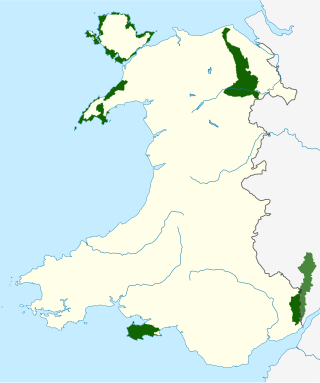
There are five Areas of Outstanding Natural Beauty (AONBs) in Wales, known from November 2023 as National Landscapes. AONBs are areas of countryside that have been designated for statutory protection, due to their significant landscape value, by initially the Government of the United Kingdom and later Welsh devolved bodies. Of the current five areas designated, four are wholly in Wales, with another spanning the Wales-England border, and in total AONBs account for 4% of Wales' land area.

The Chiltern Hills or the Chilterns are a chalk escarpment in southern England, northwest of London, covering 660 square miles (1,700 km2) across Oxfordshire, Buckinghamshire, Hertfordshire, and Bedfordshire, stretching 45 miles (72 km) from Goring-on-Thames in the southwest to Hitchin in the northeast. The hills are 12 miles (19 km) at their widest.

The South Downs National Park is England's newest national park, designated on 31 March 2010. The park, covering an area of 1,627 square kilometres (628 sq mi) in southern England, stretches for 140 kilometres (87 mi) from Winchester in the west to Eastbourne in the east, through the counties of Hampshire, West Sussex and East Sussex. The national park covers the chalk hills of the South Downs and a substantial part of a separate physiographic region, the western Weald, with its heavily wooded sandstone and clay hills and vales. The South Downs Way spans the entire length of the park and is the only National Trail that lies wholly within a national park.
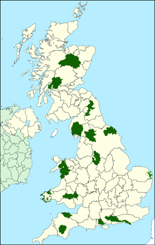
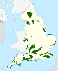
National parks of the United Kingdom are 15 areas of relatively undeveloped and scenic landscape across the country. Despite their name, they are quite different from national parks in many other countries, which are usually owned and managed by governments as protected community resources, and which do not usually include permanent human communities. In the United Kingdom, an area designated as a national park may include substantial settlements and human land uses that are often integral parts of the landscape. Land within national parks remains largely in private ownership. These parks are therefore not "national parks" according to the internationally accepted standard of the IUCN but they are areas of outstanding landscape where planning controls are a little more restrictive than elsewhere.
The National Parks and Access to the Countryside Act 1949 is an Act of the Parliament of the United Kingdom which created the National Parks Commission which later became the Countryside Commission and then the Countryside Agency, which became Natural England when it merged with English Nature in 2006. The Act provided the framework for the creation of National Parks and Areas of Outstanding Natural Beauty in England and Wales, and also addressed public rights of way and access to open land.

The Kent Downs is an Area of Outstanding Natural Beauty (AONB) in Kent, England. They are the eastern half of the North Downs and stretch from the London/Surrey borders to the White Cliffs of Dover, including a small section of the London Borough of Bromley. The AONB also includes the Greensand Ridge, a prominent sandstone escarpment which lies south of the chalk escarpment of the North Downs.

The High Weald National Landscape is in south-east England. Covering an area of 1,450 square kilometres (560 sq mi), it takes up parts of Kent, Surrey, East Sussex, and West Sussex. It is the fourth largest Area of Outstanding Natural Beauty (AONB) in England and Wales. It has an attractive landscape with a mosaic of small farms and woodlands, historic parks, sunken lanes and ridge-top villages.

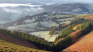
The Howardian Hills are a range of hills in England located between the Yorkshire Wolds, the North York Moors, and the Vale of York. They are named after the Howard family, who still own land locally, and have been designated a National Landscape.

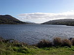
The Wye Valley is a valley in Wales and England. The River Wye is the fourth-longest river in the United Kingdom.

Wales, a country that is part of the United Kingdom, contains protected areas under various designations. The largest designation by land area is Wales' three national parks, followed by the five Areas of Outstanding Natural Beauty.

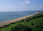
The Cornwall National Landscape covers 958 square kilometres (370 sq mi) in Cornwall, England, United Kingdom; that is, about 27% of the total area of the county. It comprises 12 separate areas, designated under the National Parks and Access to the Countryside Act 1949 for special landscape protection. Of the areas, eleven cover stretches of coastline; the twelfth is Bodmin Moor. The areas are together treated as a single Area of Outstanding Natural Beauty (AONB): all AONBs have been rebranded as National Landscapes since November 2023. Section 85 of the Countryside and Rights of Way Act 2000 places a duty on all relevant authorities when discharging any function affecting land within an AONB to have regard to the purpose of conserving and enhancing natural beauty. Section 89 places a statutory duty on Local Planning Authorities with an AONB within their administrative area to produce a 5-year management plan.

National scenic area (NSA) is a conservation designation used in Scotland, and administered by NatureScot on behalf of the Scottish Government. The designation's purpose is to identify areas of exceptional scenery and to protect them from inappropriate development. There are currently 40 national scenic areas (NSAs) in Scotland, covering 13% of the land area of Scotland. The areas protected by the designation are considered to represent the type of scenic beauty "popularly associated with Scotland and for which it is renowned". As such they tend to be mainly found in remote and mountainous areas, with a review in 1997 noting a potential weakness of national scenic areas was that the original selection placed undue emphasis on mountainous parts of the country. National scenic areas do however also cover seascapes, with approximately 26% of the total area protected by the designation being marine. The designation is primarily concerned with scenic qualities, although designated national scenic areas may well have other special qualities, for example related to culture, history, archaeology, geology or wildlife. Areas with such qualities may be protected by other designations that overlap with the NSA designation.
The Clwydian Range and Dee Valley is a designated Area of Outstanding Natural Beauty located in north-east Wales, covering the Clwydian Range, and the valley of the River Dee.

Dorset National Landscape is a National Landscape area in Dorset, southern England, formerly known as and still legally designated as the Dorset Area of Outstanding Natural Beauty (AONB). The conservation designation means that the area is protected and promoted for its landscape value. The area was established in 1959, one of the early wave of National Landscapes to receive the designation.