Related Research Articles
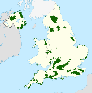
An Area of Outstanding Natural Beauty is an area of countryside in England, Wales, and Northern Ireland, that has been designated for conservation due to its significant landscape value. Areas are designated in recognition of their national importance by the relevant public body: Natural England, Natural Resources Wales, and the Northern Ireland Environment Agency respectively. In place of AONB, Scotland uses the similar national scenic area (NSA) designation. Areas of Outstanding Natural Beauty enjoy levels of protection from development similar to those of UK national parks, but unlike national parks the responsible bodies do not have their own planning powers. They also differ from national parks in their more limited opportunities for extensive outdoor recreation.

County Down is one of the six counties of Northern Ireland, one of the nine counties of Ulster and one of the traditional thirty-two counties of Ireland. It covers an area of 961 sq mi (2,490 km2) and has a population of 531,665. It borders County Antrim to the north, the Irish Sea to the east, County Armagh to the west, and County Louth across Carlingford Lough to the southwest.
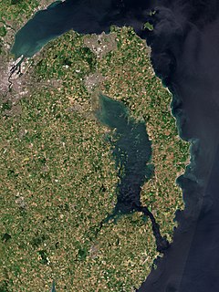
Strangford Lough is a large sea loch or inlet in County Down, in the east of Northern Ireland. It is the largest inlet in Ireland and the British Isles, covering 150 km2 (58 sq mi). The lough is almost fully enclosed by the Ards Peninsula and is linked to the Irish Sea by a long narrow channel at its southeastern edge. The main body of the lough has at least seventy islands along with many islets (pladdies), bays, coves, headlands and mudflats. Historically it was called 'Lough Coan', while 'Strangford' referred to the narrow sea channel. It is part of the 'Strangford and Lecale' Area of Outstanding Natural Beauty. Strangford Lough was designated as Northern Ireland's first Marine Conservation Zone in 2013, and has also been designated a Special Area of Conservation for its important wildlife.
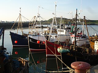
Ardglass is a coastal fishing village, townland and civil parish in County Down, Northern Ireland, in the historic barony of Lecale Lower. It is still a relatively important fishing harbour. It is situated on the B1 Ardglass to Downpatrick road, about 6 miles to the south east of Downpatrick, in the Lecale peninsula on the Irish Sea. It had a population of 1,668 in the 2001 Census, and is located within the Newry, Mourne and Down area.
Ards was a local government district in Northern Ireland with the status of borough. It was one of twenty-six districts formed on 1 October 1973, and had its headquarters in Newtownards. It was merged with neighbouring North Down on 1 May 2015 to form the new Borough of Ards and North Down. Other towns in the defunct Borough included Portaferry, Comber, and Donaghadee, and the population of the area was 78,078 according to the 2011 census.

The Quoile is a river in County Down, Northern Ireland.

Clough is a village and townland in County Down, Northern Ireland. It sits about 3 miles from Dundrum on the A2 between Newcastle and Belfast. The A2 continues via Downpatrick and the coast via Strangford and the Portaferry - Strangford Ferry to Portaferry to Belfast, whilst most road traffic heads along from Clough along the A24 via Carryduff to Belfast. It had a population of 255 people in the 2001 Census. Clough is situated within the Newry, Mourne and Down area.

Saul is a village in County Down, Northern Ireland, within the civil parish of Saul and Ballee.

Strangford is a small village at the mouth of Strangford Lough, on the Lecale peninsula in County Down, Northern Ireland. It has a population of 475 according to the 2001 Census.

Kilclief Castle is a tower-house castle beside Strangford Lough and 2.5 miles (4 km) south of the village of Strangford, County Down, Northern Ireland. Kilclief is a hamlet of historical value on the Strangford to Ardglass road.

The A20 is a road in County Down in Northern Ireland. It runs from Belfast to Newtownards and on to Portaferry.
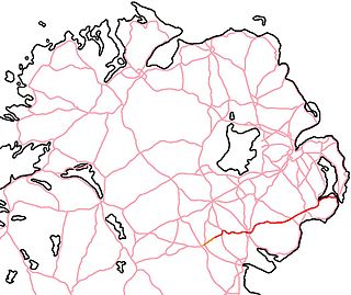
The A25 is the name given to the sections of the main route connecting Strangford with Castleblayney that lie in Northern Ireland. It is a road of regional importance, serving much of south Armagh and south Down. The road commences in the village of Strangford, on the shores of Strangford Lough, from which the Portaferry - Strangford Ferry service transports vehicles to Portaferry on the Ards peninsula. The entirety of the route is 61.2 miles, of which 54.5 miles are located north of the border, forming the A25 - the remaining 6.7 miles form the R182 in the Republic of Ireland.
Dufferin is a historic barony in County Down, Northern Ireland. It is on the southern half of the west shore of Strangford Lough, and is bordered by three other baronies: Castlereagh Lower to the north; Castlereagh Upper to the west; and Lecale Lower to the south.
Ards Upper is a barony in County Down, Northern Ireland. It lies on the southern half of the Ards Peninsula in the east of the county, with the Irish Sea to its east and Strangford Lough to its west. It is bordered by two other baronies: Ards Lower to the north; and Lecale Lower just across the mouth of Strangford Lough to the south.

Lecale Lower is a barony in County Down, Northern Ireland. It lies to the east of the county with Strangford Lough to its north and the Irish Sea to its right. It is bordered by five other baronies: Lecale Upper to the south; Ards Upper to the north-east just across the mouth of Strangford Lough; Dufferin to the north; Castlereagh Upper to the north-west; and Kinelarty to the west.

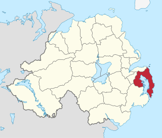
Lecale is a peninsula in the east of County Down, Northern Ireland. It lies between Strangford Lough and Dundrum Bay. In the Middle Ages it was a district or túath in the Gaelic Irish kingdom of Ulaid, then became a county in the Anglo-Norman Earldom of Ulster. Later it became a barony, which was split into Lecale Lower and Lecale Upper by 1851. Its largest settlement is the town of Downpatrick. Other settlements include Ardglass, Killough and Strangford. The peninsula has a high concentration of tower houses. Much of it is part of the 'Strangford and Lecale' Area of Outstanding Natural Beauty.
Gores Island, also known as Gore's Island, is an island in Strangford Lough, County Down, Northern Ireland. It is connected to nearby Castle Island, and thence to the mainland, by a narrow roadway (causeway) that is passable only at low tides. It has been inhabited previously, but has had no residents since the early 20th century.

Delamont Country Park is located on the shores of Strangford Lough in County Down, Northern Ireland. It covers an area of approximately 200 acres 2 km south of Killyleagh. It is currently maintained by Newry, Mourne and Down District Council having previously been under the control of Down District Council.

Dundrum Bay is a bay located next to Dundrum, County Down, Northern Ireland. It is divided into the Outer Bay, and the almost entirely landlocked Inner Bay. They are separated by the dune systems of Ballykinler to the north and Murlough to the south. The bay was home to a roughly year-long "shipwreck" of the SS Great Britain; in actuality, the "wreck" was a period of time in which the ship had run aground of a sandbar. The Dundrum Coastal Path, a part of the larger Lecale Way, is a hiking trail that winds along the fronts of the bay; the trek is often visited by birdwatchers. The Blackstaff River, Ardilea, Moneycarragh and the Carrigs River all empty into the bay. The inner bay comprises extensive tidal mud and sand flats and is important for wintering wildfowl.

Saint John's Point or St. John's Point is a cape at the southern tip of the Lecale peninsula of County Down Northern Ireland, separating Dundrum Bay from Killough Harbour, which forms its northern extremity. The cape is mostly surrounded by the Irish Sea and derives its name from a now ruined church dedicated to Saint John, being recorded here since at least 1170. A well known beacon in the north-eastern Irish Sea, St. John's Point Lighthouse, built in 1844, sits near its southern tip and, at 40 m (130 ft), is the tallest lighthouse in Ireland.
References
- ↑ Lecale Coast AONB
- ↑ http://www.doeni.gov.uk/niea/de/protected_areas_home/aonb/strangford_and_lecale_aonb-2.htm Northern Ireland Environment Agency
 | ||
Areas marked † are proposed | ||
Coordinates: 54°16′23″N5°34′34″W / 54.273°N 5.576°W
| | This article related to the geography of County Down, Northern Ireland is a stub. You can help Wikipedia by expanding it. |