Antrim Coast and Glens

Last updated

The Antrim coast road near Glenarm The coast road near Glenarm - geograph.org.uk - 946278.jpg
The Antrim coast road near Glenarm
Breakers on Antrim Coast near Ballycastle, Northern Ireland, with cliffs of Fair Head. Scotland appears in the distance on clear days. Antrim Coast near Ballycastle.JPG
Breakers on Antrim Coast near Ballycastle, Northern Ireland, with cliffs of Fair Head. Scotland appears in the distance on clear days.

The Antrim Coast and Glens is an area of County Antrim in Northern Ireland, designated as an Area of Outstanding Natural Beauty in 1988. [1]

Contents

Description

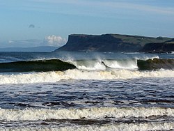
The Antrim Coasts and Glens AONB extends to include Rathlin Island, the Glens of Antrim and the coastal area between Larne and Ballycastle, and is dominated by the Antrim Plateau which is 500 metres (1,600 ft) at its highest point. This plateau is incised by rapidly flowing rivers into a series of glens which run eastwards and north-eastwards into the sea. The coastline within the AONB includes the only inhabited offshore island in Ireland, dramatic headlands and bays, farmland and, in the uplands, open expanses of moorland. There is a long history of human activity in the areas and has many important archaeological sites, listed buildings, historic monuments and conservation areas. It has a rich culture with close links to Scotland, the Mull of Kintyre is only 20 kilometres (12 mi) from Torr Head. [2] The AONB covers an area of 70,600 hectares (174,000 acres). [3]

Geology

The oldest rocks in the AONB are the schists exposed in its northwest which are 300 million years old. Elsewhere these are overlain by a varied geology which includes both igneous and sedimentary rocks and the colours and features these rocks give to the landscape are reflected in many local place names such as red Bay, Blackcave and Whitebay. The most recent force to shape the landscape were the glaciations, the last of which ended around 17,000 years before the present. The ice has moulded the landscape in the AONB, leaving scars in the rocks and scouring out hollows which have filled with water to create small loughs and bogs. [1]

Natural history

There are a number of habitats within the AONB, the largest area is the open landscape of the Antrim Plateau. This is partially covered with blanket bog and is home to ground nesting birds of open country like red grouse and hen harrier. It also provides habitat for a number of rare plants, for example the insectivorous butterwort. The varied coastline is important to wildlife too, including aquatic mammals such as cetaceans, seals and the odd otter. Rathlin Island is an important site for breeding seabirds and in the breeding season 250,000 of them come to the island, these include species such as razorbill, kittiwake and puffin. The coastline is also important for its invertebrate fauna, including rare sponges. The woodlands and fields provide homes to a variety of species and these include mammals, insects and wild flowers. [2]

Cultural heritage

The area's links with Scotland are reflected in the culture and the ancient kingdom of Dalriada covered north eastern Ireland and parts of western Scotland, its kings eventually becoming the kings of the Kingdom of Scotland. [4] Later the area was fought over by a number of Irish clans while Glenarm Castle has been the seat of the McDonnell Clan for 400 years. It is home to a rich mythology and, especially in the middle part to traditional Irish pursuits such as hurling. Today the area has a working landscape of farms and fishing villages. [2]

See also

Notes and references

  1. 1 2 "Antrim Coast and Glens AONB". Department of Agriculture, Environment and Rural Affairs. Retrieved 25 March 2020.
  2. 1 2 3 "About the AONB". Causeway Coast & Glens Heritage Trust. Retrieved 25 March 2020.
  3. "Local Development Plan 2030 Technical Supplement 10 Appendix A - Landscape Character Assessment" (PDF). Mid & East Antrim Borough Council. September 2019. Retrieved 25 March 2020.
  4. "Dalriada historical kingdom, Ireland". Encyclopaedia Britannica. Retrieved 25 March 2020.

Related Research Articles

County Antrim County in Northern Ireland

County Antrim is one of six counties that form Northern Ireland. Adjoined to the north-east shore of Lough Neagh, the county covers an area of 3,046 square kilometres (1,176 sq mi) and has a population of about 618,000. County Antrim has a population density of 203 people per square kilometre or 526 people per square mile. It is also one of the thirty-two traditional counties of Ireland, as well as part of the historic province of Ulster.

Ballycastle, County Antrim Human settlement in Northern Ireland

Ballycastle is a small seaside town in County Antrim, Northern Ireland. It is on the north-easternmost coastal tip of Ireland, in the Antrim Coast and Glens Area of Outstanding Natural Beauty. The harbour hosts the ferry to Rathlin Island, which can be seen from the coast. The Ould Lammas Fair is held each year in Ballycastle on the last Monday and Tuesday of August. Ballycastle is the home of the Corrymeela Community.

Rathlin Island Human settlement in Northern Ireland

Rathlin Island is an island and civil parish off the coast of County Antrim in Northern Ireland. It is Northern Ireland's northernmost point.

Larne Town (and civil parish) in County Antrim, Northern Ireland

Larne is a town on the east coast of County Antrim, Northern Ireland, with a population of 18,755 at the 2011 Census. It is a major passenger and freight roll-on roll-off port. Larne is administered by Mid and East Antrim Borough Council. Together with parts of the neighbouring districts of Antrim and Newtownabbey and Causeway Coast and Glens, it forms the East Antrim constituency for elections to the Westminster Parliament and Northern Ireland Assembly. The civil parish is in the historic barony of Glenarm Upper.

Mull of Kintyre Headland in Scotland

The Mull of Kintyre is the southwesternmost tip of the Kintyre Peninsula in southwest Scotland. From here, the Antrim coast of Northern Ireland is visible on a calm and clear day, and a historic lighthouse, the second commissioned in Scotland, guides shipping in the intervening North Channel. The area has been immortalised in popular culture by the 1977 hit song "Mull of Kintyre" by Kintyre resident Paul McCartney's band of the time, Wings.

Moyle District Council Human settlement in Northern Ireland

Moyle District Council was a local council in County Antrim in the northeast of Northern Ireland. It merged with Ballymoney Borough Council, Coleraine Borough Council and Limavady Borough Council in May 2015 under local government reorganisation to become Causeway Coast and Glens District Council.

The Copeland Islands is a group of three islands in the north Irish Sea, north of Donaghadee, County Down, Northern Ireland, consisting of Lighthouse Island, Copeland Island, and Mew Island. They lie within the civil parish of Bangor.

North Antrim (UK Parliament constituency) Parliamentary constituency in the United Kingdom, 1950 onwards

North Antrim is a parliamentary constituency in the United Kingdom House of Commons. The current MP is Ian Paisley Jr of the DUP.

Whitehead, County Antrim Human settlement in Northern Ireland

Whitehead is a small seaside town on the east coast of County Antrim, Northern Ireland, lying almost midway between the towns of Carrickfergus and Larne. It lies within the civil parish of Templecorran, the historic barony of Belfast Lower, and is part of Mid and East Antrim Borough Council. Before the Plantation of Ulster its name was recorded as both Whitehead and Kinbaine.

Belfast Lough Large, intertidal sea inlet on the east coast of Northern Ireland

Belfast Lough is a large, intertidal sea inlet on the east coast of Northern Ireland. At its head is the city and port of Belfast, which sits at the mouth of the River Lagan. The lough opens into the North Channel and connects Belfast to the Irish Sea.

Glenarm Human settlement in Northern Ireland

Glenarm is a village in County Antrim, Northern Ireland. It lies on the North Channel coast north of the town of Larne and the village of Ballygalley, and south of the village of Carnlough. It is situated in the civil parish of Tickmacrevan and the historic barony of Glenarm Lower. It is part of Mid and East Antrim Borough Council and had a population of 1,851 people in the 2011 Census. Glenarm takes its name from the glen in which it lies, the southernmost of the nine Glens of Antrim.

A2 road (Northern Ireland)

The A2 is a major road in Northern Ireland, a considerable length of which is often referred to the Antrim Coast Road because much of it follows the scenic coastline of County Antrim; other parts of the road follow the coasts in Counties Down and Londonderry.

Glynn village and civil parish

Glynn is a small village and civil parish in the Mid and East Antrim Borough Council area of County Antrim, Northern Ireland. It lies a short distance south of Larne, on the shore of Larne Lough. Glynn had a population of 2,027 people in the 2011 Census.

Whiteabbey townland in Northern Ireland, United Kingdom

Whiteabbey is a townland in Newtownabbey, north of Belfast in County Antrim, Northern Ireland.

Belfast–Larne line

The Belfast–Larne line, or Larne line, is a railway line in Northern Ireland, operated by Northern Ireland Railways. It runs as double track along the majority of its route north along the scenic east Antrim coastline from Belfast to the coastal seaport town of Larne, serving commuters and ferry passengers.

Tievebulliagh

Tievebulliagh is a 402-metre-high (1,319 ft) mountain in the Glens of Antrim, Northern Ireland. It forms part of the watershed between Glenaan to the north and Glenballyemon to the south. It is situated about 4.4 km from Cushendall.

Causeway Coast and Glens Local government district in Northern Ireland

Causeway Coast and Glens is a local government district covering most of the northern part of Northern Ireland. It was created on 1 April 2015 by merging the Borough of Ballymoney, the Borough of Coleraine, the Borough of Limavady and the District of Moyle. The local authority is Causeway Coast and Glens Borough Council.

Scawt Hill

Scawt Hill is a volcanic plug in County Antrim, Northern Ireland, in the borough of Larne, 5 km from the village of Ballygally.