Cove

Last updated
McWay Cove, California, United States McWay cove 1.jpg
McWay Cove, California, United States

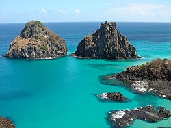
A cove is a small type of bay or coastal inlet. Coves usually have narrow, restricted entrances, are often circular or oval, and are often situated within a larger bay. Small, narrow, sheltered bays, inlets, creeks, or recesses in a coast are often considered coves.

Colloquially, the term can be used to describe a sheltered bay. Geomorphology describes coves as precipitously walled and rounded cirque-like openings as in a valley extending into or down a mountainside, or in a hollow or nook of a cliff or steep mountainside. A cove can also refer to a corner, nook, or cranny, either in a river, road, or wall, especially where the wall meets the floor.

A notable example is Lulworth Cove on the Jurassic Coast in Dorset, England. To its west, a second cove, Stair Hole, is forming.

Formation

Map showing two examples of how coves form. The rock types are those of Lulworth Cove. In example A, a river breaks through the resistant chalk back rock and limestone, leaving the weak clays to be rapidly eroded. In example B, the sea breaks through the limestone, perhaps by forming a cave, and then erodes the clay away. Figure lulworth formation.png
Map showing two examples of how coves form. The rock types are those of Lulworth Cove. In example A, a river breaks through the resistant chalk back rock and limestone, leaving the weak clays to be rapidly eroded. In example B, the sea breaks through the limestone, perhaps by forming a cave, and then erodes the clay away.

Coves are formed by differential erosion, which occurs when softer rocks are worn away faster than the harder rocks surrounding them. These rocks further erode to form a circular bay with a narrow entrance, called a cove.

Related Research Articles

<span class="mw-page-title-main">Fjord</span> Long, narrow inlet with steep sides or cliffs, created by glacial activity

In physical geography, a fjord or fiord is a long, narrow sea inlet with steep sides or cliffs, created by a glacier. Fjords exist on the coasts of Antarctica, British Columbia (Canada), Chile, Denmark, Germany, Greenland (Denmark), the Faroe Islands (Denmark), Montenegro, Iceland, Ireland, Kamchatka (Russia), the Kerguelen Islands (France), Newfoundland and Labrador (Canada), New Zealand, Norway, Novaya Zemlya (Russia), Nunavut (Canada), Quebec (Canada), Argentina, Russia, South Georgia Island, Tasmania (Australia), Scotland and the states of Washington, Maine, and Alaska. Norway's coastline is estimated to be 29,000 km (18,000 mi) long with its nearly 1,200 fjords, but only 2,500 km (1,600 mi) long excluding the fjords.

Firth is a word in the English and Scots languages used to denote various coastal waters in the United Kingdom, predominantly within Scotland. In the Northern Isles, it more often refers to a smaller inlet. It is linguistically cognate to fjord, which has a more constrained sense in English. Bodies of water named "firths" tend to be more common on the Scottish east coast, or in the southwest of the country, although the Firth of Clyde is an exception to this. The Highland coast contains numerous estuaries, straits, and inlets of a similar kind, but not called "firth" ; instead, these are often called sea lochs. Before about 1850, the spelling "Frith" was more common.

<span class="mw-page-title-main">Signy Island</span> Island of Antarctica

Signy Island is a small subantarctic island in the South Orkney Islands of Antarctica. It was named by the Norwegian whaler Petter Sørlle (1884–1933) after his wife, Signy Therese.

<span class="mw-page-title-main">Gros Morne National Park</span> National Park on the west coast of Newfoundland

Gros Morne National Park is a Canadian national park and World Heritage Site located on the west coast of Newfoundland. At 1,805 km2 (697 sq mi), it is the second largest national park in Atlantic Canada after Torngat Mountains National Park, which has an area of 9,700 km2 (3,700 sq mi).

<span class="mw-page-title-main">Lulworth Cove</span> Lolworth Cove is on the Jurassic Coast

Lulworth Cove is a cove near the village of West Lulworth, on the Jurassic Coast in Dorset, southern England. The cove is one of the world's finest examples of such a landform, and is a World Heritage Site and tourist location with approximately 500,000 visitors every year, of whom about 30 per cent visit in July and August. It is close to the rock arch of Durdle Door and other Jurassic Coast sites.

Landforms are categorized by characteristic physical attributes such as their creating process, shape, elevation, slope, orientation, rock exposure, and soil type.

<span class="mw-page-title-main">Port Jackson</span> Body of water in Sydney, Australia

Port Jackson, consisting of the waters of Sydney Harbour, Middle Harbour, North Harbour and the Lane Cove and Parramatta Rivers, is the ria or natural harbour of Sydney, New South Wales, Australia. The harbour is an inlet of the Tasman Sea. It is the location of the Sydney Opera House and Sydney Harbour Bridge. The location of the first European settlement and colony on the Australian mainland, Port Jackson has continued to play a key role in the history and development of Sydney.

<span class="mw-page-title-main">Barrier island</span> Coastal dune landform that forms by wave and tidal action parallel to the mainland coast

Barrier islands are a coastal landforms—a type of dune system and sand island—where an area of sand has been formed by wave and tidal action parallel to the mainland coast. They usually occur in chains, consisting of anything from a few islands to more than a dozen. They are subject to change during storms and other action, but absorb energy and protect the coastlines and create areas of protected waters where wetlands may flourish. A barrier chain may extend for hundreds of kilometers, with islands periodically separated by tidal inlets. The largest barrier island in the world is Padre Island of Texas, United States, at 113 miles (182 km) long. Sometimes an important inlet may close permanently, transforming an island into a peninsula, thus creating a barrier peninsula, often including a beach, barrier beach. Though many are long and narrow, the length and width of barriers and overall morphology of barrier coasts are related to parameters including tidal range, wave energy, sediment supply, sea-level trends, and basement controls. The amount of vegetation on the barrier has a large impact on the height and evolution of the island.

<span class="mw-page-title-main">Concordant coastline</span> Type of coastline created by the folding of differing rock layers parallel to the coast

In coastal geography, a concordant, longitudinal, or Pacific type coastline occurs where beds, or layers, of differing rock types are folded into ridges that run parallel to the coast. The outer hard rock provides a protective barrier to erosion of the softer rocks further inland. Sometimes the outer hard rock is punctured, allowing the sea to erode the softer rocks behind. This creates a cove, a circular area of water with a relatively narrow entrance from the sea.

<span class="mw-page-title-main">Durdle Door</span> Natural limestone arch on the Jurassic coast of England

Durdle Door is a natural limestone arch on the Jurassic Coast near Lulworth in Dorset, England. It is privately owned by the Weld Family who own the Lulworth Estate, but it is also open to the public.

<span class="mw-page-title-main">Inlet</span> Indentation of a shoreline

An inlet is a indentation of a shoreline, such as a small arm, bay, sound, fjord, lagoon or marsh, that leads to an enclosed larger body of water such as a lake, estuary, gulf or marginal sea.

<span class="mw-page-title-main">Helvellyn</span> Mountain in the English Lake District

Helvellyn is a mountain in the English Lake District, the highest point of the Helvellyn range, a north–south line of mountains to the north of Ambleside, between the lakes of Thirlmere and Ullswater.

<span class="mw-page-title-main">Terra Nova National Park</span> National park in Newfoundland and Labrador, Canada

Terra Nova National Park is located on the east coast of Newfoundland in the Canadian province of Newfoundland and Labrador, along several inlets of Bonavista Bay. The park takes its name from the Latin name for Newfoundland; it is also the original Portuguese name given to the region.

<span class="mw-page-title-main">Cadgwith</span> Human settlement in England

Cadgwith is a village and fishing port in Cornwall, England, United Kingdom. It is on the Lizard Peninsula between The Lizard and Coverack. It is in the civil parish of Grade Ruan.

<span class="mw-page-title-main">Bay</span> Recessed, coastal body of water connected to an ocean or lake

A bay is a recessed, coastal body of water that directly connects to a larger main body of water, such as an ocean, a lake, or another bay. A large bay is usually called a gulf, sea, sound, or bight. A cove is a small, circular bay with a narrow entrance. A fjord is an elongated bay formed by glacial action.

Jason Harbour is a bay 1 mile (1.6 km) wide, lying west of Allen Bay in the north side of Cumberland West Bay, South Georgia. It was charted and named by the Swedish Antarctic Expedition, 1901–04, under Otto Nordenskiöld. The bay was previously visited by the Jason, Captain C.A. Larsen, in 1894.

<span class="mw-page-title-main">Cordova Bay</span> Bay in the Alexander Archipelago of Alaska

Cordova Bay is a bay in the Alexander Archipelago of southeast Alaska. It opens onto Dixon Entrance to the south, between Cape Muzon on Dall Island and Point Marsh. The name Puerto Cordova y Cordova was given by the Spanish explorer Lieutenant Don Jacinto Caamaño in 1792, in honor of Admiral Luis de Córdova y Córdova. The name was published by George Vancouver in 1798.

<span class="mw-page-title-main">Carsaig Bay</span>

Carsaig Bay is a cove on the Ross of Mull in the south of the Isle of Mull, off the west coast of Scotland. It is situated 5 kilometres eastward of Rudha Fhaoilean, and 7 km south of Pennyghael. The bay is small and is surrounded by high, precipitous hills. It is unsafe for water craft, except in the part sheltered by the island of Gamhnach Mhòr, where small vessels can obtain anchorage. The northeastern part of Carsaig Bay is rocky and foul from 180–370 metres offshore from the eastern end of Gamhnach Mhòr to the head of the bay. Three of the rocks are marked by perches to facilitate the approach to Carsaig Quay. The tidal streams along the south coast of Mull are weak westward of Carsaig Bay.

<span class="mw-page-title-main">St Magnus Bay</span> Bay in Northwest of Mainland, Shetland

St Magnus Bay is a large coastal feature in the north-west of Mainland Shetland, Scotland. Roughly circular in shape with a diameter of about 19 kilometres (12 mi), it is open to the North Atlantic Ocean to the west. The indented coastline to the north, south and east between Esha Ness in the north and the Ness of Melby in the south contains numerous bays, firths and voes and there are several islands around the perimeter. The waters of the bay are up to 165 metres (541 ft) deep and may have been the site of a substantial meteor impact.

Moira Sound is a branching inlet on the east side of the southern end of Prince of Wales Island in U.S. state of Alaska. It is situated within the Tongass National Forest.

References