Sea cave

Last updated
Sea cave formation along a fault on Santa Cruz Island, California, United States Seacave fault.jpg
Sea cave formation along a fault on Santa Cruz Island, California, United States

A sea cave, also known as a littoral cave, is a type of cave formed primarily by the wave action of the sea. The primary process involved is erosion. Sea caves are found throughout the world, actively forming along present coastlines and as relict sea caves on former coastlines. Some of the largest wave-cut caves in the world are found on the coast of Norway, but are now 100 feet or more above present sea level. [1] These would still be classified as littoral caves. By contrast, in places like Thailand's Phang Nga Bay, solutionally formed caves in limestone have been flooded by the rising sea and are now subject to littoral erosion, representing a new phase of their enlargement.

Contents

Some of the best-known sea caves are European. Fingal's Cave, on the island of Staffa in Scotland, is a spacious cave some 70 m long, formed in columnar basalt. The Blue Grotto of Capri, although smaller, is famous for the apparent luminescent quality of its water, imparted by light passing through underwater openings. The Romans built a stairway in its rear and a now-collapsed tunnel to the surface. The Greek islands are also noted for the variety and beauty of their sea caves. Numerous sea caves have been surveyed in England, Scotland, and in France, particularly on the Normandy coast. Until 2013, the largest known sea caves were found along the west coast of the United States, the Hawaiian islands, and the Shetland Islands. In 2013 the discovery and survey of the world's largest sea cave was announced. [2] Matainaka Cave – located on the Otago coast of New Zealand's South Island – has proven to be the world's most extensive at 1.5 km in length. Also in 2013, Crossley reported a newly surveyed complex reaching just over a kilometer in survey at Bethells Beach on New Zealand's North Island. [3]

Formation

Sea cave collapse Littoral sinkhole.jpg
Sea cave collapse

Littoral caves may be found in a wide variety of host rocks, ranging from sedimentary to metamorphic to igneous, but caves in the latter tend to be larger due to the greater strength of the host rock. However, there are some notable exceptions as discussed below.

In order to form a sea cave, the host rock must first contain a weak zone. In metamorphic or igneous rock, this is typically either a fault as in the caves of the Channel Islands of California, or a dike as in the large sea caves of Kauai, Hawaii’s Na Pali Coast. [4] [5] In sedimentary rocks, this may be a bedding-plane parting or a contact between layers of different hardness. The latter may also occur in igneous rocks, such as in the caves on Santa Cruz Island, California, where waves have attacked the contact between the andesitic basalt and the agglomerate. [6]

The driving force in littoral cave development is wave action. Erosion is ongoing anywhere that waves batter rocky coasts, but where sea cliffs contain zones of weakness, rock is removed at a greater rate along these zones. As the sea reaches into the fissures thus formed, they begin to widen and deepen due to the tremendous force exerted within a confined space, not only by direct action of the surf and any rock particles that it bears, but also by compression of air within. Blowholes (partially submerged caves that eject large sprays of sea water as waves retreat and allow rapid re-expansion of air compressed within) attest to this process. Adding to the hydraulic power of the waves is the abrasive force of suspended sand and rock. Most sea-cave walls are irregular and chunky, reflecting an erosional process where the rock is fractured piece by piece. However, some caves have portions where the walls are rounded and smoothed, typically floored with cobbles, and result from the swirling motion of these cobbles in the surf zone.

Akun Island basalt sea cave Akun Island basalt sea cave.jpg
Akun Island basalt sea cave

True littoral caves should not be confused with inland caves that have been intersected and revealed when a sea cliff line is eroded back, or with dissolutional voids formed in the littoral zone on tropical islands. In some regions, such as Halong Bay, Vietnam, caves in carbonate rocks are found in littoral zones, and being enlarged by littoral processes but were originally formed by dissolution. Such caves have been termed as hybrid caves. [7]

Rainwater may also influence sea-cave formation. Carbonic and organic acids leached from the soil may assist in weakening rock within fissures. As in solutional caves, small speleothems may develop in sea caves.

Sea cave chambers sometimes collapse leaving a “littoral sinkhole”. These may be quite large, such as Oregon’s Devil’s Punchbowl or the Queen’s Bath on the Na Pali coast. Small peninsulas or headlands often have caves that cut completely through them, since they are subject to attack from both sides, and the collapse of a sea cave tunnel can leave a free-standing “sea stack” along the coast. The Californian island of Anacapa is thought to have been split into three islets by such a process.

Life within sea caves may assist in their enlargement as well. For example, sea urchins drill their way into the rock, and over successive generations may remove considerable bedrock from the floors and lower walls.

Factors influencing size

Most sea caves are small in relation to other types. A compilation of sea-cave surveys as of July 2014 shows 2 over 1000 meters, 6 over 400 meters, nine over 300 meters, 25 over 200 meters, and 108 over 100 meters in length. In Norway, several apparently relict sea caves exceed 300 meters in length. There is no doubt that many other large sea caves exist but have not been investigated due to their remote locations and/or hostile sea conditions.

Several factors contribute to the development of relatively large sea caves. The nature of the zone of weakness itself is surely a factor, although difficult to quantify. A more readily observed factor is the situation of the cave's entrance relative to prevailing sea conditions. At Santa Cruz Island, the largest caves face into the prevailing northwest swell conditions—a factor which also makes them more difficult to survey. Caves in well-protected bays sheltered from prevailing seas and winds tend to be smaller, as are caves in areas where the seas tend to be calmer.

Exploring a sea cave Seacaving.jpg
Exploring a sea cave

The type of host rock is important as well. Most of the large sea caves on the Western U.S. coast and Hawaii are in basalt, [8] a strong host rock compared to sedimentary rock. Basaltic caves can penetrate far into cliffs where most of the surface erodes relatively slowly. In weaker rock, erosion along a weaker zone may not greatly outstrip that of the cliff face. However, the world's largest sea cave has formed in the heavily fractured Caversham sandstone (Barth, 2013) changing our understanding of which host rocks can form large sea caves.

Time is another factor. The active littoral zone changes throughout geological time by an interplay between sea-level change and regional uplift. Recurrent ice ages during the Pleistocene have changed sea levels within a vertical range of some 200 meters. Significant sea caves have formed in the California Channel Islands that are now totally submerged by the rise in sea levels over the last 12 000 years. In regions of steady uplift, continual littoral erosion may produce sea caves of great height — Painted Cave is almost 40 m high at its entrance. On the Norwegian coast there are huge sea caves now uplifted 30 or more meters above sea level. Sediment dating in the largest of these (Halvikshulen in Osen, 340 m long) shows that it was formed over a period of at least a million years. [9] It may well be the longest wave-cut cave in the world. The largest cave by volume is Rikoriko Cave in the Poor Knights Islands in New Zealand with 221,494 m3. [10]

Finally, caves that are larger tend to be more complex. By far the majority of sea caves consist of a single passage or chamber. Those formed on faults tend to have canyon-like or angled passages that are very straight. In Seal Canyon Cave on Santa Cruz Island, entrance light is still visible from the back of the cave 189 m from the entrance. By contrast, caves formed along horizontal bedding planes tend to be wider with lower ceiling heights. In some areas, sea caves may have dry upper levels, lifted above the active littoral zone by regional uplift.

Sea caves can prove surprisingly complex where numerous zones of weakness—often faults—converge. In Catacombs Cave on Anacapa Island (California), at least six faults intersect. [11] In several caves of the Californian Channel Islands, long fissure passages open up into large chambers beyond. This is invariably associated with intersection of a second fault oriented almost perpendicularly to that along the entrance passage. When caves have multiple entrances, they are exposed to more wave action and hence may grow relatively faster. There is an exceptionally large cave underlying the Fogla Skerry, an islet off the coast of Papa Stour, in the Shetland Islands. [12] Though unsurveyed, estimates place it at almost 500 m of passage. Matainaka Cave in New Zealand has 12 separate entrances into which waves can penetrate and numerous joints along which intersecting passages have developed.

Bibliography

Related Research Articles

<span class="mw-page-title-main">Cave</span> Natural underground space large enough for a human to enter

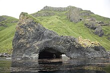
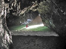
A cave or cavern is a natural void in the ground, specifically a space large enough for a human to enter. Caves often form by the weathering of rock and often extend deep underground. The word cave can refer to smaller openings such as sea caves, rock shelters, and grottos, that extend a relatively short distance into the rock and they are called exogene caves. Caves which extend further underground than the opening is wide are called endogene caves.

<span class="mw-page-title-main">Natural arch</span> Arch-shaped natural rock formation

A natural arch, natural bridge, or rock arch is a natural landform where an arch has formed with an opening underneath. Natural arches commonly form where inland cliffs, coastal cliffs, fins or stacks are subject to erosion from the sea, rivers or weathering.

<span class="mw-page-title-main">Sinkhole</span> Geologically-formed topological depression

A sinkhole is a depression or hole in the ground caused by some form of collapse of the surface layer. The term is sometimes used to refer to doline, enclosed depressions that are locally also known as vrtače and shakeholes, and to openings where surface water enters into underground passages known as ponor, swallow hole or swallet. A cenote is a type of sinkhole that exposes groundwater underneath. Sink and stream sink are more general terms for sites that drain surface water, possibly by infiltration into sediment or crumbled rock.

<span class="mw-page-title-main">Hạ Long Bay</span> UNESCO World Heritage Site in Vietnam

Hạ Long Bay or Halong Bay is a UNESCO World Heritage Site and popular travel destination in Quảng Ninh province, Vietnam. The name Hạ Long means "descending dragon". Administratively, the bay belongs to Hạ Long city, Cẩm Phả city, and is a part of Vân Đồn district. The bay features thousands of limestone karsts and islets in various shapes and sizes. Hạ Long Bay is a center of a larger zone that includes Bai Tu Long Bay to the northeast, and Cát Bà Island to the southwest. These larger zones share a similar geological, geographical, geomorphological, climate, and cultural characters.

<span class="mw-page-title-main">Stack (geology)</span> Geological landform consisting of a steep and often vertical column or columns of rock

A stack or sea stack is a geological landform consisting of a steep and often vertical column or columns of rock in the sea near a coast, formed by wave erosion. Stacks are formed over time by wind and water, processes of coastal geomorphology. They are formed when part of a headland is eroded by hydraulic action, which is the force of the sea or water crashing against the rock. The force of the water weakens cracks in the headland, causing them to later collapse, forming free-standing stacks and even a small island. Without the constant presence of water, stacks also form when a natural arch collapses under gravity, due to sub-aerial processes like wind erosion. Erosion causes the arch to collapse, leaving the pillar of hard rock standing away from the coast—the stack. Eventually, erosion will cause the stack to collapse, leaving a stump. Stacks can provide important nesting locations for seabirds, and many are popular for rock climbing.

Landforms are categorized by characteristic physical attributes such as their creating process, shape, elevation, slope, orientation, rock exposure, and soil type.

<span class="mw-page-title-main">Anacapa Island</span> Island of the Channel Islands in California, United States

Anacapa Island is a small volcanic island located about 11 miles (18 km) off the coast of Port Hueneme, California, in Ventura County. The island is composed of a series of narrow islets 6 mi (10 km) long, oriented generally east–west and 5 mi (8 km) east of Santa Cruz Island. The three main islets, East, Middle and West Anacapa, are collectively known as The Anacapas by some authors. All three islets have precipitous cliffs, dropping off steeply into the sea.

<span class="mw-page-title-main">Channel Islands National Park</span> National park in California, United States

Channel Islands National Park consists of five of the eight Channel Islands off the Pacific coast of the U.S. state of California. Although the islands are close to the shore of the densely populated state, they have been relatively undeveloped. The park covers 249,561 acres (100,994 ha), of which 79,019 acres (31,978 ha) are federal land. The Nature Conservancy owns and manages 76% of Santa Cruz Island, the largest of the eight.

<span class="mw-page-title-main">Deposition (geology)</span> Geological process in which sediments, soil and rocks are added to a landform or landmass

Deposition is the geological process in which sediments, soil and rocks are added to a landform or landmass. Wind, ice, water, and gravity transport previously weathered surface material, which, at the loss of enough kinetic energy in the fluid, is deposited, building up layers of sediment.

<span class="mw-page-title-main">Poor Knights Islands</span> Group of islands and marine reserve off the east coast of New Zealands North Island

The Poor Knights Islands are a group of islands off the east coast of the Northland Region of the North Island of New Zealand. They lie 50 kilometres (31 mi) to the northeast of Whangārei, and 22 kilometres (14 mi) offshore halfway between Bream Head and Cape Brett. Uninhabited since the 1820s, they are a nature reserve and popular underwater diving spot, with boat tours typically departing from Tutukaka. The Poor Knights Islands Marine Reserve surrounds the island.

<span class="mw-page-title-main">Blowhole (geology)</span> Hole at the top of a sea-cave which allows waves to force water or spray out of the hole

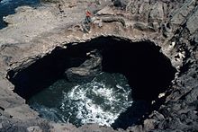
In geology, a blowhole or marine geyser is formed as sea caves grow landward and upward into vertical shafts and expose themselves toward the surface, which can result in hydraulic compression of seawater that is released through a port from the top of the blowhole. The geometry of the cave and blowhole along with tide levels and swell conditions determine the height of the spray.

<span class="mw-page-title-main">Blue hole</span> Marine cavern or sinkhole, open to the surface, in carbonate bedrock

A blue hole is a large marine cavern or sinkhole, which is open to the surface and has developed in a bank or island composed of a carbonate bedrock. Blue holes typically contain tidally influenced water of fresh, marine, or mixed chemistry. They extend below sea level for most of their depth and may provide access to submerged cave passages. Well-known examples are the Dragon Hole and, in the Caribbean, the Great Blue Hole and Dean's Blue Hole.

<span class="mw-page-title-main">Geology of Ireland</span> Study of the rock formations of Ireland

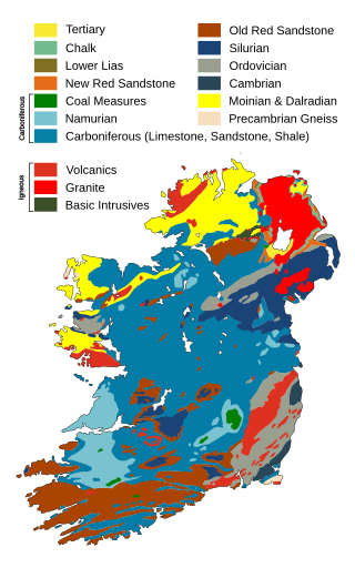
The geology of Ireland consists of the study of the rock formations on the island of Ireland. It includes rocks from every age from Proterozoic to Holocene and a large variety of different rock types is represented. The basalt columns of the Giant's Causeway together with geologically significant sections of the adjacent coast have been declared a World Heritage Site. The geological detail follows the major events in Ireland's past based on the geological timescale.

Beach evolution occurs at the shoreline where sea, lake or river water is eroding the land. Beaches exist where sand accumulated from centuries-old, recurrent processes that erode rocky and sedimentary material into sand deposits. River deltas deposit silt from upriver, accreting at the river's outlet to extend lake or ocean shorelines. Catastrophic events such as tsunamis, hurricanes, and storm surges accelerate beach erosion.

<span class="mw-page-title-main">Sedimentary budget</span>

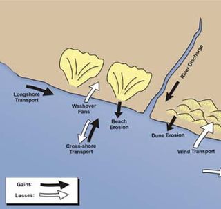
Sedimentary budgets are a coastal management tool used to analyze and describe the different sediment inputs (sources) and outputs (sinks) on the coasts, which is used to predict morphological change in any particular coastline over time. Within a coastal environment the rate of change of sediment is dependent on the amount of sediment brought into the system versus the amount of sediment that leaves the system. These inputs and outputs of sediment then equate to the total balance of the system and more than often reflect the amounts of erosion or accretion affecting the morphology of the coast.

<span class="mw-page-title-main">Geology of New Zealand</span> Overview of the geology of New Zealand

The geology of New Zealand is noted for its volcanic activity, earthquakes and geothermal areas because of its position on the boundary of the Australian Plate and Pacific Plates. New Zealand is part of Zealandia, a microcontinent nearly half the size of Australia that broke away from the Gondwanan supercontinent about 83 million years ago. New Zealand's early separation from other landmasses and subsequent evolution have created a unique fossil record and modern ecology.

<span class="mw-page-title-main">Tantanoola Caves Conservation Park</span> Protected area in South Australia

The Tantanoola Caves Conservation Park is a 14-hectare (35-acre) protected area near Tantanoola in the Limestone Coast tourism region in the south-east of South Australia. The conservation park preserves two main caves; the wheelchair accessible Tantanoola Cave which is developed as a show cave and Lake Cave which is a restricted access cave used by the Department for Environment and Water scientists as a reference site for other karst features in the region. Visitors can explore the information centre and learn about the caves during a guided tour.

<span class="mw-page-title-main">Pancake Rocks and Blowholes</span> Coastal rock formation in New Zealand

The Pancake Rocks and Blowholes are a coastal rock formation at Punakaiki on the West Coast of the South Island of New Zealand. They are a popular visitor attraction.

An anchialine system is a landlocked body of water with a subterranean connection to the ocean. Depending on its formation, these systems can exist in one of two primary forms: pools or caves. The primary differentiating characteristics between pools and caves is the availability of light; cave systems are generally aphotic while pools are euphotic. The difference in light availability has a large influence on the biology of a given system. Anchialine systems are a feature of coastal aquifers which are density stratified, with water near the surface being fresh or brackish, and saline water intruding from the coast at depth. Depending on the site, it is sometimes possible to access the deeper saline water directly in the anchialine pool, or sometimes it may be accessible by cave diving.

References

  1. Sjöberg, Rabbe (1988). "Coastal Caves Indicating Preglacial Morphology in Norway". Cave Science, the Transactions of the British Cave Research Association. 15 (3): 99–103.
  2. Barth, N (October 2013). "Caversham Caves, New Zealand: Breaking the Sea Cave Paradigm". NSS News. 71 (10): 4–14.
  3. Crossley, P. (December 2013). "Bethells Beach Sea Caves". Tomo Times (Journal of the New Zealand Speleological Society). 190: 8.
  4. Moore, D.G. (1954). "Origin and development of sea caves". National Speleological Society Bulletin. 16: 71–76.
  5. Bunnell, D. (2004). "Littoral Caves". In Gunn, J. (ed.). Encyclopedia of Caves and Karst. New York: Fitzroy Dearborn. ISBN   1-57958-399-7.
  6. Bunnell, D. (1988). Sea Caves of Santa Cruz Island. Santa Barbara, CA: McNally and Loftin. ISBN   0-87461-076-1.
  7. Mylroie, J.E. & Mylroie, J.R. (2013). "Pseudokarst Caves in the Littoral Environment". In Lace, M.J. & Mylroie, J.E.. (eds.). Coastal Karst Landforms. New York: Springer. ISBN   978-94-007-5015-9.
  8. Bunnell, D. (2004). "Littoral Caves". In Gunn, J. (ed.). Encyclopedia of Caves and Karst. New York: Fitzroy Dearborn. ISBN   1-57958-399-7.
  9. Sjöberg, Rabbe (1988). "Coastal Caves Indicating Preglacial Morphology in Norway". Cave Science, the Transactions of the British Cave Research Association. 15 (3): 99–103.
  10. Bunnell, D. (May 2004). "Riko Riko Cave, New Zealand-World's Largest Sea Cave ?". NSS News. 62 (5): 145–147.
  11. Bunnell, D. (1993). Sea Caves of Anacapa Island. Santa Barbara, CA: McNally and Loftin. ISBN   0-87461-093-1.
  12. Hansom J.D. (2003). "Papa Stour, Shetland". In May, V.J.; Hansom, J.D. (eds.). Coastal Geomorphology of Great Britain. Geological Conservation Review Series. Vol. 28. Joint Nature Conservancy Committee, UK.