
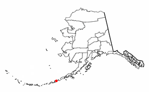
Location in Alaska

Akun Island (Aleut : Akungan [1] ) is one of the Fox Islands subgroup of the Aleutian Islands in the Aleutians East Borough of southwestern Alaska.
Akun Island (Aleut : Akungan [1] ) is one of the Fox Islands subgroup of the Aleutian Islands in the Aleutians East Borough of southwestern Alaska.
The island lies east of Akutan Island and southwest of Unimak Island, across the Unimak Pass strait. The Krenitzin Islands lie to the south and southeast, across the Avatanak Strait.
Akun Island has a land area of 64.39 sq mi (166.77 km²). It is 22.57 kilometres (14.02 mi) long, 18.2 kilometres (11.3 mi) wide.
It is unpopulated, except for airport workers and a few people controlling the cattle. [2]
Akun Island is home to a small but significant population of cows. They are no longer domesticated but the population is controlled. Three domesticated horses also inhabit the island.
With the cessation of amphibious airplane service to Akutan on Akutan Island, the Akutan Seaplane Base closed in 2012. It was replaced by a new $75.5m land-based airstrip six miles (9.7 km) across the water on Akun Island, named Akutan Airport. [3] It was built by Kiewit, R&M Consultants, and DOT.
The airport was connected to Akutan by an expensive hovercraft shuttle, which couldn't operate safely when winds were too strong or waves too high. Operating costs were very high. A helicopter provides the link between Akun and Akutan. [4] The airport has a small hotel, which is used when a flight arrives and the hovercraft is unable to run. [5]

Aleutians East Borough is a 2nd class borough in the U.S. state of Alaska. As of the 2020 census the borough's population was 3,420. The borough seat is Sand Point.
Akutan is a city on Akutan Island in the Aleutians East Borough of the Aleutian Islands in Alaska, United States. The population was 1,589 at the 2020 census, up from 1,027 in 2010, making it the 4th fastest-growing city of the decade in Alaska. Akutan Harbor is adjacent.

False Pass is a city on Unimak Island, in the Aleutians East Borough of southwestern Alaska, United States. Although the population was marked 397 including seasonal fish processing plant workers at the 2020 census, approximately 35 residents call it home year-round.

Sand Point, also known as Popof Island, is a city in Aleutians East Borough, Alaska, United States. At the 2010 census the population was 976, up from 952 in 2000, but by the 2020 Census this had reduced to 578. It is on northwestern Popof Island, one of the Shumagin Islands, off the Alaska Peninsula. It is the borough seat of Aleutians East Borough, and is near the entrance to the Bering Sea.

Unimak Island is the largest island in the Aleutian Islands chain of the U.S. state of Alaska.
The Fox Islands are a group of islands in the eastern Aleutian Islands of the U.S. state of Alaska. The Fox Islands are the closest to mainland North America in the Aleutian chain, and just east of Samalga Pass and the Islands of Four Mountains group.
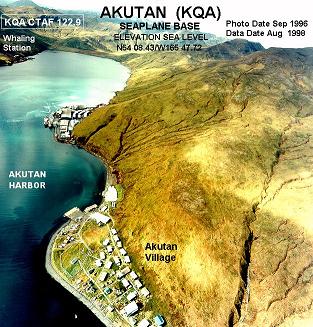
Akutan Seaplane Base is a public use seaplane base located in Akutan, a city on Akutan Island in the Aleutians East Borough of the U.S. state of Alaska. Scheduled seaplane service was subsidized by the Essential Air Service program until late 2012 when PenAir retired their Grumman Goose amphibious aircraft and a new land-based airport on neighboring Akun Island was built. The new airport is known as Akutan Airport.
The Krenitzin Islands are a group of small islands located in the eastern portion of the Fox Islands group of the eastern Aleutian Islands, Alaska. The Krenitizins are situated between Unalaska Island to the southwest and Unimak Island to the northeast. Named islands in the Krenitzins group include Aiktak, Avatanak, Derbin, Kaligagan Island (Qisĝagan), Rootok (Aayux̂tax̂), Round, Tigalda, and Ugamak. All of these islands are managed as part of the Aleutian Islands Unit of the Alaska Maritime National Wildlife Refuge. The Krenitzins have a total land area of 61.596 sq.mi. (159.533 km2) and have no population.
Aiktak Island is one of the Krenitzin Islands, a subgroup of the Fox Islands in the eastern Aleutian Islands in the U.S. state of Alaska. It is 1.3 miles (2.1 km) long and is located 38 miles (61 km) east of Akutan Island. Aiktak is an Aleut name transcribed by Captain Tebenkov in 1852 as "Ostrov Aikhtak". R.H. Geoghegan suggested that the name is derived from the Aleut "aikhag", meaning "travel or going on a voyage". It is also known as Ashmiak.
Avatanak Island is the second-largest of the Krenitzin Islands, a subgroup of the Fox Islands in the eastern Aleutian Islands in the U.S. state of Alaska. It lies southeast of Akun Island, across the Avatanak Strait. Within the Krenitzin Islands, it lies between Rootok Island (Aayux̂tax̂) to the west, and Tigalda Island to the east.
Tigalda Island is one of the Krenitzin Islands, a subgroup of the Fox Islands in the eastern Aleutian Islands, Alaska. Tigalda is located about 19 miles (31 km) east of Akutan Island, is 12 miles (19 km) long and has an area of about 35 square miles (91 km2). Tigalda is an Aleut name published by Captain Lutke (1836). It was called "Kagalga" by Captain Lt. Krenitzin and Lt. Levashev (1768). Tigalda Bay is situated on the north side of Tigalda. Father Veniaminov (1840) reported the existence of an Aleut village, which he called "Tigaldinskoe", of 91 people in 1833.

Ugamak Island is one of the Krenitzin Islands, a subgroup of the Fox Islands group of the eastern Aleutian Islands, Alaska. Ugamak is an Aleut word transcribed by Father Veniaminov (1840) which, according to R. H. Geoghegan, may mean "ceremony island". It is 5.9 miles (9.5 km) long and is located 32 miles (51 km) east of Akutan Island. Ugamak Bay is situated on the southeast coast of Ugamak, and Ugamak Strait is a three-mile-wide channel that separates Ugamak from Kaligagan Island to the west.
Poa Island is an islet located about 0.99 miles (1.59 km) off the south coast of Akun Island in the Fox Islands group of the eastern Aleutian Islands, Alaska. The island is 0.62 miles (1.00 km) long and reaches a maximum elevation of about 200 feet (61 m) above sea level. It was named for a genus of grasses in 1888 by the U.S. Bureau of Fisheries. Captain Tebenkov (1852) called it "Ostrov Tumannyi," meaning "foggy island."
Unalga Island is one of the Fox Islands subgroup of the Aleutian Islands of southwestern Alaska, United States. It lies just northeast of Unalaska Island and across Akutan Pass from Akutan Island to its northeast. It is the westernmost island in the Aleutians East Borough. Unalga Island has a land area of 11.004 square miles and is unpopulated. The island is 6.7 kilometres (4.2 mi) long and 8.2 kilometres (5.1 mi) wide.
Akutan Island is an inhabited island in the Fox Islands group of the eastern Aleutian Islands in the Aleutians East Borough of Alaska.

The Aleutian Islands —also called the Aleut Islands, Aleutic Islands, or, before 1867, the Catherine Archipelago—are a chain of 14 main, larger volcanic islands and 55 smaller ones. Most of the Aleutian Islands belong to the U.S. state of Alaska, with the archipelago encompassing the Aleutians West Census Area and the Aleutians East Borough. The Commander Islands, located further to the west, belong to the Russian federal subject of Kamchatka Krai, of the Russian Far East. The islands form part of the Aleutian Arc of the Northern Pacific Ocean, and occupy a land area of 6,821 sq mi (17,666 km2) that extends westward roughly 1,200 mi (1,900 km) from the Alaskan Peninsula mainland, in the direction of the Kamchatka Peninsula; the archipelago acts as a border between the Bering Sea to the north and the Pacific Ocean to the south. Crossing longitude 180°, at which point east and west longitude end, the archipelago contains both the westernmost and easternmost parts of the United States, by longitude. The westernmost U.S. island, in real terms, however, is Attu Island, west of which runs the International Date Line.
Akutan Airport is a state-owned public-use airport serving Akutan, a city on Akutan Island in the Aleutians East Borough of the U.S. state of Alaska. The airport is located on Akun Island, 6 miles (10 km) east of Akutan Island. Scheduled air service is subsidized by the Essential Air Service program.

Isanotski Strait is a strait connecting the northern Gulf of Alaska with the Bering Sea, in the U.S. state of Alaska. Isanax̂ is the Aleut name for present day Isanotski Strait, and means gap, hole, rent, or tear in the Aleut language which was rendered as Isanotski in transliterated Russian. The strait appears as Исанакъ in 1802 and Исаноцкый in 1844 on Russian maps.