
Umnak is one of the Fox Islands of the Aleutian Islands. With 686.01 square miles (1,776.76 km2) of land area, it is the third largest island in the Aleutian archipelago and the 19th largest island in the United States. The island is home to a large volcanic caldera on Mount Okmok and the only field of geysers in Alaska. It is separated from Unalaska Island by Umnak Pass. In 2000, Umnak was permanently inhabited by only 39 people.

The Commander Islands, Komandorski Islands, or Komandorskie Islands are a group of treeless, sparsely populated islands in the Bering Sea located about 175 kilometres (109 mi) east of the Kamchatka Peninsula in the Russian Far East. The islands consist of Bering Island, Medny Island and fifteen smaller ones, the largest of which are Tufted Puffin Rock , 15 hectares, and Kamen Ariy, which are between 3 kilometres (1.9 mi) and 13 kilometres (8.1 mi) west of the only settlement, Nikolskoye. Administratively, they compose Aleutsky District of Kamchatka Krai in Russia.

The Andreanof Islands are a group of islands in the Aleutian Islands in southwestern Alaska. They are located at about 52° North and 172°57' to 179°09' West.

Kanaga Island is a part of the Andreanof Islands group of the Aleutian Islands in Alaska. The island measures 30 miles (48 km) long and between 4–8 miles (6.4–12.9 km) wide with an area of 142 sq mi (368 km2), making it the 42nd largest island in the United States. The island's most notable feature is Mount Kanaga, a 4,288-foot-high (1,307 m) volcano which last erupted in 1995.
Khvostof Island or Atanak is an island in the Rat Islands archipelago of the Western Aleutian Islands, Alaska. The island is 2 kilometres (1.2 mi) long and 2.74 kilometres (1.70 mi) wide.
Amatignak Island is a member of the Delarof Islands, in Alaska's Aleutian archipelago. The southernmost point of Alaska is on this island, as well as the westernmost longitude of Alaska, the United States, and North America.
The Delarof Islands are a group of small islands at the extreme western end of the Andreanof Islands group in the central Aleutian Islands, Alaska. The Delarofs consist of 11 named islands: Amatignak, Gareloi, Ilak, Kavalga (Qavalĝa), Ogliuga (Aglaga), Skagul (Sxaĝulax̂), the Tag (Tagachaluĝis), Tanadak (Tanaadax̂), Ugidak (Qagan-tanax̂), Ulak, and Unalga (Unalĝa).
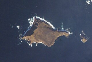
Aiktak Island is one of the Krenitzin Islands, a subgroup of the Fox Islands in the eastern Aleutian Islands in the U.S. state of Alaska. It is 1.3 miles (2.1 km) long and is located 38 miles (61 km) east of Akutan Island. Aiktak is an Aleut name transcribed by Captain Tebenkov in 1852 as "Ostrov Aikhtak." R. H. Geoghegan suggested that the name is derived from the Aleut "aikhag", meaning "travel or going on a voyage." It is also known as Ashmiak.
Chugul is a small island located in the centre of the Andreanof Islands of the Aleutian Islands of Alaska. It is one a group of small islands that are situated between Adak Island and Atka Island. Nearby islands include Igitkin and Tagalak. It length is 7.5 kilometres (4.7 mi) and width is 5.7 kilometres (3.5 mi).
Great Sitkin Island is a volcanic island in the Andreanof Islands of the Aleutian Islands of Alaska. The island covers a total area of 60 square miles (160 km2) and lies slightly north of a group of islands which are located between Adak Island and Atka Island.
Little Tanaga Island is an island located in the Andreanof Islands of the Aleutian Islands of Alaska. It lies between Kagalaska Island and Umak Island. The island is 12.5 kilometres (7.8 mi) long and 16.3 kilometres (10.1 mi) wide.
Tagalak Island is an island located in the central area of the Andreanof Islands of the Aleutian Islands of Alaska. West of the island lies Chugul. The island is 6.3 kilometres (3.9 mi) long and 7 kilometres (4.3 mi) wide.
Ulak Island is an island in the Delarof Islands subgroup of the Andreanof Islands in the Aleutian Islands chain of Alaska.
Umak Island is an island lying in a group of small islands situated between Adak Island and Atka Island in the Andreanof Islands group of the Aleutian Islands of Alaska. It is 11.7 kilometres long and 7.8 kilometres wide.
Unalga Island is one of the Fox Islands subgroup of the Aleutian Islands of southwestern Alaska, United States. It lies just northeast of Unalaska Island and across Akutan Pass from Akutan Island to its northeast. It is the westernmost island in the Aleutians East Borough. Unalga Island has a land area of 11.004 square miles and is unpopulated. The island is 6.7 kilometres (4.2 mi) long and 8.2 kilometres (5.1 mi) wide.
Akun Island is one of the Fox Islands subgroup of the Aleutian Islands in the Aleutians East Borough of southwestern Alaska.
Egg Island is a small island in the Fox Islands subgroup of the Aleutian Islands in the U.S. state of Alaska. It lies off the eastern end of Unalaska Island and just off the northeastern tip of Sedanka Island. It is the easternmost island in the Aleutians West Census Area of Alaska. The island has a land area of 311.12 acres (1.259 km²) and is uninhabited. It is 19.3 kilometres (12.0 mi) long and 12 kilometres (7.5 mi) wide.

Tanaga Island is an island in the western Andreanof Islands, in the southwest part of the Aleutian Islands, Alaska. The island has a land area of 204 square miles, making it the 33rd largest oceanic island in the United States. Its highest point is volcano Mount Tanaga at 5,925 feet.
Herbert Island is an island in the Islands of Four Mountains subgroup of the Aleutian archipelago. It is 3.1 miles (5.0 km) from Chuginadak Island, separated by the Chuginadak Pass. Yunaska Island is 16 miles (26 km) northwest of Herbert Island. Measuring 6.2 miles (10.0 km) across, Herbert Island is somewhat circular in shape and is covered by the 4,200-foot (1,300 m) Herbert Volcano, whose 2-kilometre (1.2 mi) wide caldera is one of the largest in the Aleutian Islands. There have been no recorded eruptions here.

Unalaska is a volcanic island in the Fox Islands group of the Aleutian Islands in the US state of Alaska located at 53°38′N167°00′W. The island has a land area of 1,051 square miles (2,720 km2). It measures 79.4 mi (127.8 km) long and 34.7 mi (55.8 km) wide. The city of Unalaska, Alaska, covers part of the island and all of neighboring Amaknak Island where the Port of Dutch Harbor is located. The population of the island excluding Amaknak as of the 2000 census was 1,759 residents.

