
Sand Point, also known as Popof Island, is a city in Aleutians East Borough, Alaska, United States. At the 2010 census the population was 976, up from 952 in 2000, but by the 2020 Census this had reduced to 578. It is on northwestern Popof Island, one of the Shumagin Islands, off the Alaska Peninsula. It is the borough seat of Aleutians East Borough, and is near the entrance to the Bering Sea.

Atka is a small city located on the east side of Atka Island, in Aleutians West Census Area, Alaska, United States. The population was 53 at the 2020 census, down from 61 in 2010.

Nikolski is a census-designated place (CDP) on Umnak Island in Aleutians West Census Area, Alaska, United States. The population was 39 at the 2020 census, up from 18 in 2010. Nikolski is on Nikolski Bay, off the southwest end of the island. It is 116 air miles west of Unalaska, and 900 air miles from Anchorage. Residents are known as Unangan, and Aleut is spoken in most of the remaining homes.

Attu is an island in the Near Islands. It is one of the westernmost points of the U.S. state of Alaska. The island became uninhabited in 2010, making it the largest uninhabited island that is part of the United States politically.

Unimak Island is the largest island in the Aleutian Islands chain of the U.S. state of Alaska.
Umnak is one of the Fox Islands of the Aleutian Islands. With 686.01 square miles (1,776.76 km2) of land area, it is the third largest island in the Aleutian archipelago and the 19th largest island in the United States. The island is home to a large volcanic caldera on Mount Okmok and the only field of geysers in Alaska. It is separated from Unalaska Island by Umnak Pass. In 2000, Umnak was permanently inhabited by only 39 people and by 2010, around 18, placing the settlement of Nikolski in difficulty and its school was closed.

Atka Island is the largest island in the Andreanof Islands of the Aleutian Islands of Alaska. The island is 50 miles (80 km) east of Adak Island. It is 65 miles (105 km) long and 2–20 miles (3–30 km) wide with a land area of 404.6 square miles (1,048 km2), making it the 22nd largest island in the United States. The northeast of Atka Island contains the Korovin volcano which reaches a peak of 5,030 feet (1,533 m). Oglodak Island is located 3.4 miles off Cape Kigun, Atka's westernmost point.

The Andreanof Islands are a group of islands in the Aleutian Islands in southwestern Alaska, United States. They are located at about 52° North and 172°57' to 179°09' West.
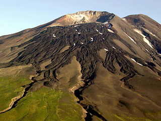
Kanaga Island is a part of the Andreanof Islands group of the Aleutian Islands in Alaska. The island measures 30 miles (48 km) long and between 4–8 miles (6.4–12.9 km) wide with an area of 142 sq mi (368 km2), making it the 42nd largest island in the United States. The island's most notable feature is Mount Kanaga, a 4,288-foot-high (1,307 m) volcano which last erupted in 1995.

Agattu is an island in Alaska, part of the Near Islands in the western end of the Aleutian Islands. With a land area of 85.558 square miles (221.59 km2) Agattu is one of the largest uninhabited islands in the Aleutians. It is the second largest of the Near Islands, after Attu Island. It is volcanic and considerably mountainous. The treeless island has a tundra-like terrain which reaches a peak of 2,073 feet (632 m) above sea level. Its length is 19 miles (30 km) and width is 12.2 miles (19.7 km).
Samalga Island is the westernmost island in the Fox Islands group of the eastern Aleutian Islands, Alaska. It is 5.36 miles (8.63 km) long and is situated at the southwestern tip of Umnak Island. It has a land area of 1.589 square miles (4.12 km2) and is uninhabited. It is separated from the Islands of Four Mountains group to the west by the Samalga Pass. Samalga is the farthest point west on the Aleutian Island chain that still keeps the Alaska UTC−9 time zone. It is also the closest Alaskan island to Hawaii.

Sedanka Island is an island in the Fox Islands group of the eastern Aleutian Islands, Alaska. It is 10.3 miles (16.6 km) long and is situated off the northeast coast of Unalaska Island. It has a land area of 39.889 square miles (103.31 km2) and no permanent population.
Gareloi or Anangusook is a volcanic island in the Delarof Islands of the Aleutian Islands of Alaska. It is located between the Tanaga Pass and the Amchitka Pass.
Chuginadak Island is the largest island in the Islands of Four Mountains subgroup of the Aleutian archipelago. Chuginadak is an Aleutian name published by Captain Tebenkov in an 1852 map. According to Knut Bergsland's Aleut Dictionary, the Aleutian word "chugida-lix" means "to fry, to make sizzle." The Western half of the island is called Chuginadax in Aleut, meaning 'simmering'.

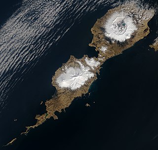
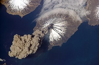
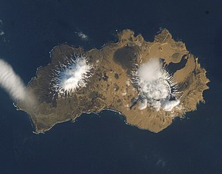
The Islands of Four Mountains is an island grouping of the Aleutian Islands in Alaska, United States. The chain includes, from west to east, Amukta, Chagulak, Yunaska, Herbert, Carlisle, Chuginadak, Uliaga, and Kagamil islands. This island chain is located between Amukta Pass and the Andreanof Islands to the west, and Samalga Pass and the Fox Islands to the east. These islands have a total land area of 210.656 sq mi (545.596 km2) and have no permanent population. The two largest islands are Yunaska and Chuginadak. Chuginadak is mainly made up of the active volcano Mount Cleveland.

Popof Island is an island in the Shumagin Islands south of mainland Alaska. The largest community in the area, Sand Point, is located on the northwest coast. Popof Island is 10 miles (16 km) long, 5 miles (8.0 km) wide and the peak elevation is 1,550 feet. It is located at 55°18′49″N160°22′29″W. It has a land area of 93.651 km2 and a total population of 578 persons at the 2020 census.
Yunaska is an uninhabited island which is the largest of the Islands of Four Mountains group in the Aleutian Islands of southwestern Alaska, United States. It has a land area of 66.834 square miles according to the 2000 census.
Unalga Island is one of the Fox Islands subgroup of the Aleutian Islands of southwestern Alaska, United States. It lies just northeast of Unalaska Island and across Akutan Pass from Akutan Island to its northeast. It is the westernmost island in the Aleutians East Borough. Unalga Island has a land area of 11.004 square miles and is unpopulated. The island is 6.7 kilometres (4.2 mi) long and 8.2 kilometres (5.1 mi) wide.

Unalaska is a volcanic island in the Fox Islands group of the Aleutian Islands in the US state of Alaska located at 53°38′N167°00′W. The island has a land area of 1,051 square miles (2,720 km2). It measures 79.4 mi (127.8 km) long and 34.7 mi (55.8 km) wide. The city of Unalaska, Alaska, covers part of the island and all of neighboring Amaknak Island where the Port of Dutch Harbor is located. The population of the island excluding Amaknak as of the 2000 census was 1,759 residents.

The Aleutian Islands —also called the Aleut Islands, Aleutic Islands, or, before 1867, the Catherine Archipelago—are a chain of 14 main, larger volcanic islands and 55 smaller ones. Most of the Aleutian Islands belong to the U.S. state of Alaska, with the archipelago encompassing the Aleutians West Census Area and the Aleutians East Borough. The Commander Islands, located further to the west, belong to the Russian federal subject of Kamchatka Krai, of the Russian Far East. The islands form part of the Aleutian Arc of the Northern Pacific Ocean, and occupy a land area of 6,821 sq mi (17,666 km2) that extends westward roughly 1,200 mi (1,900 km) from the Alaskan Peninsula mainland, in the direction of the Kamchatka Peninsula; the archipelago acts as a border between the Bering Sea to the north and the Pacific Ocean to the south. Crossing longitude 180°, at which point east and west longitude end, the archipelago contains both the westernmost and easternmost parts of the United States, by longitude. The westernmost U.S. island, in real terms, however, is Attu Island, west of which runs the International Date Line.
