
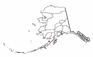
The Pribilof Islands are a group of four volcanic islands off the coast of mainland Alaska, in the Bering Sea, about 200 miles (320 km) north of Unalaska and 200 miles (320 km) southwest of Cape Newenham. The Siberian coast is roughly 500 miles (800 km) northwest. About 77 square miles (200 km2) in total area, they are mostly rocky and are covered with tundra, with a population of 572 as of the 2010 census.

Aleutians East Borough is a 2nd class borough in the U.S. state of Alaska. As of the 2020 census the borough's population was 3,420. The borough seat is Sand Point.

Bethel Census Area is a census area in the U.S. state of Alaska. As of the 2020 census, the population is 18,666, up from 17,013 in 2010. It is part of the unorganized borough and therefore has no borough seat. Its largest community is the city of Bethel, which is also the largest city in the unorganized borough.

Dillingham Census Area is a census area located in the state of Alaska, United States. At the 2020 census, the population was 4,857, slightly up from 4,847 in 2010. It is part of the unorganized borough and therefore has no borough seat. Its largest community by far is the city of Dillingham, on a small arm of Bristol Bay on the Bering Sea.
Nome Census Area is a census area located in the U.S. state of Alaska, mostly overlapping with the Seward Peninsula. As of the 2020 census, the population was 10,046, up from 9,492 in 2010. It is part of the unorganized borough and therefore has no borough seat. Its largest community by far is the city of Nome.
Nelson Lagoon is a census-designated place (CDP) in Aleutians East Borough, Alaska, United States. At the 2020 census the population was 41, down from 52 in 2010 and 83 in 2000.

St. George is a city in Aleutians West Census Area, Alaska, United States. At the 2010 census the population was 102, down from 152 in 2000. It is the main settlement of St. George Island in the Pribilofs, a small island group in the Bering Sea.
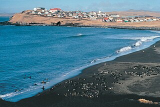
St. Paul is a city in the Aleutians West Census Area, Alaska, United States. It is the main settlement of Saint Paul Island in the Pribilofs, a small island group in the Bering Sea. Saint Paul Island is well known as a birdwatching haven. The population was 479 at the 2010 census, down from 532 in 2000.

Napakiak is a city in Bethel Census Area, Alaska, United States. At the 2010 census the population was 354, up one resident from 353 since 2000.
Ugashik is a census-designated place (CDP) in Lake and Peninsula Borough, Alaska, United States. The population was 4 at the 2020 census, down from 12 in 2010.
Koyuk is a city in the Nome Census Area, Alaska, United States. The population was 332 at the 2010 census, up from 297 in 2000.

Shaktoolik is a city in Nome Census Area, Alaska, United States. At the 2010 census the population was 251, up from 230 in 2000. Shaktoolik is one of a number of Alaskan communities threatened by erosion and related global warming effects. The community has been relocated twice.
St. Michael, historically referred to as Saint Michael, is a city in Nome Census Area, Alaska. The population was 401 at the 2010 census, up from 368 in 2000.

Unalakleet is a city in Nome Census Area, Alaska, United States, in the western part of the state. At the 2010 census the population was 688, down from 747 in 2000. Unalakleet is known in the region and around Alaska for its salmon and king crab harvests; the residents rely for much of their diet on caribou, ptarmigan, oogruk, and various salmon species.

St. Lawrence Island is located west of mainland Alaska in the Bering Sea, just south of the Bering Strait. The village of Gambell, located on the northwest cape of the island, is 50 nautical miles from the Chukchi Peninsula in the Russian Far East. The island is part of Alaska, but closer to Russia and Asia than to the Alaskan and North American mainland. St. Lawrence Island is thought to be one of the last exposed portions of the land bridge that once joined Asia with North America during the Pleistocene period. It is the sixth largest island in the United States and the 113th largest island in the world. It is considered part of the Bering Sea Volcanic Province. The Saint Lawrence Island shrew is a species of shrew endemic to St. Lawrence Island. The island is jointly owned by the predominately Siberian Yupik villages of Gambell and Savoonga, the two main settlements on the island.

The Alaska Maritime National Wildlife Refuge is a United States National Wildlife Refuge comprising 2,400 islands, headlands, rocks, islets, spires and reefs in Alaska, with a total area of 4.9 million acres (20,000 km2), of which 2.64 million acres (10,700 km2) is wilderness. The refuge stretches from Cape Lisburne on the Chukchi Sea to the tip of the Aleutian Islands in the west and Forrester Island in the southern Alaska Panhandle region in the east. The refuge has diverse landforms and terrains, including tundra, rainforest, cliffs, volcanoes, beaches, lakes, and streams.

St. Matthew Island is an uninhabited, remote island in the Bering Sea in Alaska, 183 miles (295 km) west-northwest of Nunivak Island. The entire island's natural scenery and wildlife is protected as it is part of the Bering Sea unit of the Alaska Maritime National Wildlife Refuge.

Southwest Alaska is a region of the U.S. state of Alaska. The area is not exactly defined by any governmental administrative region(s); nor does it always have a clear geographic boundary.
Sledge Island, or Ayak Island, is a small island in the Bering Sea. It is located 5.3 mi (8.5 km) from the southwestern shore of the Seward Peninsula, off the shores of Alaska.

The Aleutian Islands, also called the Aleut Islands or Aleutic Islands and known before 1867 as the Catherine Archipelago, are a chain of 14 large volcanic islands and 55 smaller islands. Most of the Aleutian Islands belong to the U.S. state of Alaska, but some belong to the Russian federal subject of Kamchatka Krai. They form part of the Aleutian Arc in the Northern Pacific Ocean, occupying a land area of 6,821 sq mi (17,666 km2) and extending about 1,200 mi (1,900 km) westward from the Alaska Peninsula toward the Kamchatka Peninsula in Russia, and act as a border between the Bering Sea to the north and the Pacific Ocean to the south. Crossing longitude 180°, at which point east and west longitude end, the archipelago contains both the westernmost part of the United States by longitude and the easternmost by longitude. The westernmost U.S. island in real terms, however, is Attu Island, west of which runs the International Date Line. While nearly all the archipelago is part of Alaska and is usually considered as being in the "Alaskan Bush", at the extreme western end, the small, geologically related Commander Islands belong to Russia.
