Amaknak Island (Russian : Амакнак) or Umaknak Island (Aleut : Amaxnax̂; [1] Russian : Умакнак) is the most populated island in the Aleutian Islands, an archipelago which is part of the U.S. state of Alaska.
Amaknak Island (Russian : Амакнак) or Umaknak Island (Aleut : Amaxnax̂; [1] Russian : Умакнак) is the most populated island in the Aleutian Islands, an archipelago which is part of the U.S. state of Alaska.
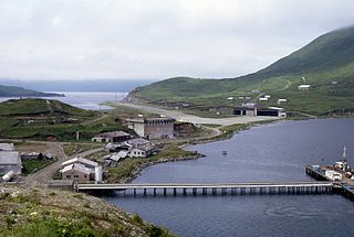
Amaknak is an islet of the Fox Islands archipelago, a portion of the Aleutian Islands, in the Aleutians West Census Area of southwestern Alaska. Amaknak Island is located within Unalaska Bay, an inlet of the Bering Sea on the northeast side of Unalaska Island. At their closest point—the channel that leads from Unalaska Bay to Iliuliuk Harbor—the two islands are only about 200 feet (61 meters) apart. There is a 500-foot (152-meter) bridge joining the islands at another close point, where Iliuliuk Harbor connects with Captains Bay.
Amaknak's land area is 3.3 sq mi (8.5 km2), which is dwarfed by its neighbor Unalaska Island, which has a land area of 1,051 sq. miles (2,722 km2). The highest point on Amaknak is Mount Ballyhoo.
Despite its small size, Amaknak is the most populous of all the islands of the Aleutians chain, with 2,524 residents as of the 2000 census. Though located within the boundaries of the City of Unalaska, the inhabitants of Amaknak generally regard themselves as residents of Dutch Harbor, which is the portion of the City of Unalaska located on Amaknak Island. (The remaining 41% of Unalaska's residents live on Unalaska Island.) [2]

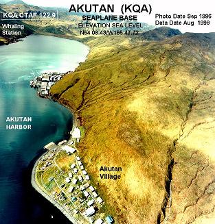
Akutan is a city on Akutan Island in the Aleutians East Borough of the Aleutian Islands in Alaska, United States. The population was 1,589 at the 2020 census, up from 1,027 in 2010, making it the 4th fastest-growing city of the decade in Alaska. Akutan Harbor is adjacent.

Sand Point, also known as Popof Island, is a city in Aleutians East Borough, Alaska, United States. At the 2010 census the population was 976, up from 952 in 2000, but by the 2020 Census this had reduced to 578. It is on northwestern Popof Island, one of the Shumagin Islands, off the Alaska Peninsula. It is the borough seat of Aleutians East Borough, and is near the entrance to the Bering Sea.

Nikolski is a census-designated place (CDP) on Umnak Island in Aleutians West Census Area, Alaska, United States. The population was 39 at the 2020 census, up from 18 in 2010. Nikolski is on Nikolski Bay, off the southwest end of the island. It is 116 air miles west of Unalaska, and 900 air miles from Anchorage. Residents are known as Unangan, and Aleut is spoken in most of the remaining homes.

The City of Unalaska is the main population center in the Aleutian Islands. The city is in the Aleutians West Census Area, a regional component of the Unorganized Borough in the U.S. state of Alaska. Unalaska is located on Unalaska Island and neighboring Amaknak Island in the Aleutian Islands off mainland Alaska. The population was 4,254 at the 2020 census, which is 81% of the entire Aleutians West Census Area. Unalaska is the second largest city in the Unorganized Borough, behind Bethel.

Dutch Harbor is a harbor on Amaknak Island in Unalaska, Alaska. It was the location of the Battle of Dutch Harbor in June 1942 and was one of the few sites in the United States to be subjected to aerial bombardment by a foreign power during World War II. It was also one of the few sites, besides the attack on Pearl Harbor in Hawaii, in incorporated U.S. territory to be bombed by the Japanese in the war.
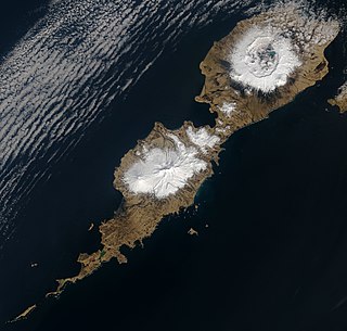
The Fox Islands are a group of islands in the eastern Aleutian Islands of the U.S. state of Alaska. The Fox Islands are the closest to mainland North America in the Aleutian chain, and just east of Samalga Pass and the Islands of Four Mountains group.

Umnak is one of the Fox Islands of the Aleutian Islands. With 686.01 square miles (1,776.76 km2) of land area, it is the third largest island in the Aleutian archipelago and the 19th largest island in the United States. The island is home to a large volcanic caldera on Mount Okmok and the only field of geysers in Alaska. It is separated from Unalaska Island by Umnak Pass. In 2000, Umnak was permanently inhabited by only 39 people and by 2010, around 18, placing the settlement of Nikolski in difficulty and its school was closed.

The Makushin Volcano is an ice-covered stratovolcano located on Unalaska Island in the Aleutian Islands of the U.S. state of Alaska. With an elevation of 2,036 meters (6,680 ft), its summit is the highest point on the island. Makushin is one of the most active among the 52 historically active volcanoes of Alaska. It has erupted at least two dozen times over the past several thousand years, with the last eruption occurring in 1995.

Sedanka Island is an island in the Fox Islands group of the eastern Aleutian Islands, Alaska. It is 10.3 miles (16.6 km) long and is situated off the northeast coast of Unalaska Island. It has a land area of 39.889 square miles (103.31 km2) and no permanent population.

Tom Madsen Airport is a state-owned public-use airport in City of Unalaska, on Amaknak Island in the Aleutian Islands, off the coast of the U.S. state of Alaska. It is located near the Bering Sea coast of Unalaska Island, 800 miles (1,300 km) southwest of Anchorage and 1,950 miles (3,140 km) from Seattle.

Southwest Alaska is a region of the U.S. state of Alaska. The area is not exactly defined by any governmental administrative region(s); nor does it always have a clear geographic boundary.
Unalga Island is one of the Fox Islands subgroup of the Aleutian Islands of southwestern Alaska, United States. It lies just northeast of Unalaska Island and across Akutan Pass from Akutan Island to its northeast. It is the westernmost island in the Aleutians East Borough. Unalga Island has a land area of 11.004 square miles and is unpopulated. The island is 6.7 kilometres (4.2 mi) long and 8.2 kilometres (5.1 mi) wide.
Egg Island is a small island in the Fox Islands subgroup of the Aleutian Islands in the U.S. state of Alaska. It lies off the eastern end of Unalaska Island and just off the northeastern tip of Sedanka Island. It is the easternmost island in the Aleutians West Census Area of Alaska. The island has a land area of 311.12 acres (1.2591 km2) and is uninhabited.

The Dutch Harbor Naval Operating Base and Fort Mears were the two military installations built next to each other in Dutch Harbor, on Amaknak Island of the Aleutian Islands in Alaska, by the United States in response to the growing war threat with Imperial Japan during World War II. In 1938, the Navy Board recommended the construction which began in July 1940. The first United States Army troops arrived in June 1941 and an air base constructed by the United States Navy was finished in September 1941. At the time of the surprise attack on Pearl Harbor, these were the only military installations in the Aleutian Islands.

Unalaska is a volcanic island in the Fox Islands group of the Aleutian Islands in the US state of Alaska located at 53°38′N167°00′W. The island has a land area of 1,051 square miles (2,720 km2). It measures 79.4 mi (127.8 km) long and 34.7 mi (55.8 km) wide. The city of Unalaska, Alaska, covers part of the island and all of neighboring Amaknak Island where the Port of Dutch Harbor is located. The population of the island excluding Amaknak as of the 2000 census was 1,759 residents.
The Ounalashka Corporation is the native village corporation for the Aleuts of Unalaska and Amaknak Islands, in the Aleutian Islands. Like its parent entity, the Aleut Corporation, it was formed as a result of the Alaska Native Claims Settlement Act of 1971. Its headquarters are located in Unalaska, Alaska.

The Aleutian Islands —also called the Aleut Islands, Aleutic Islands, or, before 1867, the Catherine Archipelago—are a chain of 14 main, larger volcanic islands and 55 smaller ones. Most of the Aleutian Islands belong to the U.S. state of Alaska, with the archipelago encompassing the Aleutians West Census Area and the Aleutians East Borough. The Commander Islands, located further to the west, belong to the Russian federal subject of Kamchatka Krai, of the Russian Far East. The islands form part of the Aleutian Arc of the Northern Pacific Ocean, and occupy a land area of 6,821 sq mi (17,666 km2) that extends westward roughly 1,200 mi (1,900 km) from the Alaskan Peninsula mainland, in the direction of the Kamchatka Peninsula; the archipelago acts as a border between the Bering Sea to the north and the Pacific Ocean to the south. Crossing longitude 180°, at which point east and west longitude end, the archipelago contains both the westernmost and easternmost parts of the United States, by longitude. The westernmost U.S. island, in real terms, however, is Attu Island, west of which runs the International Date Line.

The Unalaska Formation is a Miocene Era geologic formation on Amaknak Island and Unalaska Island, in the Aleutian Islands archipelago of southwestern Alaska.

Unalaska Bay is a waterway of Unalaska Island in the U.S. state of Alaska. It is situated below the eastern slopes of Makushin Volcano. Composed of seven individual bays, Unalaska Bay opens onto the Bering Sea.

Mount Newhall is a 1,916-foot-elevation (584-meter) summit in Alaska, United States.
53°54′37″N166°32′12″W / 53.91028°N 166.53667°W