Unalaska Bay

Last updated
Unalaska Bay
Unalaska 2.09.jpg
Broad Bay and the Makushin Volcano partly hidden by low clouds and the Makushin valley.
Relief map of USA Alaska.png
Red pog.svg
Unalaska Bay
Coordinates 53°56′55″N166°29′54″W / 53.94861°N 166.49833°W / 53.94861; -166.49833 Coordinates: 53°56′55″N166°29′54″W / 53.94861°N 166.49833°W / 53.94861; -166.49833
Type Bay
Ocean/sea sources Pacific Ocean
Basin  countries United States
Max. lengthn/a
Max. widthn/a
Surface arean/a
Settlements Dutch Harbor
Unalaska
The East Channel separates Unalaska Island, with the fishing boats berthed, from Amaknak Island. On the right side is Iliukliuk Harbor, the South Channel and Captains Bay in the background. Unalaska 2.02.jpg
The East Channel separates Unalaska Island, with the fishing boats berthed, from Amaknak Island. On the right side is Iliukliuk Harbor, the South Channel and Captains Bay in the background.

Unalaska Bay is a waterway of Unalaska Island in the U.S. state of Alaska. It is situated below the eastern slopes of Makushin Volcano. Composed of seven individual bays, Unalaska Bay opens onto the Bering Sea. [1]

Contents

Description

Dutch Harbor from outer space. Dutch Harbor, Alaska.jpg
Dutch Harbor from outer space.

Unalaska Bay is the general name of the indentation making in to the north end of Unalaska Island between Cape Kalekhta and Cape Cheerful. Commercially, it was the most important bay in western Alaska in the beginning of the 20th century. Its shores are generally mountainous with precipitous sea faces. Amaknak Island lies in its southern end. Westward of the island the water is deep, but there is no good harbor in this part of the bay; eastward of the island are the important anchorages of Dutch Harbor, Iliuliuk Bay, and Iliuliuk Harbor. The channel to Iliuliuk Bay and Dutch Harbor is free from dangers except along the shores. Iliuliuk Harbor is obstructed at its entrance by ledges. [2]

Cape Cheerful, the western point at the entrance to Unalaska Bay, is made up of bold, very high headlands, rounded on top, and intersected by deep, grassy valleys. The shore is free from dangers and has deep water close-to. A cascade, 125 feet high, south of Cape Cheerful, is a conspicuous mark from the vicinity of Cape Kalekhta, and is useful in thick weather when only the lower part of the land can be seen.

Ulakhta Head, 900 feet high, the north end of Amaknak Island, is, in clear weather, one of the best landmarks for fixing the position of Unalaska Bay. In appearance it is like a pyramid with the top cut off. The top shows perfectly flat, and there is no other headland or mountain in this vicinity that has this feature. It is not as high as the background, but shows up well against it, and can be made out at a long distance from the bay. From its northwest point a reef extends off | mile, marked by Needle Rock, similar in appearance to Priest Rock, but not so large. From its northeast point a long, narrow sand spit extends to the southward l£ miles; its southern end, called Spithead, is marked by a beacon, about 15 feet high, standing close to its southern shore.

Princess Head, 2 miles from Cape Kalekhta, is a large square-headed rock that projects from the shore far enough to be distinctly observed, even in thick weather, in following along the east shore.

Constantine Bay, about 4 miles from Cape Kalekhta, is obstructed by numerous rocky ledges, many of which are only evident from the attached kelp. It is of no importance and should be avoided by all vessels.

Summer Bay, the large, shallow bight, 3 miles from Constantine Bay and opposite Ulakhta Head, is shoal, and its shores are lined with kelp-marked rocks and ledges. At its southern headland is Pinnacle Rock, about 60 feet high. This bay is an excellent place to seine for salmon. The bay should be avoided by vessels.

Iliuliuk Bay extends from Pinnacle Rock and Ulakhta Head to Iliuliuk. To the northward of Spithead there is a ridge extending across the bay, having a least depth of 10 fathoms. South of this ridge the depths increase to 16 and 19 fathoms. There is anchorage anywhere in the bay. The usual anchorage is at the head in 14 to 16 fathoms, muddy bottom, where, even with northerly winds, the force of the sea does not seem to reach home. At the head of Iliuliuk Bay, behind the village, there is a distinct ravine or break in the mountains, which extends through to the water to the southward. This is a useful guide for entering the bay and inner harbor.

The portion south-southwestward of Amaknak Island is the long narrow inlet of Captains Bay. There is a narrow passage from it to Iliuliuk Harbor. On the western side of Unalaska Bay are Nateekin Bay, Broad Bay, and Eider Point Anchorage. [3]

Sailing directions

When bound for Unalaska Bay from any part of Bering Sea, it is recommended to shape the course for Cape Cheerful. In thick weather it is better to fall to the westward of Cape Cheerful and then round it than to fall to the eastward of it and get down among the passes. Makushin Volcano, 5,474 feet high, can generally be seen in clear weather, and is very prominent. An extinct crater,

2,314 feet high, back of Cape Cheerful and west of Eider Point, gives a distinct point for which to steer until close enough to distinguish the surrounding features. On getting close to the island, when the fog hangs over the land but leaves a clear space just along the water's edge, Wislow Island forms a good landmark. It is a very small, rounded island, regular in shape, and stands off far enough from the land to be distinctly seen as not a part of the main island. To the westward, under similar conditions, Makushin Cape can be seen at times. The land slopes gently to the cape from Makushin Volcano, and ends in a small, peak-like formation at the end of the cape. From the eastward the cascade south of Cape Cheerful is also useful. Strangers, when in the vicinity and uncertain of the identity of the bay and its landmarks, should endeavor to pick out Ulakhta Head. Looking into the bay, its flat top breaking off abruptly to sloping sides presents an appearance unlike any other in the vicinity, and shows up well against the background of mountains.

Dangers

Navigators should avoid the kelp, which invariably indicates a rocky bottom. A large cluster of rocks, mostly awash, and usually marked by breakers, extends nearly 200 yards (180 m) to the westward of the south head of Constantine Bay. Pinnacle Rock is surrounded by reefs, awash and under water, for a distance of 300 yards (270 m). Between Pinnacle Rock and a point opposite the entrance to Dutch Harbor the east shore is lined with rocks, and should not be approached closer than 4 miles (6.4 km). The spit has a kelp-marked shoal on its east side which extends its whole length; at its middle point the shoal extends 4 miles (6.4 km) from shore. Spithead is bold-to, and may be safely approached as close as 150 yards (140 m). There is a beacon, about 15 feet high, standing close to its southern shore. Rocky Point has a kelp-marked reef which extends toward Spithead about 350 yards (320 m); eastward of the point shoal water makes out about 200 yards (180 m) with little kelp. The northern extremity of the reef is marked by a buoy painted white. From Rocky Point south, the shore of Amaknak Island should not be approached closer than 300 yards (270 m). Iliuliuk Reef consists of a ledge of rocks, portions of which are always exposed, extending in an east and west direction for 250 yards (230 m). From the eastern dry rock a ledge, marked by kelp, extends south by east-southeast 150 yards (140 m). The southern extremity of this ledge is sometimes marked by a buoy. Tuscarora Rock, marked by kelp, lies about 50 yards (46 m) south-southeast by east. from the southern extremity of Iliuliuk Reef. It is small and generally marked by an iron barrel buoy. These buoys were maintained by the Alaska Commercial Company.

Related Research Articles

Unalaska, Alaska City in Alaska, United States

Unalaska is the chief center of population in the Aleutian Islands. The city is in the Aleutians West Census Area, a regional component of the Unorganized Borough in the U.S. state of Alaska. Unalaska is located on Unalaska Island and neighboring Amaknak Island in the Aleutian Islands off mainland Alaska. The population was 4,376 at the 2010 census, which is 79% of the entire Aleutians West Census Area. Unalaska is the second largest city in the Unorganized Borough, behind Bethel.

Dutch Harbor Harbor in the United States

Dutch Harbor is a harbor on Amaknak Island in Unalaska, Alaska. It was the location of the Battle of Dutch Harbor in June 1942, and was one of the few sites in the United States to be subjected to aerial bombardment by a foreign power during World War II. It was also one of the few sites, besides the attack on Pearl Harbor in Hawaii, in incorporated U.S. territory to be bombed by the Japanese in the war.

Umnak Island in Alaska, United States

Umnak is one of the Fox Islands of the Aleutian Islands. With 686.01 square miles (1,776.76 km2) of land area, it is the third largest island in the Aleutian archipelago and the 19th largest island in the United States. The island is home to a large volcanic caldera on Mount Okmok and the only field of geysers in Alaska. It is separated from Unalaska Island by Umnak Pass. In 2000, Umnak was permanently inhabited by only 39 people.

Amaknak Island

Amaknak Island or Umaknak Island is the most populated island in the Aleutian Islands.

Makushin Volcano

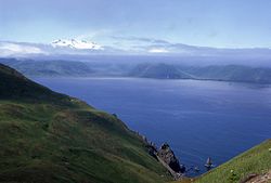
The Makushin Volcano is an ice-covered stratovolcano located on Unalaska Island in the Aleutian Islands of the U.S. state of Alaska. With an elevation of 2,036 meters (6,680 ft), its summit is the highest point on the island. Makushin is one of the most active among the 52 historically active volcanoes of Alaska. It has erupted at least two dozen times over the past several thousand years, with the last eruption occurring in 1995.

Unalaska Airport

Tom Madsen Airport is a state-owned public-use airport in City of Unalaska, on Amaknak Island in the Aleutian Islands, off the coast of the U.S. state of Alaska. It is located near the Bering Sea coast of Unalaska Island, 800 miles (1,300 km) southwest of Anchorage and 1,950 miles (3,140 km) from Seattle.

Dutch Harbor Naval Operating Base and Fort Mears, U.S. Army United States historic place

The Dutch Harbor Naval Operating Base and Fort Mears were the two military installations built next to each other in Dutch Harbor, on Amaknak Island of the Aleutian Islands in Alaska, by the United States in response to the growing war threat with Imperial Japan during World War II. In 1938, the Navy Board recommended the construction which began in July 1940. The first United States Army troops arrived in June 1941 and an air base constructed by the United States Navy was finished in September 1941. At the time of the surprise attack on Pearl Harbor, these were the only military installations in the Aleutian Islands.

Wreck Alley also known as "Sunken Harbor" is an area a few miles off the coast of Mission Beach, San Diego, California with several ships intentionally sunk as artificial reefs and as Scuba diving attractions for wreck divers.

Unalaska Island

Unalaska is a volcanic island in the Fox Islands group of the Aleutian Islands in the US state of Alaska located at 53°38′N167°00′W. The island has a land area of 1,051 square miles (2,720 km2). It measures 79.4 mi (127.8 km) long and 34.7 mi (55.8 km) wide. The city of Unalaska, Alaska, covers part of the island and all of neighboring Amaknak Island where the Port of Dutch Harbor is located. The population of the island excluding Amaknak as of the 2000 census was 1,759 residents.

Aleutian Islands Chain of islands in the northern Pacific Ocean

The Aleutian Islands, also called the Aleut Islands or Aleutic Islands and known before 1867 as the Catherine Archipelago, are a chain of 14 large volcanic islands and 55 smaller islands. Most of the Aleutian Islands belong to the U.S. state of Alaska, but some belong to the Russian federal subject of Kamchatka Krai. They form part of the Aleutian Arc in the Northern Pacific Ocean, occupying an area of 6,821 sq mi (17,666 km2) and extending about 1,200 mi (1,900 km) westward from the Alaska Peninsula toward the Kamchatka Peninsula in Russia, and mark a dividing line between the Bering Sea to the north and the Pacific Ocean to the south. Crossing longitude 180°, at which point east and west longitude end, the archipelago contains both the westernmost part of the United States by longitude and the easternmost by longitude. The westernmost U.S. island in real terms, however, is Attu Island, west of which runs the International Date Line. While nearly all the archipelago is part of Alaska and is usually considered as being in the "Alaskan Bush", at the extreme western end, the small, geologically related Commander Islands belong to Russia.

USCGC Clover WAGL/WLB/WMEC-292, a Cactus (A) Class buoy tender was built by Marine Iron and Shipbuilding, Duluth, Minnesota. Her keel was laid 3 December 1941, and she was launched 25 April 1942. She was commissioned on 8 November 1942 in the United States Coast Guard as the United States Coast Guard Cutter Clover. She was built as a WAGL, redesignated a WLB in 1965, and again redesignated a WMEC in 1979.

Moira Sound is a branching inlet on the east side of the southern end of Prince of Wales Island in U.S. state of Alaska. It is situated within the Tongass National Forest.

Echo Bay (Long Island Sound)

Echo Bay is an embayment located off Long Island Sound in the city of New Rochelle in Westchester County, New York. It is an anchorage for small craft and is generally fully occupied during the summer. The depths at the anchorage range from 4 to 15 feet, and launches can anchor in the shallow cove on the northeast side of the harbor, entering between Harrison Islands and the rocky, grassy islet off the northwest side of Echo Island. Vessels frequently anchor between the entrance of Echo Bay and Hicks Ledge, in depths of 20 to 24 feet. On the northwest side of Echo Bay a dredged channel 100 feet wide and 15 feet deep, marked by buoys, leads to the New Rochelle Municipal Marina at Beaufort Point.

Port Clarence Bay

Port Clarence Bay is a waterway in the U.S. state of Alaska. It has the only harbor and safe anchorage for large vessels in Seward Peninsula. The bay is located 25 miles southeast of York. It is a large body of comparatively deep water, nearly circular in outline, and cut off from the sea by a long, low sand spit, which terminates in Point Spencer at the entrance to the bay. Along the north side of Port Clarence Bay, there is a shallow lagoon, separated from the bay by a narrow sand spit. This lagoon extends several miles west of the entrance to Port Clarence. The hamlet of Port Clarence, Alaska is situated on the bay.

Isanotski Strait

Isanotski Strait is a strait connecting the northern Gulf of Alaska with the Bering Sea, in the U.S. state of Alaska. Isanax̂ is the Aleut name for present day Isanotski Strait, and means gap, hole, rent, or tear in the Aleut language which was rendered as Isanotski in transliterated Russian. The strait appears as Исанакъ in 1802 and Исаноцкый in 1844 on Russian maps.

Ikatan Peninsula

Ikatan Peninsula is the southeastern extremity of Unimak Island in the U.S. state of Alaska.

Fox Islands Passes

The Fox Islands Passes are waterways in the Fox Islands area of the U.S. state of Alaska, connecting the Bering Sea with the North Pacific Ocean.

Cape Kalekhta

Cape Kalekhta is a headland on the northeast coast of Unalaska Island in the U.S. state of Alaska.

Orford Reef

Orford Reef is a reef located off Cape Blanco on the southern coast of Oregon in the United States. The reef is situated around eight small rock islands: Best Rock, Long Brown Rock, Unnamed Rock, Square White Rock, Seal Rock, Conical White Rock, West Conical Rock, and Arch Rock.

MV <i>Eider</i>

MV Eider was an American motor schooner in commission in the fleet of the United States Bureau of Fisheries from 1919 to 1940 and in the fleet of the U.S. Fish and Wildlife Service from 1940 to 1942 and again in the late 1940s. She ran a passenger-cargo service between Unalaska and the Pribilof Islands, and also carried passengers, supplies, and provisions to destinations on the mainland of the Territory of Alaska and in the Aleutian Islands. She occasionally supported research activities in Alaskan waters and the North Pacific Ocean, and she conducted patrols to protect Alaskan fisheries and marine mammals. In 1924, she provided logistical support to the first aerial circumnavigation of the world.

References

  1. Hudson, Ray (2008). Moments Rightly Placed: An Aleutian Memoir. Epicenter Press. pp. 19–. ISBN   978-0-9790470-7-7.
  2. U.S. Coast and Geodetic Survey; Jarvis, D. H. (1900). Alaska: Coast Pilot Notes on the Fox Islands Passes, Unalaska Bay, Bering Sea, and Arctic Ocean as Far as Point Barrow (Public domain ed.). U.S. Government Printing Office. pp.  22–.
  3. U.S. Coast and Geodetic Survey; Graves, Herbert Cornelius (1916). United States Coast Pilot: Alaska. Part II. Yakutat Bay to Arctic Ocean. Part II (Public domain ed.). U.S. Government Printing Office. pp. 210–.