The Fox Islands are a group of islands in the eastern Aleutian Islands of the U.S. state of Alaska. The Fox Islands are the closest to mainland North America in the Aleutian chain, and just east of Samalga Pass and the Islands of Four Mountains group.

The Gulf of Alaska is an arm of the Pacific Ocean defined by the curve of the southern coast of Alaska, stretching from the Alaska Peninsula and Kodiak Island in the west to the Alexander Archipelago in the east, where Glacier Bay and the Inside Passage are found.
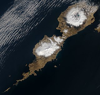
Umnak is one of the Fox Islands of the Aleutian Islands. With 686.01 square miles (1,776.76 km2) of land area, it is the third largest island in the Aleutian archipelago and the 19th largest island in the United States. The island is home to a large volcanic caldera on Mount Okmok and the only field of geysers in Alaska. It is separated from Unalaska Island by Umnak Pass. In 2000, Umnak was permanently inhabited by only 39 people and by 2010, around 18, placing the settlement of Nikolski in difficulty and its school was closed.
Amaknak Island or Umaknak Island is the most populated island in the Aleutian Islands, an archipelago which is part of the U.S. state of Alaska.
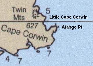
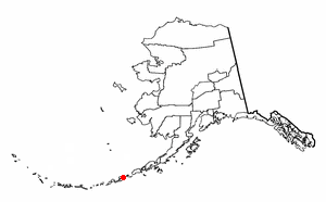
Cape Corwin is the easternmost point of Nunivak Island in the Bering Sea in the U.S. state of Alaska. In the Cup'ig language it is known as Cing'ig. According to Donald Orth the name marks the southwest entrance point to Etolin Strait. According to local usage the feature is misnamed on official United States Geological Survey maps. Since the name was reported to USGS by the USCGS in "about 1908" it may have subsequently migrated to the next northernmost point of land, Cing'ig. The 1911 USCGS chart does not accurately represent the shape of the coast here; the point and the cape are not separately identifiable. The USGS lists Atahgo Point, Valilief Cape, and Chingeleth Point as alternative names for Cape Corwin; Atahgo point also has its own listing with distinct coordinates.
Wislow Island is an island in the Fox Islands group of the eastern Aleutian Islands in the U.S. state of Alaska. It is 520 feet (160 m) across and situated in Reese Bay midway between Capes Wislow and Cheerful on the north coast of Unalaska Island, 11.3 miles (18.2 km) northwest of Dutch Harbor. It was named in 1888 by the U.S. Bureau of Fisheries.
Unalga Island is one of the Fox Islands subgroup of the Aleutian Islands of southwestern Alaska, United States. It lies just northeast of Unalaska Island and across Akutan Pass from Akutan Island to its northeast. It is the westernmost island in the Aleutians East Borough. Unalga Island has a land area of 11.004 square miles and is unpopulated. The island is 6.7 kilometres (4.2 mi) long and 8.2 kilometres (5.1 mi) wide.
Peard Bay is a bay in the Chukchi Sea, in Alaska's North Slope. It is located at 70°50′43″N158°48′39″W. This bay lies just a few miles northeast of Wainwright. It was named by Frederick William Beechey in 1826, after one of his officers.
Mikhail Dmitrievich Levashov was a Russian explorer and Lieutenant of the Imperial Russian Navy. After Vitus Bering's 1741 tragic venture he was, together with Peter Kuzmich Krenitzin, among the first to conduct an expedition to Alaska and the Aleutians.

Unalaska is a volcanic island in the Fox Islands group of the Aleutian Islands in the US state of Alaska located at 53°38′N167°00′W. The island has a land area of 1,051 square miles (2,720 km2). It measures 79.4 mi (127.8 km) long and 34.7 mi (55.8 km) wide. The city of Unalaska, Alaska, covers part of the island and all of neighboring Amaknak Island where the Port of Dutch Harbor is located. The population of the island excluding Amaknak as of the 2000 census was 1,759 residents.

USS Surveyor was an armed steamer that served in the United States Navy from 1917 to 1919. Prior to her U.S. Navy service, she operated as the survey ship USC&GS Surveyor for the United States Coast and Geodetic Survey in 1917, and she returned to that role after her U.S. Navy decommissioning, remaining in Coast and Geodetic Survey service until 1956.

USC&GS Yukon was a schooner that served as a survey ship from 1878 to 1894 in the United States Coast Survey, which was renamed the United States Coast and Geodetic Survey in 1878. She was the pioneering Coast Survey or Coast and Geodetic Survey ship in many of the waters of the Territory of Alaska, including the Bering Sea and the western Aleutian Islands, and she also operated extensively in California and Washington. She later entered commercial service as Elwood and was wrecked in 1895.

The Aleutian Islands —also called the Aleut Islands, Aleutic Islands, or, before 1867, the Catherine Archipelago—are a chain of 14 main, larger volcanic islands and 55 smaller ones. Most of the Aleutian Islands belong to the U.S. state of Alaska, with the archipelago encompassing the Aleutians West Census Area and the Aleutians East Borough. The Commander Islands, located further to the west, belong to the Russian federal subject of Kamchatka Krai, of the Russian Far East. The islands form part of the Aleutian Arc of the Northern Pacific Ocean, and occupy a land area of 6,821 sq mi (17,666 km2) that extends westward roughly 1,200 mi (1,900 km) from the Alaskan Peninsula mainland, in the direction of the Kamchatka Peninsula; the archipelago acts as a border between the Bering Sea to the north and the Pacific Ocean to the south. Crossing longitude 180°, at which point east and west longitude end, the archipelago contains both the westernmost and easternmost parts of the United States, by longitude. The westernmost U.S. island, in real terms, however, is Attu Island, west of which runs the International Date Line. While nearly all of the archipelago is part of Alaska at the extreme western end, the small, geologically-related Commander Islands belong to Russia.

The borders of the oceans are the limits of Earth's oceanic waters. The definition and number of oceans can vary depending on the adopted criteria. The principal divisions of the five oceans are the Pacific Ocean, Atlantic Ocean, Indian Ocean, Southern (Antarctic) Ocean, and Arctic Ocean. Smaller regions of the oceans are called seas, gulfs, bays, straits, and other terms. Geologically, an ocean is an area of oceanic crust covered by water.
David Henry Jarvis was a captain in the United States Revenue Cutter Service. During the harsh winter of 1897–1898, Jarvis, then serving as a first lieutenant aboard the U.S. Revenue Cutter Bear, led the Overland Relief Expedition, bringing a three-man rescue team with a herd of about 400 reindeer across 1,500 miles of tundra and pack-ice to Point Barrow, Alaska, to bring needed food to 265 whalers whose ships had become stranded in the ice off the northern Alaska coast.

Port Clarence Bay is a waterway in the U.S. state of Alaska. It has the only harbor and safe anchorage for large vessels in Seward Peninsula. The bay is located 25 miles southeast of York. It is a large body of comparatively deep water, nearly circular in outline, and cut off from the sea by a long, low sand spit, which terminates in Point Spencer at the entrance to the bay. Along the north side of Port Clarence Bay, there is a shallow lagoon, separated from the bay by a narrow sand spit. This lagoon extends several miles west of the entrance to Port Clarence. The hamlet of Port Clarence, Alaska is situated on the bay.

Isanotski Strait is a strait connecting the northern Gulf of Alaska with the Bering Sea, in the U.S. state of Alaska. Isanax̂ is the Aleut name for present day Isanotski Strait, and means gap, hole, rent, or tear in the Aleut language which was rendered as Isanotski in transliterated Russian. The strait appears as Исанакъ in 1802 and Исаноцкый in 1844 on Russian maps.

Ikatan Peninsula is the southeastern extremity of Unimak Island in the U.S. state of Alaska.

The Fox Islands Passes are waterways in the Fox Islands area of the U.S. state of Alaska, connecting the Bering Sea with the North Pacific Ocean.

Unalaska Bay is a waterway of Unalaska Island in the U.S. state of Alaska. It is situated below the eastern slopes of Makushin Volcano. Composed of seven individual bays, Unalaska Bay opens onto the Bering Sea.


 This article incorporates text from this source, which is in the public domain : U.S. Coast & Geodetic Survey and D. H. Jarvis "Alaska: Coast Pilot Notes on the Fox Islands Passes, Unalaska Bay, Bering Sea, and Arctic Ocean as Far as Point Barrow" (1900)