False Pass is a city on Unimak Island, in the Aleutians East Borough of southwestern Alaska, United States. The population was 35 at the 2010 census, down from 64 in 2000. The 2016 estimate is 42.

St. George is a city in Aleutians West Census Area, Alaska, United States. At the 2010 census the population was 102, down from 152 in 2000. It is the main settlement of St. George Island in the Pribilofs, a small island group in the Bering Sea.

Unimak Island is the largest island in the Aleutian Islands chain of the U.S. state of Alaska.

Adak Island is an island near the western extent of the Andreanof Islands group of the Aleutian Islands in Alaska. Alaska's southernmost town, Adak, is located on the island. The island has a land area of 274.59 square miles (711.18 km2), measuring 33.9 miles (54.5 km) on length and 22 miles (35 km) on width, making it the 25th largest island in the United States.
Amaknak Island or Umaknak Island is the most populated island in the Aleutian Islands.
Sanak Island is an island in the Fox Islands group of the Aleutian Islands in the U.S. state of Alaska. It is located at 54°25′47″N162°42′32″W.
Kanaga Island is a part of the Andreanof Islands group of the Aleutian Islands in Alaska. The island measures 30 miles (48 km) long and between 4–8 miles (6.4–12.9 km) wide with an area of 142 sq mi (368 km2), making it the 42nd largest island in the United States. The island's most notable feature is Mount Kanaga, a 4,288-foot-high (1,307 m) volcano which last erupted in 1995.

Funter Bay is a two-mile-long (3 km) bay on the western side of Admiralty Island near its northern tip, in the Alexander Archipelago of the U.S. state of Alaska. It lies within the Hoonah-Angoon Census Area, in the Unorganized Borough of Alaska.
Amatignak Island is a member of the Delarof Islands, in Alaska's Aleutian archipelago. The southernmost point of Alaska is on this island, as well as the westernmost longitude of Alaska, the United States, and North America.
Round Island is a 0.1-mile-wide (160 m) island in the Krenitzin Islands, a subgroup of the Fox Islands group of the Aleutian Islands in the U.S. state of Alaska. It is located 0.5 miles (800 m) south of Ugamak Island at 54°11′58″N164°46′33″W.
Tigalda Island is one of the Krenitzin Islands, a subgroup of the Fox Islands in the eastern Aleutian Islands, Alaska. Tigalda is located about 19 miles (31 km) east of Akutan Island, is 12 miles (19 km) long and has an area of about 35 square miles (91 km2). Tigalda is an Aleut name published by Captain Lutke (1836). It was called "Kagalga" by Captain Lt. Krenitzin and Lt. Levashev (1768). Tigalda Bay is situated on the north side of Tigalda. Father Veniaminov (1840) reported the existence of an Aleut village, which he called "Tigaldinskoe", of 91 people in 1833. Tigalda is uninhabited.
Ugamak Island is one of the Krenitzin Islands, a subgroup of the Fox Islands group of the eastern Aleutian Islands, Alaska. Ugamak is an Aleut word transcribed by Father Veniaminov (1840) which, according to R. H. Geoghegan, may mean "ceremony island". It is 5.9 miles (9.5 km) long and is located 32 miles (51 km) east of Akutan Island. Ugamak Bay is situated on the southeast coast of Ugamak, and Ugamak Strait is a three-mile-wide channel that separates Ugamak from Kaligagan Island to the west.
Poa Island is an islet located about 0.99 miles (1.59 km) off the south coast of Akun Island in the Fox Islands group of the eastern Aleutian Islands, Alaska. The island is 0.62 miles (1.00 km) long and reaches a maximum elevation of about 200 feet (61 m) above sea level. It was named for a genus of grasses in 1888 by the U.S. Bureau of Fisheries. Captain Tebenkov (1852) called it "Ostrov Tumannyi," meaning "foggy island."
Kagalaska Island is an island in the Andreanof Islands of the Aleutian Islands of Alaska.
Ulak Island is an island in the Delarof Islands subgroup of the Andreanof Islands in the Aleutian Islands chain of Alaska.
Chuginadak Island is the largest island in the Islands of Four Mountains subgroup of the Aleutian archipelago. Chuginadak is an Aleutian name published by Captain Tebenkov in an 1852 map. According to Knut Bergsland's Aleut Dictionary, the Aleutian word "chugida-lix" means "to fry, to make sizzle." The Western half of the island is called Chuginadax in Aleut, meaning 'simmering'.
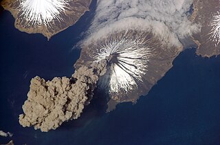
Carlisle Island is an island in the Islands of Four Mountains subgroup of the Aleutian archipelago. It is 1.9 miles (3.1 km) across the Carlisle Pass from Chuginadak Island and is 5.6 miles (9.0 km) northeast of Herbert Island. Carlisle Island has as diameter of 4.3 miles (6.9 km) and is dominated by the 5,280-foot (1,610 m) conical stratovolcano of the same name.
Akutan Island is an island in the Fox Islands group of the eastern Aleutian Islands in the Aleutians East Borough of Alaska.
The Aleutian Islands, also called the Aleut Islands or Aleutic Islands and known before 1867 as the Catherine Archipelago, are a chain of 14 large volcanic islands and 55 smaller ones belonging to both the U.S. state of Alaska and the Russian federal subject of Kamchatka Krai. They form part of the Aleutian Arc in the Northern Pacific Ocean, occupying an area of 6,821 sq mi (17,666 km2) and extending about 1,200 mi (1,900 km) westward from the Alaska Peninsula toward the Kamchatka Peninsula in Russia, and mark a dividing line between the Bering Sea to the north and the Pacific Ocean to the south. Crossing longitude 180°, at which point east and west longitude end, the archipelago contains both the westernmost part of the United States by longitude and the easternmost by longitude. The westernmost U.S. island in real terms, however, is Attu Island, west of which runs the International Date Line. While nearly all the archipelago is part of Alaska and is usually considered as being in the "Alaskan Bush", at the extreme western end, the small, geologically related Commander Islands belong to Russia.