
Adak, formerly Adak Station, is a city located on Adak Island, in the Aleutians West Census Area, Alaska, United States. At the 2010 census the population was 326, up from 316 in 2000. It is the westernmost municipality in the United States and the southernmost city in Alaska. The city is the former location of the Adak Army Base and Adak Naval Operating Base, NAVFAC Adak. There are no radio stations within 200 miles (320 km) of Adak; radio can be received in Adak only through satellite or shortwave receivers.

St. George is a city in Aleutians West Census Area, Alaska, United States. At the 2010 census the population was 102, down from 152 in 2000. It is the main settlement of St. George Island in the Pribilofs, a small island group in the Bering Sea.

The Andreanof Islands are a group of islands in the Aleutian Islands, in southwestern Alaska. They are located at about 52° North and 172°57' to 179°09' West.

Kanaga Island is a part of the Andreanof Islands group of the Aleutian Islands in Alaska. The island measures 30 miles (48 km) long and between 4–8 miles (6.4–12.9 km) wide with an area of 142 sq mi (368 km2), making it the 42nd largest island in the United States. The island's most notable feature is Mount Kanaga, a 4,288-foot-high (1,307 m) volcano which last erupted in 1995.
Amatignak Island is a member of the Delarof Islands, in Alaska's Aleutian archipelago. The southernmost point of Alaska is on this island, as well as the westernmost longitude of Alaska, the United States, and North America.
Ugamak Island is one of the Krenitzin Islands, a subgroup of the Fox Islands group of the eastern Aleutian Islands, Alaska. Ugamak is an Aleut word transcribed by Father Veniaminov (1840) which, according to R. H. Geoghegan, may mean "ceremony island". It is 5.9 miles (9.5 km) long and is located 32 miles (51 km) east of Akutan Island. Ugamak Bay is situated on the southeast coast of Ugamak, and Ugamak Strait is a three-mile-wide channel that separates Ugamak from Kaligagan Island to the west.
Gareloi or Anangusook is a volcanic island in the Delarof Islands of the Aleutian Islands of Alaska. It is located between the Tanaga Pass and the Amchitka Pass.
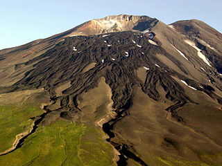
Great Sitkin Island is a volcanic island in the Andreanof Islands of the Aleutian Islands of Alaska. The island covers a total area of 60 square miles (160 km2) and lies slightly north of a group of islands which are located between Adak Island and Atka Island.
Igitkin Island is a small island located in an area between Adak Island and Atka Island among other small islands. The island belongs to the Andreanof Islands of the Aleutian Islands of Alaska.
Kagalaska Island is an island in the Andreanof Islands of the Aleutian Islands of Alaska.
Little Tanaga Island is an island located in the Andreanof Islands of the Aleutian Islands of Alaska. It lies between Kagalaska Island and Umak Island. The island is 12.5 kilometres (7.8 mi) long and 16.3 kilometres (10.1 mi) wide.
Tagalak Island is an island located in the central area of the Andreanof Islands of the Aleutian Islands of Alaska. West of the island lies Chugul. The island is 6.3 kilometres (3.9 mi) long and 7 kilometres (4.3 mi) wide.
Ulak Island is an island in the Delarof Islands subgroup of the Andreanof Islands in the Aleutian Islands chain of Alaska.
Yunaska is the largest of the Islands of Four Mountains group in the Aleutian Islands of southwestern Alaska, United States. It has a land area of 66.834 square miles and no population at the 2000 census.
Unalga Island is one of the Fox Islands subgroup of the Aleutian Islands of southwestern Alaska, United States. It lies just northeast of Unalaska Island and across Akutan Pass from Akutan Island to its northeast. It is the westernmost island in the Aleutians East Borough. Unalga Island has a land area of 11.004 square miles and is unpopulated. The island is 6.7 kilometres (4.2 mi) long and 8.2 kilometres (5.1 mi) wide.
Egg Island is a small island in the Fox Islands subgroup of the Aleutian Islands in the U.S. state of Alaska. It lies off the eastern end of Unalaska Island and just off the northeastern tip of Sedanka Island. It is the easternmost island in the Aleutians West Census Area of Alaska. The island has a land area of 311.12 acres (1.259 km²) and is uninhabited. It is 19.3 kilometres (12.0 mi) long and 12 kilometres (7.5 mi) wide.

Tanaga Island is an island in the western Andreanof Islands, in the southwest part of the Aleutian Islands, Alaska. The island has a land area of 204 square miles, making it the 33rd largest oceanic island in the United States. Its highest point is volcano Mount Tanaga at 5,925 feet.

Unalaska is an island in the Fox Islands group of the Aleutian Islands in the US state of Alaska located at 53°38′N167°00′W. The island has a land area of 1,051 square miles (2,720 km2). It measures 79.4 mi (127.8 km) long and 34.7 mi (55.8 km) wide. The city of Unalaska, Alaska, covers part of the island and all of neighboring Amaknak Island where the Port of Dutch Harbor is located. The population of the island excluding Amaknak as of the 2000 census was 1,759 residents.
Aziak Island is a small island in the Andreanof Islands group in the Aleutian Islands of southwestern Alaska. The name "Aziak" is derived from the Aleut word ha-azax - "ten," and in many books and charts published before 1920, it was often used to refer to Sledge Island, located 930 miles (1,500 km) to the northeast off the Seward Peninsula, or to a native settlement on that island. This practice apparently became rarer as the twentieth century progressed and today Aziak is used almost exclusively to refer the Andreanof-group island. Aziak Island is approximately 1.1 miles (1.8 km) long and reaches a maximum elevation of 190 feet (58 m). Very little is known about the island and it is uninhabited.


