Related Research Articles

The tufted puffin, also known as crested puffin, is a relatively abundant medium-sized pelagic seabird in the auk family (Alcidae) found throughout the North Pacific Ocean. It is one of three species of puffin that make up the genus Fratercula and is easily recognizable by its thick red bill and yellow tufts.

Puffins are any of three species of small alcids (auks) in the bird genus Fratercula. These are pelagic seabirds that feed primarily by diving in the water. They breed in large colonies on coastal cliffs or offshore islands, nesting in crevices among rocks or in burrows in the soil. Two species, the tufted puffin and horned puffin, are found in the North Pacific Ocean, while the Atlantic puffin is found in the North Atlantic Ocean.

The Bering Sea is a marginal sea of the Northern Pacific Ocean. It forms, along with the Bering Strait, the divide between the two largest landmasses on Earth: Eurasia and The Americas. It comprises a deep water basin, which then rises through a narrow slope into the shallower water above the continental shelves. The Bering Sea is named for Vitus Bering, a Danish navigator in Russian service, who, in 1728, was the first European to systematically explore it, sailing from the Pacific Ocean northward to the Arctic Ocean.
Bering Island is located off the Kamchatka Peninsula in the Bering Sea.
The Kuril Islands or Kurile Islands are a volcanic archipelago currently administered as part of Sakhalin Oblast in the Russian Far East. It stretches approximately 1,300 km (810 mi) northeast from Hokkaido in Japan to Kamchatka Peninsula in Russia separating the Sea of Okhotsk from the north Pacific Ocean. There are 56 islands and many minor rocks. The Kuril Islands consist of the Greater Kuril Chain and the Lesser Kuril Chain. They cover an area of around 10,503.2 square kilometres (4,055.3 sq mi), with a population of roughly 20,000.

The Kamchatka Peninsula is a 1,250-kilometre-long (777 mi) peninsula in the Russian Far East, with an area of about 270,000 km2 (104,248 sq mi). The Pacific Ocean and the Sea of Okhotsk make up the peninsula's eastern and western coastlines, respectively. Immediately offshore along the Pacific coast of the peninsula runs the 10,500-metre-deep (34,449 ft) Kuril–Kamchatka Trench.

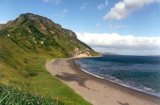
The Commander Islands, Komandorski Islands, or Komandorskie Islands are a series of treeless, sparsely populated Russian islands in the Bering Sea located about 175 km (109 mi) east of the Kamchatka Peninsula in the Russian Far East. The islands consist of Bering Island, Medny Island and fifteen smaller ones, the largest of which are Tufted Puffin Rock , 15 ha, and Kamen Ariy, which are between 3 km (1.9 mi) and 13 km (8.1 mi) west of the only settlement, Nikolskoye. Administratively, they compose Aleutsky District of Kamchatka Krai in Russia.
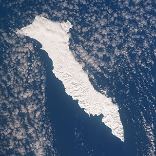
Medny Island, also spelled Mednyy or Mednyi, sometimes called Copper Island in English, is the smaller of the two main islands in the Commander Islands in the North Pacific Ocean, east of Kamchatka, Russia. These islands belong to the Kamchatka Krai of the Russian Federation.

Sea Lion Rock, is a rock islet just off Medny Island in the Commander Islands archipelago, in the Bering Sea.
Sea Otter Rocks are rock islets of the Commander Islands archipelago in the Bering Sea, Russia.

The Shantar Islands are a group of fifteen islands located off the northwestern shore of the Sea of Okhotsk east of Uda Gulf and north of Academy Bay. Most of the islands have rugged cliffs, but they are of moderate height; the highest point in the island group is 720 metres. The name of the island group has its origins in the Nivkh language from the word ч’андь č’and’ meaning "to be white". The islands are currently uninhabited.

Iony Island, or Jonas' Island, formerly Ostrov Svyatogo Iony, is a small island in the Sea of Okhotsk.

Tyuleny Island is a small island in the Sea of Okhotsk, east of Russia's Sakhalin Island, in Northeast Asia. It is also called Kaihyo Island (海豹島).
Kamchatka Strait is a 191 km-wide strait off the mainland coast of Kamchatka Krai in the Russian Far East.

The Aleutian Islands, also called the Aleut Islands or Aleutic Islands and known before 1867 as the Catherine Archipelago, are a chain of 14 large volcanic islands and 55 smaller islands. Most of the Aleutian Islands belong to the U.S. state of Alaska, but some belong to the Russian federal subject of Kamchatka Krai. They form part of the Aleutian Arc in the Northern Pacific Ocean, occupying a land area of 6,821 sq mi (17,666 km2) and extending about 1,200 mi (1,900 km) westward from the Alaska Peninsula toward the Kamchatka Peninsula in Russia, and act as a border between the Bering Sea to the north and the Pacific Ocean to the south. Crossing longitude 180°, at which point east and west longitude end, the archipelago contains both the westernmost part of the United States by longitude and the easternmost by longitude. The westernmost U.S. island in real terms, however, is Attu Island, west of which runs the International Date Line. While nearly all the archipelago is part of Alaska and is usually considered as being in the "Alaskan Bush", at the extreme western end, the small, geologically related Commander Islands belong to Russia.

Aleutsky District is an administrative and municipal district (raion) of Kamchatka Krai, Russia, one of the eleven in the krai. It is located to the east of the Kamchatka Peninsula on the Commander Islands. The area of the district is 1,580 square kilometers (610 sq mi). The islands consist of Bering Island, Medny Island and fifteen much smaller ones, the largest of which are Tufted Puffin Rock, 15 hectares, and Kamen Ariy, which are between 3 km and 13 km west of the only settlement, Nikolskoye. Its administrative center is the rural locality of Nikolskoye. Population: 676 (2010 Census); 808 (2002 Census); 1,356 (1989 Census). All of the district's population resides in Nikolskoye.
The wildlife of Russia inhabits terrain that extends across 12 time zones and from the tundra region in the far north to the Caucasus Mountains and prairies in the south, including temperate forests which cover 70% of the country's territory. Russia's forests comprise 22% of the forest in the world as well as 33% of all temperate forest in the world.
The Scott Islands are a group of islands located off the northwestern point of Vancouver Island, British Columbia.

Kamen Ariy, or Ary Rock is a small islet of the Commander Islands in the North Pacific Ocean, east of the Kamchatka Peninsula in Eastern Russia. These islands belong to the Kamchatka Krai of the Russian Federation. Kamen Ariy is about 8 km (5 mi) west of Tufted Puffin Rock and consists of two rocks. The northern rock is pointed and reaches a height of 45 m (150 ft). The southern rock is much flatter and only reaches a height of 2.1 m.
References
- 1 2 Sailing Directions (enroute) East Coast of Russia. Defense Mapping Agency, Hydrographic/Topographic Center. 1995.