
Lesotho is a mountainous, landlocked country located in Southern Africa. It is an enclave, surrounded by South Africa. The total length of the country's borders is 909 kilometres (565 mi). Lesotho covers an area of around 30,355 square kilometres (11,720 sq mi), of which a negligible percentage is covered with water.

Maseru is the capital and largest city of Lesotho. It is also the capital of the Maseru District. Located on the Caledon River, Maseru lies directly on the Lesotho–South Africa border. Maseru had a population of 330,760 in the 2016 census. The city was established as a police camp and assigned as the capital after the country became a British protectorate in 1869. When the country achieved independence in 1966, Maseru retained its status as capital. The name of the city is a Sesotho word meaning "red sandstones".

The Kingdom of Lesotho is divided into ten districts, each headed by a district administrator. Each district has a capital known as a camptown. The districts are further subdivided into 80 constituencies, which consist of 129 local community councils. Most of the districts are named after their capitals. Hlotse, the capital of Leribe District is also known as Leribe. Conversely, the Berea District is sometimes called Teyateyaneng, based on its capital.
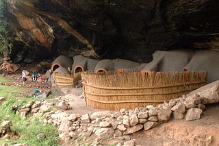
Berea is a district of Lesotho. In the west, Berea borders on the Free State Province of South Africa. Domestically, it borders on the following districts: Leribe District in the north, Thaba-Tseka District in southeast and Maseru District in the south. Teyateyaneng is the capital of the district. It is also home to the Kome Cave Dwellings. It is also the only district in Lesotho which is not named after its capital.

Maseru is a district of Lesotho. Maseru is also the name of the district's capital, and is the only city in the district and also the capital of the country. It is the largest urban area in the country, and therefore the only city. The city of Maseru is located on Lesotho's western border with the Free State Province of South Africa, the frontier being the Caledon River. Maseru borders on Berea District in north, Thaba-Tseka District in the east, Mohale's Hoek District in south, and Mafeteng District in southwest.

Mokhotlong is a city and seat of Mokhotlong District in the mountainous northeastern part of Lesotho. It is the first major city with an airport along the road from South Africa across the Sani Pass, near the Maloti Mountains. The name of the city is a word in Sesotho, the language of the people of Lesotho, meaning "Place of the Bald Ibis." Thabana Ntlenyana, the highest point in southern Africa, is found in Mokhotlong.

Qacha's Nek is, since 1888, the camptown (capital) of Qacha's Nek District in Lesotho, only two kilometers from the South African border at 1,980 meters (6,500 ft) above sea level. It has a population of approximately 15,900 (2016). It is home to Machabeng Government Hospital, one of the two hospitals in the district.

View Royal is a town in Greater Victoria and a member municipality of the Capital Regional District of British Columbia, Canada. View Royal has a population of 10,858 residents. With over 700 hectares of parkland, View Royal includes McKenzie, Pike, Prior and Thetis Lakes and portions of the Esquimalt Harbour and Portage Inlet.

The Caledon River is a major river located in central South Africa. Its total length is 642 km (399 mi), rising in the Drakensberg Mountains on the Lesotho border, flowing southwestward and then westward before joining the Orange River near Bethulie in the southern Free State.

Teyateyaneng is a town located in the district of Berea in Lesotho. Usually abbreviated to T.Y., Teyateyaneng takes its name from the two twin rivers which run on the north and the South. Both rivers lead to the Mohokare, or the Caledon River which forms the western boundary with South Africa. They are both named for their vast quantities of sand which means rapid dipping of feet as one crosses them, leading to both names which may well suggest that this is a 'place of quick sands'. Teyateyaneng's name therefore comes from the southern Teja-tejana River, but the name later changed to Teyateyaneng, perhaps due to British influences as the country became a Protectorate in the late 1800s.
A camptown, in the country of Lesotho, refers to a district capital for one of the ten districts of Lesotho. The largest camptown is the city of Maseru in Maseru District. Camptowns are usually commerce hubs for the district and are the location for the central government offices for the district. Camptowns usually take the same name as the district in which they are located. For example, as mentioned the camptown for Maseru is Maseru but also the camptown for Thaba-Tseka District is Thaba-Tseka. The exceptions to this rule are Berea District whose capital is called Teyateyaneng, Quthing District whose capital is called Moyeni and Leribe District whose capital is most often called Hlotse.
Morija Museum & Archives, also known as Morija Museum, is located in Morija, a large village in the Maseru district of Lesotho. The museum was formally opened in 1956, and entered its present permanent facilities in 1989. The purpose of the museum is to carry on the tradition of Morija, as a centre of learning, innovation and excellence, in Lesotho. Morija Museum is home to many cultural treasures including, traditional Basotho artifacts as well as Lifaqane and Boer War memorabilia. The archives portion of the museum includes documents dated as far back as 1826. This collection is extremely rich in 19th century documentation related to Lesotho.
Mazenod is a community council located in the Maseru District of western Lesotho. The population in 2006 was 27,553. It is located to the south-east of the capital Maseru. Points of interest include Moshoeshoe I International Airport, Lesotho's only international airport.

The following outline is provided as an overview of and topical guide to Lesotho:
Kanana is a community council located in the Berea District of Lesotho. Its population in 2006 was 19,311.
Motanasela is a community council located in the Berea District of Lesotho. Its population in 2006 was 19,817.
Qiloane is a community council located in the Maseru District of Lesotho. Its population in 2006 was 24,093.
Mabote is a constituency and community council in the Maseru Municipality located in the Berea District of Lesotho. The population in 2006 was 38,047.
Lithabaneng is a constituency and community council in the Maseru Municipality located in the Maseru District of Lesotho. The population in 2006 was 28,371.
The Lesotho Sky is a 6-day mountain bike stage race that takes place in the Kingdom of Lesotho. The event has been sanctioned by the Lesotho Cycling Association since 2011. It has been accredited as category 1 by the Union Cycliste Internationale. The event first took place in 2011 covering 430 km over the 6 days. More recently the route has shortened to 340 km with a time trial through the capital of Maseru to start. The Lesotho Sky is a small event but attracts professional and amateur riders from around the world. Riders are required to ride in teams of 2 that must stay within 2 minutes of each other throughout the event. The times taken for each team to finish each day are added together and the shortest total time is the winner.


