Teyateyaneng

Last updated
Teyateyaneng
'Malifate
CountryFlag of Lesotho.svg  Lesotho
District Berea District
Founded byChief Masupha
Elevation
1,693 m (5,554 ft)
Location of Teyateyaneng in Lesotho LS-Teyateyaneng.png
Location of Teyateyaneng in Lesotho

Teyateyaneng is a town located in the district of Berea in Lesotho. Usually abbreviated to T.Y., Teyateyaneng takes its name from the two twin rivers which run on the north (Tebe-tebe River) and the South (Teja-tejana River). Both rivers lead to the Mohokare, or the Caledon River which forms the western boundary with South Africa. They are both named for their vast quantities of sand which means rapid dipping of feet as one crosses them, leading to both names which may well suggest that this is a 'place of quick sands'. Teyateyaneng's name therefore comes from the southern Teja-tejana River, but the name later changed to Teyateyaneng, perhaps due to British influences as the country became a Protectorate in the late 1800s.

Contents

The town is situated approximately 400 km south of Johannesburg, 184 km east of Bloemfontein, and 517 km west of Durban, all major metros in the neighbouring South Africa. [1] Teyateyaneng is also the camptown for the district of Berea. In 2005 it had a population of 75,115.

Geography

Lioli Gateway.JPG

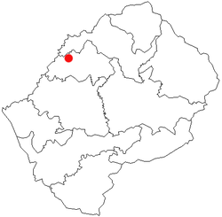
Teyateyaneng is located about 40 kilometers north east of the national capital of Maseru on the Main North I highway, a road that runs parallel to the South African border leading to the northern town of Butha-Buthe. The town is situated on a high plateau at 1,693 meters altitude.

Climate

Climate data for Teyateyaneng (1981–2010)
MonthJanFebMarAprMayJunJulAugSepOctNovDecYear
Mean daily maximum °C (°F)27.5
(81.5)
27.0
(80.6)
25.5
(77.9)
22.8
(73.0)
19.7
(67.5)
17.0
(62.6)
16.9
(62.4)
19.4
(66.9)
23.1
(73.6)
24.9
(76.8)
26.1
(79.0)
27.2
(81.0)
23.1
(73.6)
Mean daily minimum °C (°F)14.8
(58.6)
14.6
(58.3)
12.7
(54.9)
8.8
(47.8)
4.5
(40.1)
1.2
(34.2)
0.4
(32.7)
3.5
(38.3)
7.4
(45.3)
10.8
(51.4)
12.7
(54.9)
14.1
(57.4)
8.8
(47.8)
Average rainfall mm (inches)118.9
(4.68)
91.3
(3.59)
102.8
(4.05)
46.1
(1.81)
18.3
(0.72)
12.6
(0.50)
1.9
(0.07)
17.2
(0.68)
18.6
(0.73)
71.3
(2.81)
69.1
(2.72)
90.9
(3.58)
659
(25.94)
Average rainy days (≥ 0.5 mm)1291063212388973
Source: World Meteorological Organization [2]

History

Teyateyaneng was founded in 1886 as the capital of Berea by then Chief Gabasheane Masupha, one of the sons of the nation's founder King Moshoeshoe I. The town is the birthplace of many famous Basotho including the late former Prime Minister Dr. Ntsu Mokhehle, renowned musicians Tshepo Tshola and Sechaba 'Fatere' Litabe, and more recently; accomplished broadcasters such as J-Tagg Tsiame.

Economy

Teyateyaneng has several retail businesses and carpet-producing and tapestry factories, though with little industrial activity overall, perhaps owing to its close proximity to the larger Maseru. The town has remained the country's athletic, art and entertainment capital with many events being hosted here regularly.

Sports

Football

Lioli player Lioli skill.jpg
Lioli player

The Lioli Football Club is one of the country's best-known football clubs. The club was founded and is based in Teyateyaneng since 1934. In 1985 the team won the Lesotho Premier League for the first time, but the club's most successful era was in the 2010s when it won league championships in 2009, 2013, 2015, and 2016. The club also won the Lesotho Independence Cup in 1984, 2007, 2010, 2014, and 2016, as well at the MGC Supa 8 Cup numerous other times in the modern era. The team also came second in the league twice in a row in the 2016–17, and 2017–18 seasons.

Unlike many other growing western lowlands towns that have seen an emergence of privately owned clubs over the years, the people of Teyateyaneng have rallied behind the club through the years, taking pride in the iconic identity of the club whose name is synonymous with the town's founding Chief Masupha's regiment "Lioli", named after the red hawk. The club arguably boasts the largest active fan base in Lesotho's premier league today.

Cricket

The town has proven to be an athletic powerhouse of Lesotho over the years, producing prolific footballers who have represented Lesotho internationally at different levels. In the late 1990s as the country revived the cricket sports, Teyateyaneng further produced many players who rose through high school competitions to represent the country since. Earlier players included the likes of all-rounders Ts'epo 'Muso, Seisa Tsiame, and Ts'epo Lephema among others, before another generation of players such as Leokaoke Lebona, batsman Thabang Mafereka, and pace bowlers Ian Osler and Thabiso Mohapi emerged.

Other sporting disciplines are played at a school level, but football and cricket remain the town's largest sporting quotes.

Points of interest

Teyateyaneng as a district capital has multiple schools, a district referral hospital and several recreational and tourism facilities such as hotels, lodges and cafes. The town is also surrounded by several rock caves with cave paintings of the Khoi San tribes that once occupied the place centuries ago before the Basotho people migrated south to settle in the Mohokare River valley, before ultimately becoming an organized state with inhabitants going further to occupy the mountainous terrain to the east and the south of what is the present day Lesotho.

The Kome Cave Dwellings were built and protected by Chief Teleka of The Basia (cat) Clan in the early 19th century. The town's friendly close-knit community is always willing to accompany tourists on many hiking trails at request. The town is much closer to the country's eastern highlands compared to many of its lowlands neighbours and offers interesting mountain side settlements and cattle posts hiking trails in the east.

Related Research Articles

<span class="mw-page-title-main">Lesotho</span> Country in Southern Africa

Lesotho, formally the Kingdom of Lesotho, is a landlocked country in Southern Africa. As an enclave of South Africa, with which it shares a 1,106 km (687 mi) border, it is the largest sovereign enclave in the world, and the only one outside of the Italian Peninsula. It is situated in the Maloti Mountains and contains the highest peak in Southern Africa. It has an area of over 30,000 km2 (11,600 sq mi) and has a population of about two million. Its capital and largest city is Maseru. The country is also known by the nickname The Mountain Kingdom.

This article concerns systems of transport in Lesotho. As a landlocked country, Lesotho has no seaports or harbours, but does have road, air transport, and limited rail infrastructure.

<span class="mw-page-title-main">Maseru</span> Capital and largest city of Lesotho

Maseru is the capital and largest city of Lesotho. It is also the capital of the Maseru District. Located on the Caledon River, Maseru lies directly on the Lesotho–South Africa border. Maseru had a population of 330,760 in the 2016 census. The city was established as a police camp and assigned as the capital after the country became a British protectorate in 1869. When the country achieved independence in 1966, Maseru retained its status as capital. The name of the city is a Sesotho word meaning "red sandstones".

<span class="mw-page-title-main">Basutoland</span> British colony from 1884 to 1966

Basutoland was a British Crown colony that existed from 1884 to 1966 in present-day Lesotho, bordered with the Cape Colony, Natal Colony and Orange River Colony until 1910 and completely surrounded by South Africa from 1910. Though the Basotho and their territory had been under British control starting in 1868, the Cape Colony was unpopular and unable to control the territory. As a result, Basutoland was brought under direct authority of Queen Victoria, via the High Commissioner, and run by an Executive Council presided over by a series of British Resident Commissioners.

<span class="mw-page-title-main">Sotho people</span> Bantu ethnic group of Southern Africa

The Sotho, also known as the Basotho, are a Sotho-Tswana ethnic group native to Southern Africa. They primarily inhabit the regions of Lesotho and South Africa.

<span class="mw-page-title-main">Berea District</span> District in Lesotho

Berea is a district of Lesotho. In the west, Berea borders on the Free State Province of South Africa. Domestically, it borders on the following districts: Leribe District in the north, Thaba-Tseka District in southeast and Maseru District in the south. Teyateyaneng is the capital of the district. It is also home to the Kome Cave Dwellings. It is also the only district in Lesotho which is not named after its capital.

<span class="mw-page-title-main">Maseru District</span> District of Lesotho

Maseru is a district of Lesotho. Maseru is also the name of the district's capital, and is the only city in the district and also the capital of the country. It is the largest urban area in the country, and therefore the only city. The city of Maseru is located on Lesotho's western border with the Free State Province of South Africa, the frontier being the Caledon River. Maseru borders on Berea District in north, Thaba-Tseka District in the east, Mohale's Hoek District in south, and Mafeteng District in southwest.

<span class="mw-page-title-main">Mohale's Hoek</span>

Mohale's Hoek is the capital city of Mohale's Hoek District in Lesotho. It had a population of approximately 40,040 in 2016.

<span class="mw-page-title-main">Smithfield, South Africa</span> Place in Free State, South Africa

Smithfield is a small town in the Free State province of South Africa. Founded in 1848 in the Orange River Sovereignty, the town is situated in a rural farming district and is the third oldest town in present-day Free State, after Philippolis and Winburg.

<span class="mw-page-title-main">Caledon River</span> Major river in Lesotho and South Africa

The Caledon River is a major river located in central South Africa. Its total length is 642 km (399 mi), rising in the Drakensberg Mountains on the Lesotho border, flowing southwestward and then westward before joining the Orange River near Bethulie in the southern Free State. The river was originally named Prinses Wilhelminas Rivier in 1777, by Colonel R J Gordon.

<span class="mw-page-title-main">Lesotho Premier League</span> Football league

The Lesotho Premier League, also known as Vodacom Premier League for sponsorship reasons, is the top football division in Lesotho and was created in 1970. Econet Telecom Lesotho was the league sponsor, from 2017/2018 to 2019/2020 season. Vodacom Lesotho are again the current league sponsor and were also the sponsor of the now cancelled Vodacom Soccer Spectacular knockout competition, which was the Lesotho's annual national cup tournament.

<span class="mw-page-title-main">N8 (South Africa)</span> National road in South Africa

The N8 is a national route in South Africa that connects Groblershoop with Maseru in Lesotho via Kimberley and Bloemfontein. It is maintained by the South African National Roads Agency.

<span class="mw-page-title-main">Thaba Bosiu</span> Constituency and sandstone plateau in Maseru District, Lesotho

Thaba Bosiu is a constituency and sandstone plateau with an area of approximately 2 km2 (0.77 sq mi) and a height of 1,804 meters above sea level. It is located between the Orange and Caledon Rivers in the Maseru District of Lesotho, 24 km east of the country's capital Maseru. It was once the capital of Lesotho, having been King Moshoeshoe's stronghold.

<span class="mw-page-title-main">Lioli FC</span> Lesotho football club

Lioli Football Club is an association football club in the Lesotho Premier League. The team is based in Teyateyaneng. The club has won six league championships, in 1985, 2009, 2013, 2015, 2016 and 2024. The team's kit is manufactured by Umbro SA.

The sport of football in the country of Lesotho is run by the Lesotho Football Association. The association administers the national football team, as well as the Premier League. Football is the most popular sport in the country.

<span class="mw-page-title-main">Kome Caves</span> Settlement and heritage site in Berea, Lesotho

The Kome Caves are a group of cave dwellings made out of mud in the district of Berea, Lesotho 25 km east of Teyateyaneng. The caves are still inhabited by the descendants of the original people who built the caves. The site has been classified as a National Heritage Site.

<span class="mw-page-title-main">History of rail transport in Lesotho</span>

The history of rail transport in Lesotho began in 1905, when the landlocked nation of Lesotho was connected with the railway network of South Africa. The two nations have remained connected by a single railway line ever since.

<span class="mw-page-title-main">2014 Lesotho political crisis</span> Political crisis

On 30 August 2014, Lesotho's Prime Minister Tom Thabane alleged that a coup d'état had been launched against him. This followed a previous allegation which caused him to suspend parliament over possible extra-constitutional manoeuvres. It also followed pressure from South Africa to maintain the democratic process. The next day, Deputy Prime Minister Mothetjoa Metsing assumed responsibility for running the government. An early election was held in February 2015 as a result of South African-led Southern African Development Community (SADC) mediation, giving power to the opposition.

Lehlohonolo Moses Maliehe is a South African former professional soccer player who was most recently manager of Lesotho.

<span class="mw-page-title-main">'Mantsopa</span> Basotho prophet (1793–1908)

'Mantsopa Anna Makhetha (1793–1908), often referred to as 'Mantsopa, was a Basotho prophetess, rainmaker, and storyteller. She advised King Moshoeshoe I and predicted the outcomes of several battles, including the Battle of Viervoet in 1851 and the Battle of Berea in 1852. She was exiled to Modderpoort in the late 1860s, where she converted to Christianity and was baptised in 1870. She fused Christianity with her own traditional Basotho customs.

References

  1. Lesotho Embassy in Rome Archived 2011-07-13 at the Wayback Machine
  2. "World Weather Information Service". World Meteorological Organization. Retrieved 18 August 2024.

29°09′04″S27°44′33″E / 29.15111°S 27.74250°E / -29.15111; 27.74250