
Lesotho, formally the Kingdom of Lesotho, is a landlocked country in Southern Africa. As an enclave of South Africa, with which it shares a 1,106 km (687 mi) border, it is the largest sovereign enclave in the world, and the only one outside of the Italian Peninsula. It is situated in the Maloti Mountains and contains the highest peak in Southern Africa. It has an area of over 30,000 km2 (11,600 sq mi) and has a population of about two million. Its capital and largest city is Maseru. The country is also known by the nickname The Mountain Kingdom.

Lesotho is a mountainous, landlocked country located in Southern Africa. It is an enclave, surrounded by South Africa. The total length of the country's borders is 909 kilometres (565 mi). Lesotho covers an area of around 30,355 square kilometres (11,720 sq mi), of which a negligible percentage is covered with water.

Politics of Lesotho takes place in a framework of a parliamentary representative democratic constitutional monarchy, whereby the Prime Minister of Lesotho is the head of government, and of a multi-party system. Executive power is exercised by the government. Legislative power is vested in both the government and the two chambers of Parliament, the Senate and the National Assembly. The Judiciary is independent of the executive and the legislature.

The Sotho, also known as the Basotho, are a Sotho-Tswana ethnic group native to Southern Africa. They primarily inhabit the regions of Lesotho and South Africa.

Moshoeshoe I was the first king of Lesotho. He was the first son of Mokhachane, a minor chief of the Bamokoteli lineage, a branch of the Koena (crocodile) clan. In his youth, he helped his father gain power over some other smaller clans. At the age of 34 Moshoeshoe formed his own clan and became a chief. He and his followers settled at the Butha-Buthe Mountain. He became the first and longest-serving King of Lesotho in 1822.

The Free State, formerly known as the Orange Free State, is a province of South Africa. Its capital is Bloemfontein, which is also South Africa's judicial capital. Its historical origins lie in the Boer republic called the Orange Free State and later the Orange Free State Province.

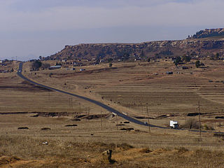
Butha-Buthe is a district of Lesotho. Butha-Buthe is the capital or camptown, and only town in the district. In the north, Butha-Buthe borders on the Free State Province of South Africa. Domestically, it borders on Mokhotlong District in southeast and Leribe District on the south.

Mokhotlong district is a district of Lesotho. It includes the highest terrain in the Maloti Mountains and the source of the Senqu River, Lesotho's primary watershed. Mokhotlong is the capital or camptown, and only town in the district. Mokhotlong borders on the KwaZulu-Natal Province of South Africa, with its north point bordering the Free State Province. Domestically, it borders on Butha-Buthe District in northwest, Leribe District in west, and Thaba-Tseka District in the south.
Leribè is a district of Lesotho. It has an area of 2,828 km2 and a population in 2016 of approximately 337,500. Hlotse is the capital or camptown of the district. The district has one additional town, namely Maputsoe. In the west, Leribe borders on the Free State Province of South Africa. Domestically, it borders Butha-Buthe District in the north, Mokhotlong District in the east, Thaba-Tseka District in southeast and Berea District in southwest.

Mohale's Hoek is the capital city of Mohale's Hoek District in Lesotho. It had a population of approximately 40,040 in 2016.
Mokhotlong is a constituency, city and seat of Mokhotlong District in the mountainous northeastern part of Lesotho. It is the first major city with an airport along the road from South Africa across the Sani Pass, near the Maloti Mountains. The name of the city is a word in Sesotho, the language of the people of Lesotho, meaning "Place of the Bald Ibis." Thabana Ntlenyana, the highest point in southern Africa, is found in Mokhotlong.

Teyateyaneng is a town located in the district of Berea in Lesotho. Usually abbreviated to T.Y., Teyateyaneng takes its name from the two twin rivers which run on the north and the South. Both rivers lead to the Mohokare, or the Caledon River which forms the western boundary with South Africa. They are both named for their vast quantities of sand which means rapid dipping of feet as one crosses them, leading to both names which may well suggest that this is a 'place of quick sands'. Teyateyaneng's name therefore comes from the southern Teja-tejana River, but the name later changed to Teyateyaneng, perhaps due to British influences as the country became a Protectorate in the late 1800s.

Rockcliffe Park Public School (RPPS) is a public elementary school in the Rockcliffe Park neighbourhood of Ottawa, Ontario, Canada.

The Maloti Mountains are a mountain range of the highlands of the Kingdom of Lesotho. They extend for about 100 km into the South African Free State. The Maloti Range is part of the Drakensberg system that includes ranges across large areas of South Africa. "Maloti" is also the plural for Loti, the currency of the Kingdom of Lesotho. The range forms the northern portion of the boundary between the Butha-Buthe District in Lesotho and South Africa's Free State.
The Lesotho Premier League, also known as Vodacom Premier League for sponsorship reasons, is the top football division in Lesotho and was created in 1970. Econet Telecom Lesotho was the league sponsor, from 2017/2018 to 2019/2020 season. Vodacom Lesotho are again the current league sponsor and were also the sponsor of the now cancelled Vodacom Soccer Spectacular knockout competition, which was the Lesotho's annual national cup tournament.

The All Basotho Convention is a political party in Lesotho. The party was formed in October 2006 and founded by Tom Thabane, a former minister in the Lesotho Congress for Democracy (LCD) led by the government of Prime Minister Pakalitha Mosisili. Nkaku Kabi has led the party since February 2022.
The LiphofungHistorical Site includes a cave which occupies an important place in Lesotho history. It is the smallest of the Lesotho Highlands Development Authority (LHDA) reserves, at about 4.5 ha, but has been intensively developed. The cave is a large overhang in the Clarens sandstone, which is a typical feature of the Lesotho lowlands region. Originally used by the San people and other Neolithic people, the walls contain important rock art and a rich archaeological deposit of Stone Age implements lies beneath the floor. Later, King Moshoeshoe the Great used the cave as a stopover when visiting that part of the kingdom.
The Leycester Creek, a perennial stream of the Richmond River catchment, is located in Northern Rivers region in the state of New South Wales, Australia.
Mmanthatisi was the leader of the Tlokwa people during her son's minority from 1813 until 1824. She came to power as the regent for her son, Sekonyela, (Lentsha) following the death of her husband Kgosi Mokotjo. Mmanthatisi was known as a strong, brave and capable leader, both in times of peace and war. She was referred to by her followers as Mosanyane because of her slender body.
Butha-Buthe Warriors is a Lesotho football club based in the town of Butha-Buthe.

