Butha-Buthe District

Last updated
Butha-Bothe
Butha-Buthe.jpg
Image of Butha Buthe
Lesotho - Butha-Buthe.svg
Map of Lesotho with the district highlighted
CountryFlag of Lesotho.svg  Lesotho
Capital Butha-Buthe
Area
  Total1,767 km2 (682 sq mi)
Population
 (2014)
  Total118,242
  Density67/km2 (170/sq mi)
Time zone UTC+2 (CAT)
Area code +266
HDI (2019)0.536 [1]
low · 3rd

Butha-Buthe is a district of Lesotho. Butha-Buthe is the capital or camptown, and only town in the district. In the north, Butha-Buthe borders on the Free State Province of South Africa. Domestically, it borders on Mokhotlong District in southeast and Leribe District on the south.

Contents

As of 2014, the district had a population of 118,242 which was 5.88 per cent of the total population of the country. The total area of the district was 1,767 which was 5.82 per cent of the total area of the country. As of 2008, there were 49 per cent economically active people in the district. There were totally 71,012 employed people out of a total of 154,384 people in the district above 15 years of age. The total area planted in 2009 was 7,164 which formed 1.77 per cent of the total area planted in the country.

Demographics

As of 2014, the district had a population of 118,242, 5.88 per cent of the population of the country. The area of the district was 1,767, 5.82 per cent of the country. The population density was 62 persons per square kilometre, same as the country as a whole. There were five constituencies and ten community councils in the district. [2] As of 2006, 323 persons tested HIV positive, 20.20 per cent of the country's HIV positive population. 128 of these were men (12.40 per cent); 195 were women (25.30 per cent). [3]

Geography

In the north, Butha-Buthe borders on the Free State Province of South Africa. Domestically, it borders on Mokhotlong District in southeast and Leribe District on the south. It is traversed by the northwesterly line of equal latitude and longitude. The Western districts of Lesotho has predominantly low land zone with an elevation of 1,500 m (4,900 ft)1,800 m (5,900 ft) above the sea level. These lands are the major agricultural zones in the country. The average annual rainfall in the country is 100 cm (39 in), most of which is received during the rainy season of October to April. Though it rains during all the months of the year, groundwater is limited on account of run-offs. The region has a temperate climate on account of the elevation and is humid during most parts of the year. The temperature in low lands vary from 32 °C (90 °F) to −7 °C (19 °F) in the winter. [4]

Climate data for Butha-Buthe District
MonthJanFebMarAprMayJunJulAugSepOctNovDecYear
Mean daily maximum °C (°F)26
(79)
26
(79)
24
(75)
21
(70)
19
(66)
16
(61)
15
(59)
20
(68)
22
(72)
26
(79)
26
(79)
27
(81)
22
(72)
Mean daily minimum °C (°F)14
(57)
14
(57)
11
(52)
5
(41)
5
(41)
1
(34)
1
(34)
6
(43)
5
(41)
11
(52)
13
(55)
14
(57)
8
(47)
Average rainfall mm (inches)186
(7.3)
59
(2.3)
79
(3.1)
7
(0.3)
60
(2.4)
38
(1.5)
0
(0)
6
(0.2)
0
(0)
30
(1.2)
181
(7.1)
145
(5.7)
792
(31.2)
Source 1: [5]
Source 2: [6]

Economy

As of 2008, there were 49 per cent economically active people in the district. There were totally 71,012 employed people out of a total of 154,384 people in the district above 15 years of age. The employed population in the age group of 6–14 years was 1,232 out of a total of 43,674 people in the district in the age group. The labour force participation stood at 180.50. The number of people involved in subsistence agriculture is 836 and the number of people in other sectors was 396. The number of unemployed people in the district was 21,800 and the unemployment rate was 071. [7] The total area planted in 2009 was 7,164 which formed 1.77 per cent of the total area planted in the country. The total production was 3,108 tonnes, which was 2.06 per cent of the totals in the country. The major crop was maize, while wheat, sorghum, beans and peas were the other crops planted. The total production of maize was 2,023 tonnes, beans was 088 tonnes, sorghum was 64 tonnes, peas was 453 tonnes and wheat was 480 tonnes as of 2008. [8] As of 2007, there were a total of 293 km (182 mi) of paved roads in the district, with 105 km (65 mi) paved roads and 188 km (117 mi) of unpaved roads. [9]

Constituencies

Constituencies of Butha-Buthe District are Botha-Bothe, Hololo, Mechachane, Motete and Qalo. The Community councils of Butha-Buthe District are Kao, Likila, Linakeng, Lipelaneng, Liqhobong, Makhunoane, 'Moteng, Ntelle, Sekhobe and Tša-Le-Moleka. [10] As per the 1968 Local Government Repeal Act - Development Committees Order No.9 of 1986, a District Development Committee (DDC) should have a set of Ward Development Committees (WDC) for each ward and Village Development Committees (VDC) under it. Each VDC has a set of seven elected members and the head would be an ex-officio member and chairman of the committee. The WDC is composed of twelve members elected from about VDCs, whose chairman would be and ex-officio member. The fifteen-membered DDC is elected by the members of WDC. When there are cases of more than one DDC, the chiefs would alternate in meetings. The district secretary co-ordinates the activities of the various committees. As per the Local Government Amendment Act 2004, the District Development Coordination Committee was established as the supreme body of district administration, under which all the district councils were branched. The urban and municipal councils were under each district council, which in turn had community councils under it. [11] The Independent Electoral Commission (IEC) is responsible for the administration of the Local Government Elections. The nation's first local government elections were conducted in April 2005, while the most recent elections were held in October 2011. During these elections, 64 community councils, 11 urban councils and one municipal council were elected. [12]

Related Research Articles

<span class="mw-page-title-main">Lesotho</span> Country in Southern Africa

Lesotho, formally the Kingdom of Lesotho, is a landlocked country in Southern Africa. As an enclave of South Africa, with which it shares a 1,106 km border, it is the only sovereign enclave in the world outside of the Italian Peninsula. It is situated in the Maloti Mountains and contains the highest peak in Southern Africa. It has an area of over 30,000 km2 (11,600 sq mi) and has a population of about 2 million. Its capital and largest city is Maseru.

<span class="mw-page-title-main">Geography of Lesotho</span> Landlocked country in Africa

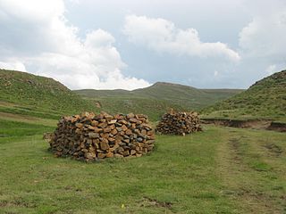
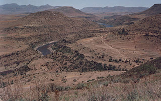
Lesotho is a mountainous, landlocked country located in Southern Africa. It is an enclave, surrounded by South Africa. The total length of the country's borders is 909 kilometres (565 mi). Lesotho covers an area of around 30,355 square kilometres (11,720 sq mi), of which a negligible percentage is covered with water.

<span class="mw-page-title-main">Politics of Lesotho</span>

Politics of Lesotho takes place in a framework of a parliamentary representative democratic constitutional monarchy, whereby the Prime Minister of Lesotho is the head of government, and of a multi-party system. Executive power is exercised by the government. Legislative power is vested in both the government and the two chambers of Parliament, the Senate and the National Assembly. The Judiciary is independent of the executive and the legislature.

<span class="mw-page-title-main">Free State (province)</span> Province in South Africa

The Free State, formerly known as the Orange Free State, is a province of South Africa. Its capital is Bloemfontein, which is also South Africa's judicial capital. Its historical origins lie in the Boer republic called the Orange Free State and later the Orange Free State Province.

<span class="mw-page-title-main">Berea District</span> District in Lesotho

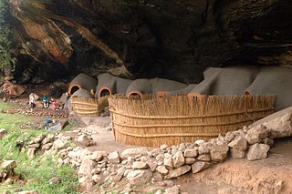
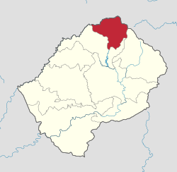
Berea is a district of Lesotho. In the west, Berea borders on the Free State Province of South Africa. Domestically, it borders on the following districts: Leribe District in the north, Thaba-Tseka District in southeast and Maseru District in the south. Teyateyaneng is the capital of the district. It is also home to the Kome Cave Dwellings. It is also the only district in Lesotho which is not named after its capital.

<span class="mw-page-title-main">Thaba-Tseka District</span> District in Lesotho

Thaba-Tseka is a district of Lesotho. Thaba-Tseka is also the name of the district's capital or camptown, which is the only town in the district. In the east, Thaba-Tseka borders on the KwaZulu-Natal Province of South Africa. Domestically, it borders on Mokhotlong District in northeast, Leribe District in north, Berea District in northwest, Maseru District in west, Mohale's Hoek District in southwest and Qacha's Nek District in the southern direction. The district is one of the major tourist attractions in Lesotho because of the second largest arch dam in Africa Katse Dam.

<span class="mw-page-title-main">Mokhotlong District</span> District in Lesotho

Mokhotlong district is a district of Lesotho. It includes the highest terrain in the Maloti Mountains and the source of the Senqu River, Lesotho's primary watershed. Mokhotlong is the capital or camptown, and only town in the district. Mokhotlong borders on the KwaZulu-Natal Province of South Africa, with its north point bordering the Free State Province. Domestically, it borders on Butha-Buthe District in northwest, Leribe District in west, and Thaba-Tseka District in the south.

<span class="mw-page-title-main">Leribe District</span> District in Lesotho

Leribè is a district of Lesotho. It has an area of 2,828 km2 and a population in 2016 of approximately 337,500. Hlotse is the capital or camptown of the district. The district has one additional town, namely Maputsoe. In the west, Leribe borders on the Free State Province of South Africa. Domestically, it borders Butha-Buthe District in the north, Mokhotlong District in the east, Thaba-Tseka District in southeast and Berea District in southwest.

<span class="mw-page-title-main">Mafeteng District</span> District in Lesotho

Mafeteng is a district of Lesotho. It has an area of 2,119 km2 and a population in 2016 of 178,222. Mafeteng is the capital or camptown, and only town in the district. In the west, Mafeteng borders on the Free State Province of South Africa. Domestically, it borders on the following districts Maseru District in the northeast and Mohale's Hoek District in the southeast.

<span class="mw-page-title-main">Maseru District</span> District of Lesotho

Maseru is a district of Lesotho. Maseru is also the name of the district's capital, and is the only city in the district and also the capital of the country. It is the largest urban area in the country, and therefore the only city. The city of Maseru is located on Lesotho's western border with the Free State Province of South Africa, the frontier being the Caledon River. Maseru borders on Berea District in north, Thaba-Tseka District in the east, Mohale's Hoek District in south, and Mafeteng District in southwest.

<span class="mw-page-title-main">Mohale's Hoek District</span> District in Lesotho

Mohale's Hoek is a district of Lesotho. Mohale's Hoek is the capital city or camptown, and only town in the district. In the southwest, Mohale's Hoek borders on South Africa, while domestically, it borders on Mafeteng District in northwest, Maseru District in north, Thaba-Tseka District in northeast, Qacha's Nek District in east, and Quthing District in southeast.

<span class="mw-page-title-main">Mokhotlong</span>

Mokhotlong is a constituency, city and seat of Mokhotlong District in the mountainous northeastern part of Lesotho. It is the first major city with an airport along the road from South Africa across the Sani Pass, near the Maloti Mountains. The name of the city is a word in Sesotho, the language of the people of Lesotho, meaning "Place of the Bald Ibis." Thabana Ntlenyana, the highest point in southern Africa, is found in Mokhotlong.

<span class="mw-page-title-main">Qacha's Nek District</span> District in Lesotho

Qacha's Nek is a district of Lesotho. Qacha's Nek is the capital or camptown, and only town in the district. In the south, Qacha's Nek borders on the Eastern Cape Province of South Africa, and it has a short border with KwaZulu-Natal Province in the far east. Domestically, it borders on Quthing District in southwest, Mohale's Hoek District in west and Thaba-Tseka District in the northern direction.

<span class="mw-page-title-main">Quthing District</span> District in Lesotho

Quthing is a district of Lesotho. Moyeni, is the camp town or capital of the district. There are two of the most important sets of dinosaur footprints in the region. There is a large panel of Bushman paintings at Qomoqomong. Quthing district is home to the Masitise Cave House, a satellite location of the Morija Museum & Archives. In the southwest, south and east, Quthing borders on the Eastern Cape Province of South Africa. Domestically, it borders Mohale's Hoek District in the north and Qacha's Nek District in the northeast.

<span class="mw-page-title-main">Lesotho Premier League</span> Football league

The Lesotho Premier League, also known as Econet Premier League for sponsorship reasons, is the top football division in Lesotho and was created in 1970. Econet Telecom Lesotho are the current league sponsor, since 2017/2018 season. Vodacom Lesotho were the previous league sponsor and were also the sponsor of the now cancelled Vodacom Soccer Spectacular knockout competition, which was the Lesotho's annual national cup tournament.

<span class="mw-page-title-main">Subdivisions of Lesotho</span>

Administratively, Lesotho is divided into ten districts, each headed by a district administrator. Each district has a capital known as a camptown.

Kao, Lesotho is a community council located in the Butha-Buthe District of Lesotho. Its population in 2006 was 5,304.

Likila is a community council located in the Butha-Buthe District of Lesotho. Its population in 2006 was 19,340.

Lipelaneng is a community council located in the Butha-Buthe and Leribe Districts of Lesotho. Its population in 2006 was 30,320.

Sekhobe is a community council located in the Butha-Buthe District of Lesotho. Its population in 2006 was 3,874.

References

  1. "Sub-national HDI - Area Database - Global Data Lab". hdi.globaldatalab.org. Retrieved 2018-09-13.
  2. "Population of Lesotho, 2006". Lesotho Bureau of Statistics. 2006. Retrieved 12 November 2016.
  3. "HID AIDS in Lesotho, 2004". Lesotho Bureau of Statistics. 2006. Retrieved 12 November 2016.
  4. Singh (29 September 2022). Geography. Tata McGraw-Hill Education. p. 12.64. ISBN   9781259063213.
  5. Tables A.6c and A.7c, Leribe Station, Tables_A_Geography.xls (XLS), Lesotho Bureau of Statistics, 2008
  6. Table A.5c, Leribe Station, Tables_A_Geography.xls (XLS), Lesotho Bureau of Statistics, 2008
  7. "Work profile in Lesotho, 2008". Lesotho Bureau of Statistics. 2008. Retrieved 12 November 2016.
  8. "Agricultural production in Lesotho, 2008". Lesotho Bureau of Statistics. 2009. Retrieved 12 November 2016.
  9. "Road and transport in Lesotho, 2008". Lesotho Bureau of Statistics. 2007. Retrieved 12 November 2016.
  10. "Village List". Lesotho Bureau of Statistics. Archived from the original on 13 November 2009. Retrieved 16 November 2016.
  11. Kapa, Motlamelle Anthony. Lesotho's local government system: A critical note on the structure and its implications for popular participation and service delivery (Report). Department of Political and International Studies,Rhodes University. pp. 8–12. CiteSeerX   10.1.1.528.8422 .
  12. Lesotho profile (PDF) (Report). CLGF. Retrieved 17 November 2016.

28°50′S28°30′E / 28.833°S 28.500°E / -28.833; 28.500