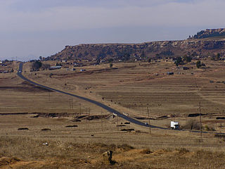
Lesotho, formally the Kingdom of Lesotho, is a landlocked country in Southern Africa. As an enclave of South Africa, with which it shares a 1,106 km border, it is the only sovereign enclave in the world outside of the Italian Peninsula. It is situated in the Maloti Mountains and contains the highest peak in Southern Africa. It has an area of over 30,000 km2 (11,600 sq mi) and has a population of about 2 million. Its capital and largest city is Maseru.

Lesotho is a mountainous, landlocked country located in Southern Africa. It is an enclave, surrounded by South Africa. The total length of the country's borders is 909 kilometres (565 mi). Lesotho covers an area of around 30,355 square kilometres (11,720 sq mi), of which a negligible percentage is covered with water.
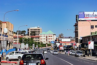
Maseru is the capital and largest city of Lesotho. It is also the capital of the Maseru District. Located on the Caledon River, Maseru lies directly on the Lesotho–South Africa border. Maseru had a population of 330,760 in the 2016 census. The city was established as a police camp and assigned as the capital after the country became a British protectorate in 1869. When the country achieved independence in 1966, Maseru retained its status as capital. The name of the city is a Sesotho word meaning "red sandstones".

The Free State, formerly known as the Orange Free State, is a province of South Africa. Its capital is Bloemfontein, which is also South Africa's judicial capital. Its historical origins lie in the Boer republic called the Orange Free State and later the Orange Free State Province.
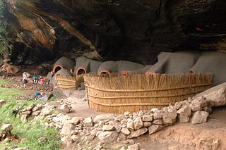
Berea is a district of Lesotho. In the west, Berea borders on the Free State Province of South Africa. Domestically, it borders on the following districts: Leribe District in the north, Thaba-Tseka District in southeast and Maseru District in the south. Teyateyaneng is the capital of the district. It is also home to the Kome Cave Dwellings. It is also the only district in Lesotho which is not named after its capital.

Butha-Buthe is a district of Lesotho. Butha-Buthe is the capital or camptown, and only town in the district. In the north, Butha-Buthe borders on the Free State Province of South Africa. Domestically, it borders on Mokhotlong District in southeast and Leribe District on the south.
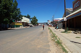
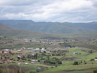
Hlotse is an important market town in Lesotho. It is situated on the Hlotse River, near the South African border. The town was founded in 1876 by a British missionary, Reverend John Widdicombe. It was a colonial centre until Lesotho gained its independence. The population in 2016 was 38,558.
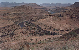
Thaba-Tseka is a district of Lesotho. Thaba-Tseka is also the name of the district's capital or camptown, which is the only town in the district. In the east, Thaba-Tseka borders on the KwaZulu-Natal Province of South Africa. Domestically, it borders on Mokhotlong District in northeast, Leribe District in north, Berea District in northwest, Maseru District in west, Mohale's Hoek District in southwest and Qacha's Nek District in the southern direction. The district is one of the major tourist attractions in Lesotho because of the second largest arch dam in Africa Katse Dam.

Mokhotlong district is a district of Lesotho. It includes the highest terrain in the Maloti Mountains and the source of the Senqu River, Lesotho's primary watershed. Mokhotlong is the capital or camptown, and only town in the district. Mokhotlong borders on the KwaZulu-Natal Province of South Africa, with its north point bordering the Free State Province. Domestically, it borders on Butha-Buthe District in northwest, Leribe District in west, and Thaba-Tseka District in the south.
Leribè is a district of Lesotho. It has an area of 2,828 km2 and a population in 2016 of approximately 337,500. Hlotse is the capital or camptown of the district. The district has one additional town, namely Maputsoe. In the west, Leribe borders on the Free State Province of South Africa. Domestically, it borders Butha-Buthe District in the north, Mokhotlong District in the east, Thaba-Tseka District in southeast and Berea District in southwest.

Mafeteng is a district of Lesotho. It has an area of 2,119 km2 and a population in 2016 of 178,222. Mafeteng is the capital or camptown, and only town in the district. In the west, Mafeteng borders on the Free State Province of South Africa. Domestically, it borders on the following districts Maseru District in the northeast and Mohale's Hoek District in the southeast.

Maseru is a district of Lesotho. Maseru is also the name of the district's capital, and is the only city in the district and also the capital of the country. It is the largest urban area in the country, and therefore the only city. The city of Maseru is located on Lesotho's western border with the Free State Province of South Africa, the frontier being the Caledon River. Maseru borders on Berea District in north, Thaba-Tseka District in the east, Mohale's Hoek District in south, and Mafeteng District in southwest.
Mohale's Hoek is a district of Lesotho. Mohale's Hoek is the capital city or camptown, and only town in the district. In the southwest, Mohale's Hoek borders on South Africa, while domestically, it borders on Mafeteng District in northwest, Maseru District in north, Thaba-Tseka District in northeast, Qacha's Nek District in east, and Quthing District in southeast.

Qacha's Nek is a district of Lesotho. Qacha's Nek is the capital or camptown, and only town in the district. In the south, Qacha's Nek borders on the Eastern Cape Province of South Africa, and it has a short border with KwaZulu-Natal Province in the far east. Domestically, it borders on Quthing District in southwest, Mohale's Hoek District in west and Thaba-Tseka District in the northern direction.
Quthing is a district of Lesotho. Moyeni, is the camp town or capital of the district. There are two of the most important sets of dinosaur footprints in the region. There is a large panel of Bushman paintings at Qomoqomong. Quthing district is home to the Masitise Cave House, a satellite location of the Morija Museum & Archives. In the southwest, south and east, Quthing borders on the Eastern Cape Province of South Africa. Domestically, it borders Mohale's Hoek District in the north and Qacha's Nek District in the northeast.
A camptown, in the country of Lesotho, refers to a district capital for one of the ten districts of Lesotho. The largest camptown is the city of Maseru in Maseru District. Camptowns are usually commerce hubs for the district and are the location for the central government offices for the district. Camptowns usually take the same name as the district in which they are located. For example, as mentioned the camptown for Maseru is Maseru but also the camptown for Thaba-Tseka District is Thaba-Tseka. The exceptions to this rule are Berea District whose capital is called Teyateyaneng, Quthing District whose capital is called Moyeni and Leribe District whose capital is most often called Hlotse.
Pitseng is a community council located in the Leribe District of Lesotho. The population in 2006 was 18,948.
The Lesotho Independence Cup is an annual knockout football competition in men's domestic football in Lesotho.

Administratively, Lesotho is divided into ten districts, each headed by a district administrator. Each district has a capital known as a camptown.
Leribe Airport is an airport serving Hlotse, the camptown (capital) of the Leribe District of Lesotho.