 |
|---|
The Kingdom of Lesotho is divided into 10 districts which are in turn divided into 80 constituencies. [1] [2]
| |
|---|
The Kingdom of Lesotho is divided into 10 districts which are in turn divided into 80 constituencies. [1] [2]

Lesotho, formally the Kingdom of Lesotho, is a landlocked country in Southern Africa. As an enclave of South Africa, with which it shares a 1,106 km (687 mi) border, it is the largest sovereign enclave in the world, and the only one outside of the Italian Peninsula. It is situated in the Maloti Mountains and contains the highest peak in Southern Africa. It has an area of over 30,000 km2 (11,600 sq mi) and has a population of about two million. Its capital and largest city is Maseru. The country is also known by the nickname The Mountain Kingdom.

Lesotho is a mountainous, landlocked country located in Southern Africa. It is an enclave, surrounded by South Africa. The total length of the country's borders is 909 kilometres (565 mi). Lesotho covers an area of around 30,355 square kilometres (11,720 sq mi), of which a negligible percentage is covered with water.

Politics of Lesotho takes place in a framework of a parliamentary representative democratic constitutional monarchy, whereby the Prime Minister of Lesotho is the head of government, and of a multi-party system. Executive power is exercised by the government. Legislative power is vested in both the government and the two chambers of Parliament, the Senate and the National Assembly. The Judiciary is independent of the executive and the legislature.
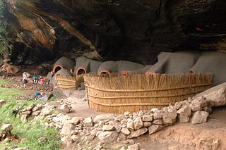
Berea is a district of Lesotho. In the west, Berea borders on the Free State Province of South Africa. Domestically, it borders on the following districts: Leribe District in the north, Thaba-Tseka District in southeast and Maseru District in the south. Teyateyaneng is the capital of the district. It is also home to the Kome Cave Dwellings. It is also the only district in Lesotho which is not named after its capital.
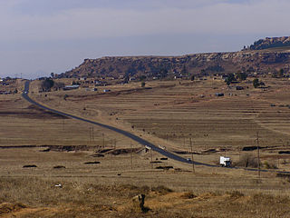
Thaba-Tseka is a district of Lesotho. Thaba-Tseka is also the name of the district's capital or camptown, which is the only town in the district. In the east, Thaba-Tseka borders on the KwaZulu-Natal Province of South Africa. Domestically, it borders on Mokhotlong District in northeast, Leribe District in north, Berea District in northwest, Maseru District in west, Mohale's Hoek District in southwest and Qacha's Nek District in the southern direction. The district is one of the major tourist attractions in Lesotho because of the second largest arch dam in Africa Katse Dam.
Thaba-Tseka is a constituency and the capital city or camptown of the Thaba-Tseka District in Lesotho. It has a population of 15,248.

Mokhotlong district is a district of Lesotho. It includes the highest terrain in the Maloti Mountains and the source of the Senqu River, Lesotho's primary watershed. Mokhotlong is the capital or camptown, and only town in the district. Mokhotlong borders on the KwaZulu-Natal Province of South Africa, with its north point bordering the Free State Province. Domestically, it borders on Butha-Buthe District in northwest, Leribe District in west, and Thaba-Tseka District in the south.
Leribè is a district of Lesotho. It has an area of 2,828 km2 and a population in 2016 of approximately 337,500. Hlotse is the capital or camptown of the district. The district has one additional town, namely Maputsoe. In the west, Leribe borders on the Free State Province of South Africa. Domestically, it borders Butha-Buthe District in the north, Mokhotlong District in the east, Thaba-Tseka District in southeast and Berea District in southwest.

Mafeteng is a district of Lesotho. It has an area of 2,119 km2 and a population in 2016 of 178,222. Mafeteng is the capital or camptown, and only town in the district. In the west, Mafeteng borders on the Free State Province of South Africa. Domestically, it borders on the following districts Maseru District in the northeast and Mohale's Hoek District in the southeast.

Maseru is a district of Lesotho. Maseru is also the name of the district's capital, and is the only city in the district and also the capital of the country. It is the largest urban area in the country, and therefore the only city. The city of Maseru is located on Lesotho's western border with the Free State Province of South Africa, the frontier being the Caledon River. Maseru borders on Berea District in north, Thaba-Tseka District in the east, Mohale's Hoek District in south, and Mafeteng District in southwest.

Mohale's Hoek is the capital city of Mohale's Hoek District in Lesotho. It had a population of approximately 40,040 in 2016.
Mohale's Hoek is a district of Lesotho. Mohale's Hoek is the capital city or camptown, and only town in the district. In the southwest, Mohale's Hoek borders on South Africa, while domestically, it borders on Mafeteng District in northwest, Maseru District in north, Thaba-Tseka District in northeast, Qacha's Nek District in east, and Quthing District in southeast.

Qacha's Nek is a district of Lesotho. Qacha's Nek is the capital or camptown, and only town in the district. In the south, Qacha's Nek borders on the Eastern Cape Province of South Africa, and it has a short border with KwaZulu-Natal Province in the far east. Domestically, it borders on Quthing District in southwest, Mohale's Hoek District in west and Thaba-Tseka District in the northern direction.

The Lesotho Defence Force (LDF) is the military of the Southern African Kingdom of Lesotho, which consists of about 2,000 personnel and is tasked with maintaining internal security, territorial integrity, and defending the constitution of Lesotho. Since the mountainous kingdom is completely landlocked by South Africa, in practice the country's external defence is guaranteed by its larger neighbour, so the armed forces are mainly used for internal security. The LDF is an army with a small air wing.

Motheo was, until the municipal elections of 18 May 2011, a district of the Free State province of South Africa. At the time of the 2011 elections it was disestablished as a consequence of Mangaung Local Municipality being upgraded to a metropolitan municipality.

Thaba Bosiu is a constituency and sandstone plateau with an area of approximately 2 km2 (0.77 sq mi) and a height of 1,804 meters above sea level. It is located between the Orange and Caledon Rivers in the Maseru District of Lesotho, 24 km east of the country's capital Maseru. It was once the capital of Lesotho, having been King Moshoeshoe's stronghold.

Administratively, Lesotho is divided into ten districts, each headed by a district administrator. Each district has a capital known as a camptown.

Bushbuckridge Municipality is a local municipality within the Ehlanzeni District Municipality, in the Mpumalanga province of South Africa. Commercial farming, which consists of pine and bluegum plantations, tobacco, cotton, sub-tropical fruits and vegetables, is practised in the municipality's countryside. The municipality includes the southern part of Kruger National Park. Bushbuckridge is the largest local municipality in Mpumalanga in terms of land size.
Thaba-Tseka Airport is an airport serving the town of Thaba-Tseka, the camptown of Thaba-Tseka District, Lesotho.
Mathibeli Edwin Mokhothu is a Mosotho educator and politician who served as the Deputy Prime Minister of the Kingdom of Lesotho, as well as the Minister of Parliamentary Affairs, from 2020 to 2022. A member of the Democratic Congress, he is the party's leader and previous deputy leader. He was formerly the Leader of the Opposition in the National Assembly before the party formed part of a coalition with the All Basotho Convention in May 2020. From 2015 to 2017, he served as the Minister of Gender, Youth, Sports and Recreation. Mokhothu is the MP for the Qhoali No. 68 constituency.