
Lesotho, formally the Kingdom of Lesotho, is a landlocked country in Southern Africa. As an enclave of South Africa, with which it shares a 1,106 km (687 mi) border, it is the largest sovereign enclave in the world, and the only one outside of the Italian Peninsula. It is situated in the Maloti Mountains and contains the highest peak in Southern Africa. It has an area of over 30,000 km2 (11,600 sq mi) and has a population of about two million. Its capital and largest city is Maseru. The country is also known by the nickname The Mountain Kingdom.

Lesotho is a mountainous, landlocked country located in Southern Africa. It is an enclave, surrounded by South Africa. The total length of the country's borders is 909 kilometres (565 mi). Lesotho covers an area of around 30,355 square kilometres (11,720 sq mi), of which a negligible percentage is covered with water.
This article concerns systems of transport in Lesotho. As a landlocked country, Lesotho has no seaports or harbours, but does have road, air transport, and limited rail infrastructure.
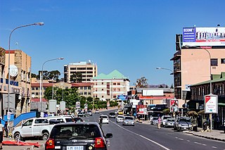
Maseru is the capital and largest city of Lesotho. It is also the capital of the Maseru District. Located on the Caledon River, Maseru lies directly on the Lesotho–South Africa border. Maseru had a population of 330,760 in the 2016 census. The city was established as a police camp and assigned as the capital after the country became a British protectorate in 1869. When the country achieved independence in 1966, Maseru retained its status as capital. The name of the city is a Sesotho word meaning "red sandstones".
Basutoland was a British Crown colony that existed from 1884 to 1966 in present-day Lesotho, bordered with the Cape Colony, Natal Colony and Orange River Colony until 1910 and completely surrounded by South Africa from 1910. Though the Basotho and their territory had been under British control starting in 1868, the Cape Colony was unpopular and unable to control the territory. As a result, Basutoland was brought under direct authority of Queen Victoria, via the High Commissioner, and run by an Executive Council presided over by a series of British Resident Commissioners.

Phuthaditjhaba, is a town in the Free State province of South Africa. It is located in a section of the Drakensberg mountains. It borders the province of KwaZulu-Natal to the south east and the independent country of Lesotho to the south west. The town was capital of the bantustan, or homeland, of QwaQwa. When apartheid ended, the town became part of the Free State province.

The Free State, formerly known as the Orange Free State, is a province of South Africa. Its capital is Bloemfontein, which is also South Africa's judicial capital. Its historical origins lie in the Boer republic called the Orange Free State and later the Orange Free State Province.

Mafeteng is a district of Lesotho. It has an area of 2,119 km2 and a population in 2016 of 178,222. Mafeteng is the capital or camptown, and only town in the district. In the west, Mafeteng borders on the Free State Province of South Africa. Domestically, it borders on the following districts Maseru District in the northeast and Mohale's Hoek District in the southeast.

Maseru is a district of Lesotho. Maseru is also the name of the district's capital, and is the only city in the district and also the capital of the country. It is the largest urban area in the country, and therefore the only city. The city of Maseru is located on Lesotho's western border with the Free State Province of South Africa, the frontier being the Caledon River. Maseru borders on Berea District in north, Thaba-Tseka District in the east, Mohale's Hoek District in south, and Mafeteng District in southwest.
Mohale's Hoek is a district of Lesotho. Mohale's Hoek is the capital city or camptown, and only town in the district. In the southwest, Mohale's Hoek borders on South Africa, while domestically, it borders on Mafeteng District in northwest, Maseru District in north, Thaba-Tseka District in northeast, Qacha's Nek District in east, and Quthing District in southeast.

The Caledon River is a major river located in central South Africa. Its total length is 642 km (399 mi), rising in the Drakensberg Mountains on the Lesotho border, flowing southwestward and then westward before joining the Orange River near Bethulie in the southern Free State. The river was originally named Prinses Wilhelminas Rivier in 1777, by Colonel R J Gordon.

Wepener is a town in the Free State, South Africa, located near the border of Lesotho.

Teyateyaneng is a town located in the district of Berea in Lesotho. Usually abbreviated to T.Y., Teyateyaneng takes its name from the two twin rivers which run on the north and the South. Both rivers lead to the Mohokare, or the Caledon River which forms the western boundary with South Africa. They are both named for their vast quantities of sand which means rapid dipping of feet as one crosses them, leading to both names which may well suggest that this is a 'place of quick sands'. Teyateyaneng's name therefore comes from the southern Teja-tejana River, but the name later changed to Teyateyaneng, perhaps due to British influences as the country became a Protectorate in the late 1800s.

Motheo was, until the municipal elections of 18 May 2011, a district of the Free State province of South Africa. At the time of the 2011 elections it was disestablished as a consequence of Mangaung Local Municipality being upgraded to a metropolitan municipality.
The Lesotho Premier League, also known as Vodacom Premier League for sponsorship reasons, is the top football division in Lesotho and was created in 1970. Econet Telecom Lesotho was the league sponsor, from 2017/2018 to 2019/2020 season. Vodacom Lesotho are again the current league sponsor and were also the sponsor of the now cancelled Vodacom Soccer Spectacular knockout competition, which was the Lesotho's annual national cup tournament.

Thaba Bosiu is a constituency and sandstone plateau with an area of approximately 2 km2 (0.77 sq mi) and a height of 1,804 meters above sea level. It is located between the Orange and Caledon Rivers in the Maseru District of Lesotho, 24 km east of the country's capital Maseru. It was once the capital of Lesotho, having been King Moshoeshoe's stronghold.

The nation of Lesotho has a single railway station, located in the capital city Maseru. It is the terminus of the Maseru branch line, which connects to the railway network of South Africa.

The border between Lesotho and South Africa is 909 kilometres (565 mi) long and forms a complete loop, as Lesotho is an enclave entirely surrounded by South Africa. The border follows the Caledon River, the drainage divide of the Drakensberg mountains, the Orange River, the Makhaleng River, and a series of hills joining the Makhaleng back to the Caledon.

The 2013 COSAFA U-20 Cup was the 22nd edition of the COSAFA U-20 Challenge Cup, an international youth competition open to national associations of the COSAFA region. It was the first time since 2011 that the competition took place, as the 2012 event was cancelled while COSAFA concentrated their effort into organising a football competition as part of the Zone Six Games.
Bantu Football Club is a Lesotho football club based in Mafeteng.


