Lesotho, formally the Kingdom of Lesotho, is a landlocked country in Southern Africa. As an enclave of South Africa, with which it shares a 1,106 km (687 mi) border, it is the largest sovereign enclave in the world, and the only one outside of the Italian Peninsula. It is situated in the Maloti Mountains and contains the highest peak in Southern Africa. It has an area of over 30,000 km2 (11,600 sq mi) and has a population of about two million. Its capital and largest city is Maseru. The country is also known by the nickname The Mountain Kingdom.

Lesotho is a mountainous, landlocked country located in Southern Africa. It is an enclave, surrounded by South Africa. The total length of the country's borders is 909 kilometres (565 mi). Lesotho covers an area of around 30,355 square kilometres (11,720 sq mi), of which a negligible percentage is covered with water.

The economy of Lesotho is based on tourism, manufacturing, mining, and agriculture, and depends heavily on remittances from its diaspora. Lesotho, a lower middle income country, is geographically surrounded by South Africa and is economically integrated with it as well. A significant portion of the population subsists on farming with a gradual ongoing transition into tourism and manufacturing.
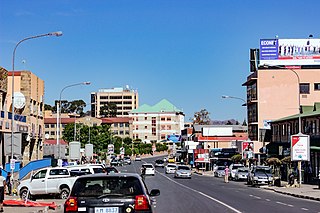
Maseru is the capital and largest city of Lesotho. It is also the capital of the Maseru District. Located on the Caledon River, Maseru lies directly on the Lesotho–South Africa border. Maseru had a population of 330,760 in the 2016 census. The city was established as a police camp and assigned as the capital after the country became a British protectorate in 1869. When the country achieved independence in 1966, Maseru retained its status as capital. The name of the city is a Sesotho word meaning "red sandstones".

South Africa occupies the southern tip of Africa, its coastline stretching more than 2,850 kilometres from the desert border with Namibia on the Atlantic (western) coast southwards around the tip of Africa and then northeast to the border with Mozambique on the Indian (eastern) coast. The low-lying coastal zone is narrow for much of that distance, soon giving way to a mountainous escarpment that separates the coast from the high inland plateau. In some places, notably the province of KwaZulu-Natal in the east, a greater distance separates the coast from the escarpment. Although much of the country is classified as semi-arid, it has considerable variation in climate as well as topography. The total land area is 1,220,813 km2 (471,359 sq mi). It has the 23rd largest Exclusive Economic Zone of 1,535,538 km2 (592,875 sq mi).

KwaZulu-Natal is a province of South Africa that was created in 1994 when the government merged the Zulu bantustan of KwaZulu and Natal Province.

The Drakensberg is the eastern portion of the Great Escarpment, which encloses the central Southern African plateau. The Great Escarpment reaches its greatest elevation – 2,000 to 3,482 metres within the border region of South Africa and Lesotho.

The Free State, formerly known as the Orange Free State, is a province of South Africa. Its capital is Bloemfontein, which is also South Africa's judicial capital. Its historical origins lie in the Boer republic called the Orange Free State and later the Orange Free State Province.

Mokhotlong district is a district of Lesotho. It includes the highest terrain in the Maloti Mountains and the source of the Senqu River, Lesotho's primary watershed. Mokhotlong is the capital or camptown, and only town in the district. Mokhotlong borders on the KwaZulu-Natal Province of South Africa, with its north point bordering the Free State Province. Domestically, it borders on Butha-Buthe District in northwest, Leribe District in west, and Thaba-Tseka District in the south.

Thabana Ntlenyana is the highest mountain in southern Africa. It stands 3,482 metres (11,424 ft) tall within the lofty Maloti Mountains that crest Lesotho, a small landlocked nation surrounded by South Africa. The peak's name means "beautiful little mountain" in the Sesotho language, from thaba (mountain), the diminutive -na, and ntlenyana (beautiful).

The Maloti-Drakensberg Park is a World Heritage Site, established on 11 June 2001 by linking the Sehlabathebe National Park in the Kingdom of Lesotho and the uKhahlamba Drakensberg Park in KwaZulu-Natal, South Africa. The highest peak is Thaba Ntlenyana rising to 3,482 metres.

Himeville is a small village/town situated in the foothills of the picturesque Southern Drakensberg, KwaZulu-Natal, South Africa, approx 130 km from Pietermaritzburg. It is a landmark en route to the world-famous Sani Pass and the uKhahlamba Drakensberg Park. Himeville is the closest town to the Sani Pass which links the town with Mokhotlong in Lesotho.

The Highveld is the portion of the South African inland plateau which has an altitude above roughly 1,500 m (4,900 ft), but below 2,100 m (6,900 ft), thus excluding the Lesotho mountain regions to the south-east of the Highveld. It is home to some of the country's most important commercial farming areas, as well as its largest concentration of metropolitan centres, especially the Gauteng conurbation, which accommodates one-third of South Africa's population.

Sani Pass is a mountain pass located in the West of KwaZulu-Natal, South Africa on the road between Himeville, KwaZulu-Natal and Mokhotlong, Lesotho. The pass traverses the Great Escarpment of southern Africa in its highest region, the Drakensberg Mountains, which reach an elevation of over 3,000 meters.

The Maloti Mountains are a mountain range of the highlands of the Kingdom of Lesotho. They extend for about 100 km into the South African Free State. The Maloti Range is part of the Drakensberg system that includes ranges across large areas of South Africa. "Maloti" is also the plural for Loti, the currency of the Kingdom of Lesotho. The range forms the northern portion of the boundary between the Butha-Buthe District in Lesotho and South Africa's Free State.
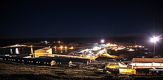
The Letšeng Diamond Mine, found in the landlocked Southern African kingdom of Lesotho, is owned by Gem Diamonds, Ltd. and the government of Lesotho, at an elevation of 3,100 m (10,200 ft) it is the world's highest diamond mine.

The uKhahlamba-Drakensberg Park is a protected area in the KwaZulu-Natal province of South Africa, covering 2,428.13 km2 (938 sq mi), and is part of the Maloti-Drakensberg Park, a World Heritage Site. The park includes Royal Natal National Park, a provincial park, and covers part of the Drakensberg, an escarpment formation with the highest elevations in southern Africa.

Matatiele Municipality is a local municipality within the Alfred Nzo District Municipality, in the Eastern Cape province of South Africa. It adjoins Lesotho to the north, Elundini to the south-west, and Greater Kokstad to the east and its 4,352 km² makes the Matatiele Municipality largest of four municipalities in the district at almost half of its geographical area. According to the South African National Census of 2011, its 203,483 residents and 49,527 households makes Matatiele Municipality the second largest populated area in the Alfred Nzo District Municipality behind Mbizana.
The Lighobong mine is one of the largest diamond mines in Lesotho and in the world. The mine is located in the northern part of the country near the Maloti Mountains. The mine has estimated reserves of 19 million carats of diamonds and an annual production capacity of 1 million carats.

The Lesotho Highlands are formed by the Drakensberg and Maloti mountain ranges in the east and central parts of the country of Lesotho. Foothills form a divide between the lowlands and the highlands. Snow is common in the highlands in the winter.