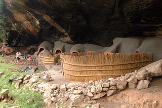
Berea is a district of Lesotho. In the west, Berea borders on the Free State Province of South Africa. Domestically, it borders on the following districts: Leribe District in the north, Thaba-Tseka District in southeast and Maseru District in the south. Teyateyaneng is the capital of the district. It is also home to the Kome Cave Dwellings. It is also the only district in Lesotho which is not named after its capital.
Semonkong is a community council located in the Maseru District of Lesotho. Semonkong, meaning "Place of Smoke", was established in the 1880s as a refuge for Basotho displaced by the Gun War. It is located close to several major natural features, including the Maletsunyane Falls and the 3096-metre peak of Thaba Putsoa. The population in 2006 was 7,781.
Mazenod is a community council located in the Maseru District of western Lesotho. The population in 2006 was 27,553. It is located to the south-east of the capital Maseru. Points of interest include Moshoeshoe I International Airport, Lesotho's only international airport.
Kanana is a community council located in the Berea District of Lesotho. Its population in 2006 was 19,311.
Kueneng is a community council located in the Berea District of Lesotho. Its population in 2006 was 21,887.
Makeoana is a community council located in the Berea District of Lesotho. Its population in 2006 was 33,445.
Maluba-Lube is a community council located in the Berea District of Lesotho. Its population in 2006 was 21,948.
Mapoteng is a community council located in the Berea District of Lesotho. Its population in 2006 was 23,926.
Kao, Lesotho is a community council located in the Butha-Buthe District of Lesotho. Its population in 2006 was 5,304.
Manka is a community council located in the Leribe District of Lesotho. Its population in 2006 was 20,693.

Koti-Se-Phola is a community council located in the Mafeteng District of Lesotho. Its population in 2006 was 12,391.
Makhaleng is a constituency located in the Maseru District of Lesotho. Its population in 2006 was 21,269.
Khoelenya is a community council located in the Mohale's Hoek District of Lesotho. Its population in 2006 was 22,424.
Khalahali is a community council located in the Mokhotlong District of Lesotho. Its population in 2006 was 8,220.
Khubelu is a community council located in the Mokhotlong District of Lesotho. Its population was 8,690 as of 2006.
Likhohlong is a community council located in the Quthing District of Lesotho. Its population in 2006 was 7,455.
Makheka is a community council located in the Maseru District of Lesotho. The population in 2006 was 5,473.
Lithoteng is a constituency and community council in the Maseru Municipality located in the Maseru District of Lesotho. The population in 2006 was 26,593.
Maseepho is a community council located in the Qacha's Nek District of Lesotho. Its population in 2006 was 7,879.
Matebeng is a community council located in the Qacha's Nek District of Lesotho. Its population in 2006 was 1,735.
