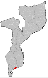
Inhassoro District is a district of Inhambane Province in south-east Mozambique. The district is located at the northeast of the province, and borders with Govuro District in the north, Vilanculos District in the southeast, Massinga District in the south, Funhalouro District in the southwest, and with Mabote District in the west. In the east, the district is bounded by the Indian Ocean. The area of the district is 4,480 square kilometres (1,730 sq mi). It has a population of 48,537 as of 2007.
Vilankulo District or Vilanculos District is a district of Inhambane Province in south-east Mozambique. Its principal town is Vilankulo. The district is located at the east of the province, and borders with Inhassoro District in the north and Massinga District in the south and in the west. In the east, the district is bounded by the Indian Ocean. The area of the district is 5,867 square kilometres (2,265 sq mi). It has a population of 135,710 as of 2007.

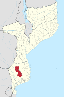
Chibuto District is a district of Gaza Province in south-western Mozambique. Its principal town is Chibuto. The district is located at the south of the province, and borders with Chigubo District in the north, Panda District of Inhambane Province in the east, Manjacaze District in the southeast, Xai-Xai District in the south, Chókwè District in the southwest, and Guijá District in the west. The area of the district is 5,653 square kilometres (2,183 sq mi). It has a population of 197,214 as of 2007.

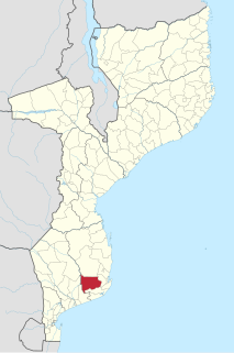
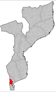
Manjacaze District is a district of Gaza Province in southwestern Mozambique. Its principal town is Manjacaze. The district is located at the south of the province, and borders with Panda District of Inhambane Province in the north, Inharrime and Zavala Districts of Inhambane Province in the east, Xai-Xai District in the south, and with Chibuto District in the west. In the southeast, the district is limited by the Indian Ocean. The area of the district is 3,797 square kilometres (1,466 sq mi). It has a population of 166,488 as of 2007.
Xai-Xai District is a district of Gaza Province in south-western Mozambique. The administrative center of the district is Chongoene. The district is located in the south of the province, and borders with Chibuto District in the north, Manjacaze District in the east, Bilene Macia District in the southeast, and with Chókwè District in the west. In the south, it is bounded by the Indian Ocean. The area of the district is 1,908 square kilometres (737 sq mi). It has a population of 188,720 as of 2007.
Chigubo District is a district of Gaza Province in south-western Mozambique. The administrative center of the district is Dindiza. The district is located in the east of the province, and borders with Massangena District in the north, Mabote and Funhalouro Districts of Inhambane Province in the east, Chibuto District in the south, Guijá District in the southwest, Mabalane District in the west, and with Chicualacuala District in the northwest. The area of the district is 14,864 square kilometres (5,739 sq mi). It has a population of 20,685 (2007).

Massangena District is a district of Gaza Province in south-western Mozambique. The administrative center of the district is Massangena. The district is located in the north of the province, and borders with Machaze District of Manica Province in the north, Mabote District of Inhambane Province in the east, Chigubo District in the southeast, Chicualacuala District in the south, and with Chiredzi District of Zimbabwe in the west. The area of the district is 7,481 square kilometres (2,888 sq mi). It has a population of 15,637 (2007).

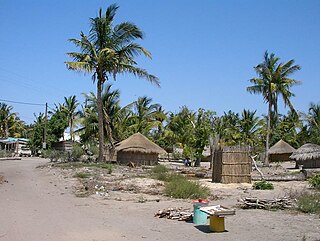
Zavala District is a district of Inhambane Province in south-east Mozambique. Its principal town is Zavala. The district is located at the east of the province, and borders with Inharrime District in the north and with Manjacaze District of Gaza Province in the west. In the east and in the south, the district is bounded by the Indian Ocean. The area of the district is 1,997 square kilometres (771 sq mi). It has a population of 139.616 as of 2007.
Funhalouro District is a district of Inhambane Province in south-east Mozambique. Its principal town is Funhalouro. The district is located at the west of the province, and borders with Mabote District in the north, Inhassoro District in the northeast, Massinga and Morrumbene Districts in the east, Homoine District in the southeast, Inharrime District in the south, and with Chigubo District of Gaza Province in the west. The area of the district is 13,653 square kilometres (5,271 sq mi). It has a population of 37.925 as of 2007.

Govuro District is a district of Inhambane Province in south-east Mozambique. Its principal town is Nova Mambone. The district is located at the northeast of the province, and borders with Machanga District of Sofala Province in the north, Inhassoro District in the south, and Mabote District in the west. In the east, the district is bounded by the Indian Ocean. The area of the district is 3,961 square kilometres (1,529 sq mi). It has a population of 34,809 as of 2007.
Homoine District is a district of Inhambane Province in south-east Mozambique. Its principal town is Vila de Homoine. The district is located at the east of the province, and borders with Morrumbene District in the north, Jangamo District in the southeast, Inharrime District in the south, Panda District in the west, and Funhalouro District in the northwest. In the east, the district is bounded by the Indian Ocean. The area of the district is 1,891 square kilometres (730 sq mi). It has a population of 107.475 as of 2007.
Jangamo District is a district of Inhambane Province in south-east Mozambique. Its principal town is Jangamo. The district is located in the south of the province, and borders with Homoine District in the north and with Inharrime District in the south and in the west. In the east, the district is bounded by the Indian Ocean. The area of the district is 1,294 square kilometres (500 sq mi). It has a population of 93,681 as of 2007.
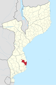
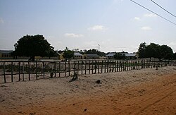
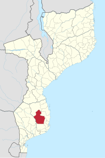
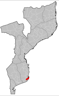
Massinga District is a district of Inhambane Province in south-east Mozambique. Its principal town is Massinga. The district is located at the east of the province and borders with Inhassoro District in the north, Vilanculos District in the northeast, Morrumbene District in the south, and with Funhalouro District in the west. In the east, the district is bounded by the Indian Ocean. The area of the district is 7,458 square kilometres (2,880 sq mi). In terms of the area, this is the biggest district of Inhambane Province. It has a population of 184,531 as of 2007.

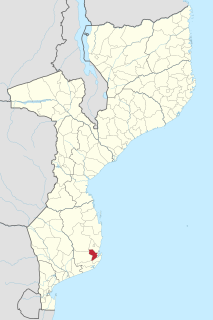
Morrumbene District is a district of Inhambane Province in south-east Mozambique. Its principal town is Morrumbene. The district is located at the east of the province and borders with Massinga District in the north, Homoine District in the south, and with Funhalouro District in the west. In the east, the district is bounded by the Indian Ocean. The area of the district is 2,608 square kilometres (1,007 sq mi). In terms of the area, this is the biggest district of Inhambane Province. It has a population of 124,471 as of 2007.
Panda District is a district of Inhambane Province in south-east Mozambique. Its principal town is Panda. The district is located at the northwest of the province and borders with Funhalouro District in the north, Homoine District in the east, Inharrime District in the south, and with Chibuto and Manjacaze Districts of Gaza Province in the west. The area of the district is 6,852 square kilometres (2,646 sq mi). It has a population of 47.946 as of 2007.

Machaze District is a district of Manica Province in western Mozambique. The principal town is Machaze. The district is located in the south of the province, and borders with Mossurize District in the north, Chibabava District of Sofala Province in the northeast, Machanga District of Sofala Province in the east, Mabote District of Inhambane Province in the south, Massangena District of Gaza Province in the southwest, and with Zimbabwe in the west. The area of the district is 13,189 square kilometres (5,092 sq mi). It has a population of 104,608 as of 2007.

Macossa District is a district of Manica Province in western Mozambique. The principal town is Macossa. The district is located in the east of the province, and borders with Tambara District in the north, Maringué District of Sofala Province in the northeast, Gorongosa District of Sofala Province in the east, Gondola District in the south, Báruè District in the west, and with Guro District in the northwest. The area of the district is 9,554 square kilometres (3,689 sq mi). It has a population of 27,245 as of 2007.

Mossurize District is a district of Manica Province in western Mozambique. The principal town is Espungabera. The district is located in the south of the province, and borders with Sussundenga District in the north, Chibabava District of Sofala Province in the east, Machaze District in the south, and with Zimbabwe in the west. The area of the district is 5,038 square kilometres (1,945 sq mi). It has a population of 195,182 as of 2007.
Moamba District is a district of Maputo Province in southern Mozambique. Its main town is Moamba. The district is located in the western part of the province, and borders with Magude District in the north, Manhiça and Marracuene Districts in the east, the city of Matola in the southeast, Boane District and Namaacha District in the south, and with Mpumalanga Province of South Africa, in the west. The area of the district is 4,628 square kilometres (1,787 sq mi). It has a population of 56,335 as of 2007.

Machanga District is a district of Sofala Province in Mozambique. The principal town is Machanga. The district is located in the south of the province, and borders with Buzi District in the north, Mabote and Govuro Districts of Inhambane Province in the south, Machaze District of Manica Province in the west, and with Chibabava District in the northwest. In the east, the district is limited by the Indian Ocean. The area of the district is 5,940 square kilometres (2,290 sq mi). It has a population of 51,855 as of 2007.