
Gorongosa District is a district of Sofala Province in Mozambique. The principal town is Gorongosa. The district is located in the northwest of the province, and borders with Maringué District in the north, Cheringoma District in the east, Muanza District in the southeast, Nhamatanda District in the south, and with Macossa and Gondola Districts of Manica Province in the west. The area of the district is 6,722 square kilometres (2,595 sq mi). It has a population of 116,912 as of 2007.

Chibuto District is a district of Gaza Province in south-western Mozambique. Its principal town is Chibuto. The district is located at the south of the province, and borders with Chigubo District in the north, Panda District of Inhambane Province in the east, Manjacaze District in the southeast, Xai-Xai District in the south, Chókwè District in the southwest, and Guijá District in the west. The area of the district is 5,653 square kilometres (2,183 sq mi). It has a population of 197,214 as of 2007.

Manjacaze District is a district of Gaza Province in southwestern Mozambique. Its principal town is Manjacaze. The district is located at the south of the province, and borders with Panda District of Inhambane Province in the north, Inharrime and Zavala Districts of Inhambane Province in the east, Xai-Xai District in the south, and with Chibuto District in the west. In the southeast, the district is limited by the Indian Ocean. The area of the district is 3,797 square kilometres (1,466 sq mi). It has a population of 166,488 as of 2007.

Massangena District is a district of Gaza Province in south-western Mozambique. The administrative center of the district is Massangena. The district is located in the north of the province, and borders with Machaze District of Manica Province in the north, Mabote District of Inhambane Province in the east, Chigubo District in the southeast, Chicualacuala District in the south, and with Chiredzi District of Zimbabwe in the west. The area of the district is 7,481 square kilometres (2,888 sq mi). It has a population of 15,637 (2007).

Funhalouro District is a district of Inhambane Province in south-east Mozambique. Its principal town is Funhalouro. The district is located at the west of the province, and borders with Mabote District in the north, Inhassoro District in the northeast, Massinga and Morrumbene Districts in the east, Homoine District in the southeast, Inharrime District in the south, and with Chigubo District of Gaza Province in the west. The area of the district is 13,653 square kilometres (5,271 sq mi). It has a population of 37.925 as of 2007.

Govuro District is a district of Inhambane Province in south-east Mozambique. Its principal town is Nova Mambone. The district is located at the northeast of the province, and borders with Machanga District of Sofala Province in the north, Inhassoro District in the south, and Mabote District in the west. In the east, the district is bounded by the Indian Ocean. The area of the district is 3,961 square kilometres (1,529 sq mi). It has a population of 34,809 as of 2007.

Inharrime District is a district of Inhambane Province in southeastern Mozambique. Its principal town is Inharrime. The district is located at the south of the province, and borders with Panda and Homoine Districts in the north, Jangamo District in the northwest, Zavala District in the south, and with Manjacaze District of Gaza Province in west. In the east, the district is bounded by the Indian Ocean. The area of the district is 2,744 square kilometres (1,059 sq mi). It has a population of 97.471 as of 2007.

Mabote District is a district of Inhambane Province in south-east Mozambique. Its principal town is Mabote. The district is located at the northwest of the province and borders with Machaze District of Manica Province and Machanga District of Sofala Province in the north, Govuro District in the east, Inhassoro District in the southeast, Funhalouro District in the south, and with Chigubo and Massangena Districts of Gaza Province in the west. The area of the district is 14,577 square kilometres (5,628 sq mi). In terms of the area, this is the biggest district of Inhambane Province. It has a population of 45101 as of 2007.
Massinga District is a district of Inhambane Province in south-east Mozambique. Its principal town is Massinga. The district is located at the east of the province and borders with Inhassoro District in the north, Vilanculos District in the northeast, Morrumbene District in the south, and with Funhalouro District in the west. In the east, the district is bounded by the Indian Ocean. The area of the district is 7,458 square kilometres (2,880 sq mi). In terms of the area, this is the biggest district of Inhambane Province. It has a population of 184,531 as of 2007.

Báruè District is a district of Manica Province in western Mozambique. Its principal town is Catandica. The district is located in the west of the province, and borders with Guro District in the north, Macossa District in the east, Gondola District in the southeast, Manica District in the south, and with Zimbabwe in the west. The area of the district is 5,743 square kilometres (2,217 sq mi). It has a population of 137,582 as of 2007.
Gondola District is a district of Manica Province in western Mozambique. The principal town is Gondola. The area of the district is 5,739 square kilometres (2,216 sq mi). It has a population of 262,412 as of 2007.

Macossa District is a district of Manica Province in western Mozambique. The principal town is Macossa. The district is located in the east of the province, and borders with Tambara District in the north, Maringué District of Sofala Province in the northeast, Gorongosa District of Sofala Province in the east, Gondola District in the south, Báruè District in the west, and with Guro District in the northwest. The area of the district is 9,554 square kilometres (3,689 sq mi). It has a population of 27,245 as of 2007.

Manica District is a district of Manica Province in western Mozambique. The principal town is Manica. The district is located in the west of the province, and borders with Báruè District in the north, Vanduzi District in the east, Sussundenga District in the south, and with Zimbabwe in the west. The area of the district is 4,594 square kilometres (1,774 sq mi). It has a population of 213,206 as of 2007.
Mossurize District is a district of Manica Province in western Mozambique. The principal town is Espungabera. The district is located in the south of the province, and borders with Sussundenga District in the north, Chibabava District of Sofala Province in the east, Machaze District in the south, and with Zimbabwe in the west. The area of the district is 5,038 square kilometres (1,945 sq mi). It has a population of 195,182 as of 2007.

Sussundenga District is a district of Manica Province in western Mozambique. The principal town is Sussundenga. The district is located in the center of the province, and borders with Manica District in the north, Gondola District in the northeast, Buzi District of Sofala Province in the east, Chibabava District of Sofala Province in the southeast, Mossurize District in the south, and with Zimbabwe in the west. The area of the district is 7,057 square kilometres (2,725 sq mi). It has a population of 129,851 as of 2007.

Tambara District is a district of Manica Province in western Mozambique. The principal town is Nhacolo. The district is located in the north of the province, and borders with Tete Province in the north, Chemba District of Sofala Province in the east, Maringué District of Sofala Province in the southeast, Macossa District in the south, and with Guro District in the west. The area of the district is 3,892 square kilometres (1,503 sq mi). It has a population of 41,339 as of 2007.

Chemba District is a district of Sofala Province in Mozambique. The principal town is Chemba. The district is located in the north of the province, and borders with Tete Province in the northeast, Caia District in the southeast, Maringué District in the southwest, and with Tambara District of Manica Province in the northwest. The area of the district is 3,998 square kilometres (1,544 sq mi). It has a population of 65,107 as of 2007.
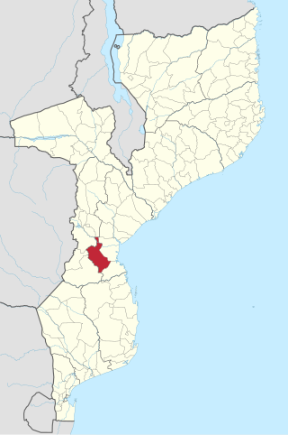
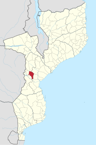
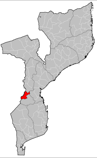
Chibabava District is a district of Sofala Province in Mozambique. The principal town is Chibabava. The district is located in the south of the province, and borders with Buzi District in the north, Machanga District in the southeast, with Machaze and Mossurize Districts of Manica Province in the west, and with Sussundenga District of Manica Province in the northwest. The area of the district is 6,977 square kilometres (2,694 sq mi). It has a population of 101,667 as of 2007.

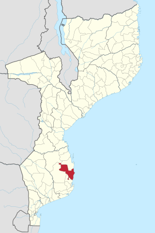
Machanga District is a district of Sofala Province in Mozambique. The principal town is Machanga. The district is located in the south of the province, and borders with Buzi District in the north, Mabote and Govuro Districts of Inhambane Province in the south, Machaze District of Manica Province in the west, and with Chibabava District in the northwest. In the east, the district is limited by the Indian Ocean. The area of the district is 5,940 square kilometres (2,290 sq mi). It has a population of 51,855 as of 2007.

Nhamatanda District is a district of Sofala Province in Mozambique. The principal town is Nhamatanda. The district is located in the center of the province, and borders with Gorongosa District in the north, Muanza District in the northeast, Dondo District in the east, Buzi District in the south, and with Gondola District of Manica Province in the west. The area of the district is 3,987 square kilometres (1,539 sq mi). It has a population of 210,757 as of 2007.
