
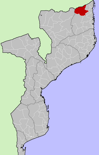
Mecula District is a district of Niassa Province in north-western Mozambique. The principal town is Mecula.
Part of the Niassa Reserve is located in this district.
Mecula District is a district of Niassa Province in north-western Mozambique. The principal town is Mecula.
Part of the Niassa Reserve is located in this district.
| | This Mozambique location article is a stub. You can help Wikipedia by expanding it. |

Cabo Delgado is the northernmost province of Mozambique. It has an area of 82,625 km² and a population of 2,320,261 (2017). As well as bordering the neighboring country of Tanzania, it borders the provinces of Nampula and Niassa. The region is an ethnic stronghold of the Makonde tribe, with the Makua and Mwani as leading ethnic minorities.

Niassa is a province of Mozambique. It has an area of 129,056 km2 and a population of 1,810,794 (2017). It is the most sparsely populated province in the country. Lichinga is the capital of the province. There are a minimum estimated 450,000 Yao people living in Mozambique. They largely occupy the eastern and northern part of the Niassa province and form about 40% of the population of Lichinga, the capital of this province.
Mueda is a district of the province of Cabo Delgado, in Moçambique. The capital is the town of Mueda.
Likoma District consists of two separate exclaves of Malawi situated within Mozambican waters in Lake Malawi. It consists of two main islands, Likoma and Chizumulu. It is a district in the Northern Region of Malawi. The capital is Likoma.

Cuamba is a city and district of Niassa Province in Mozambique, lying north west of Mount Namuli. Before independence the town was known as Nova Freixo.
Lichinga District is a district of Niassa Province in north-western Mozambique. The principal town is Lichinga.

Lago District is a district of Niassa Province in north-western Mozambique. The principal town is Metangula. Lago District is bordered to the west by Lake Nyasa, on the south by Lichinga, on the east by Sanga District. Lago shares its northern boundary with Tanzania.

Marrupa District is a district of Niassa Province in north-western Mozambique. The principal town is Marrupa.

Maúa District is a district of Niassa Province in north-western Mozambique. The principal town is Maúa.

Metarica District is a district of Niassa Province in north-western Mozambique. The principal town is Metarica.
Muembe District is a district of Niassa Province in north-western Mozambique. The principal town is Muembe.
Nipepe District is a district of Niassa Province in north-western Mozambique. The principal town is Nipepe.

Nhơn Trạch is a rural district of Đồng Nai Province in the Southeast region of Vietnam. As of 2003 the district had a population of 116,169. The district covers an area of 431 km². The district capital is at Phú Hội.
The electoral district of Allandale was an electoral district of the Legislative Assembly in the Australian state of Victoria, located north-west of Ballarat.

The Lugenda or Lujenda is a river of northern Mozambique. It flows in a south-north direction from Lake Amaramba/Lake Chiuta and is the largest tributary of the Ruvuma River. It joins the Luambala River at 13°26′12″S36°18′20″E. The river valley is reported to be only 800 feet (240 m) above sea level. North of Lake Chiuta, those on the west bank call it the Msambiti River. At one point, the Lugenda splits into several streams with islands between them, some of whom are populated such as the island Achemponda.

Negomano or Ngomano is a village in northern Mozambique, in Cabo Delgado Province. It is located on the border with Tanzania on the confluence of the Ruvuma River and the Lugenda River.

Melbourne Land District is a land district of Western Australia, located within the South West Division.
Murray Land District is a land district of Western Australia, located within the South-West Land Division on the state's west coast. It spans roughly 32°25'S - 32°56'S in latitude and 115°25'E - 116°30'E in longitude, and is located on the Indian Ocean coast, taking in the Shires of Murray and Waroona, the eastern part of the Serpentine-Jarrahdale and the western suburbs of Mandurah.
Paşamezrası is a village in the District of Adıyaman, Adıyaman Province, Turkey.

The electoral district of Warrenheip was an electorate of the Victorian Legislative Assembly in the British colony, and later Australian state, of Victoria. Created in 1889, the electorate was abolished in 1927 when it became the electoral district of Warrenheip and Grenville.