Sofala is a province of Mozambique. It has a population of 2,259,248. Beira is the capital of the province, named for the ruined port of Sofala which is 35 kilometres (22 mi) to the south.

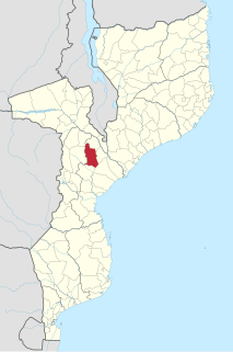
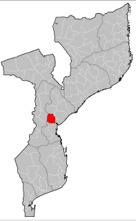
Gorongosa District is a district of Sofala Province in Mozambique. The principal town is Gorongosa. The district is located in the northwest of the province, and borders with Maringué District in the north, Cheringoma District in the east, Muanza District in the southeast, Nhamatanda District in the south, and with Macossa and Gondola Districts of Manica Province in the west. The area of the district is 6,722 square kilometres (2,595 sq mi). It has a population of 116,912 as of 2007.

Gondola District is a district of Manica Province in western Mozambique. The principal town is Gondola. The area of the district is 5,739 square kilometres (2,216 sq mi). It has a population of 262,412 as of 2007.

Machaze District is a district of Manica Province in western Mozambique. The principal town is Machaze. The district is located in the south of the province, and borders with Mossurize District in the north, Chibabava District of Sofala Province in the northeast, Machanga District of Sofala Province in the east, Mabote District of Inhambane Province in the south, Massangena District of Gaza Province in the southwest, and with Zimbabwe in the west. The area of the district is 13,189 square kilometres (5,092 sq mi). It has a population of 104,608 as of 2007.

Macossa District is a district of Manica Province in western Mozambique. The principal town is Macossa. The district is located in the east of the province, and borders with Tambara District in the north, Maringué District of Sofala Province in the northeast, Gorongosa District of Sofala Province in the east, Gondola District in the south, Báruè District in the west, and with Guro District in the northwest. The area of the district is 9,554 square kilometres (3,689 sq mi). It has a population of 27,245 as of 2007.

Mossurize District is a district of Manica Province in western Mozambique. The principal town is Espungabera. The district is located in the south of the province, and borders with Sussundenga District in the north, Chibabava District of Sofala Province in the east, Machaze District in the south, and with Zimbabwe in the west. The area of the district is 5,038 square kilometres (1,945 sq mi). It has a population of 195,182 as of 2007.

Sussundenga District is a district of Manica Province in western Mozambique. The principal town is Sussundenga. The district is located in the center of the province, and borders with Manica District in the north, Gondola District in the northeast, Buzi District of Sofala Province in the east, Chibabava District of Sofala Province in the southeast, Mossurize District in the south, and with Zimbabwe in the west. The area of the district is 7,057 square kilometres (2,725 sq mi). It has a population of 129,851 as of 2007.

Tambara District is a district of Manica Province in western Mozambique. The principal town is Nhacolo. The district is located in the north of the province, and borders with Tete Province in the north, Chemba District of Sofala Province in the east, Maringué District of Sofala Province in the southeast, Macossa District in the south, and with Guro District in the west. The area of the district is 3,892 square kilometres (1,503 sq mi). It has a population of 41,339 as of 2007.

Buzi District is a district of Sofala Province in Mozambique. The principal town is Búzi. The district is located in the southeast of the province, and borders with Nhamatanda District in the north, Dondo District in the northeast, Machanga District in the south, Chibabava District in the southwest, Sussundenga District of Manica Province in the west, and with Gondola District of Manica Province in the northwest. The area of the district is 7,329 square kilometres (2,830 sq mi). It has a population of 159,614 as of 2007.

Caia District is a district of Sofala Province in Mozambique. The principal town is Caia. The district is located in the north of the province, and borders with Chemba District in the north, Marromeu District in the southeast, Cheringoma District in the south, and with Maringué District in the west. In the east, the district is bounded by the Indian Ocean. The area of the district is 3,542 square kilometres (1,368 sq mi). It has a population of 115,455 as of 2007.

Chemba District is a district of Sofala Province in Mozambique. The principal town is Chemba. The district is located in the north of the province, and borders with Tete Province in the northeast, Caia District in the southeast, Maringué District in the southwest, and with Tambara District of Manica Province in the northwest. The area of the district is 3,998 square kilometres (1,544 sq mi). It has a population of 65,107 as of 2007.

Cheringoma District is a district of Sofala Province in Mozambique. The principal town is Inhaminga. The district is located in the northeast of the province, and borders with Caia District in the north, Marromeu District in the northeast, Muanza District in the south, Gorongosa District in the west, and with Maringué District in the northwest. In the south, it is bounded by the Indian Ocean. The area of the district is 6,954 square kilometres (2,685 sq mi). It has a population of 34,133 as of 2007.

Chibabava District is a district of Sofala Province in Mozambique. The principal town is Chibabava. The district is located in the south of the province, and borders with Buzi District in the north, Machanga District in the southeast, with Machaze and Mossurize Districts of Manica Province in the west, and with Sussundenga District of Manica Province in the northwest. The area of the district is 6,977 square kilometres (2,694 sq mi). It has a population of 101,667 as of 2007.

Machanga District is a district of Sofala Province in Mozambique. The principal town is Machanga. The district is located in the south of the province, and borders with Buzi District in the north, Mabote and Govuro Districts of Inhambane Province in the south, Machaze District of Manica Province in the west, and with Chibabava District in the northwest. In the east, the district is limited by the Indian Ocean. The area of the district is 5,940 square kilometres (2,290 sq mi). It has a population of 51,855 as of 2007.
Maringué District is a district of Sofala Province in Mozambique. The principal town is Maringué. The district is located in the north of the province, and borders with Chemba District in the north, Caia District in the east, Cheringoma District in the southeast, Gorongosa District in the south, with Macossa District of Manica Province in the west, and with Tambara District of Manica Province in the northwest. The area of the district is 6,176 square kilometres (2,385 sq mi). It has a population of 75,089 as of 2007.

Muanza District is a district of Sofala Province in Mozambique. The principal town is Muanza. The district is located in the center of the province, and borders with Cheringoma District in the north, Dondo District in the south, Nhamatanda District in the southwest, and with Gorongosa District in the northwest. In the east, the district is bordered by the Indian Ocean. The area of the district is 7,500 square kilometres (2,900 sq mi). It has a population of 25,229 as of 2007.
Nhamatanda District is a district of Sofala Province in Mozambique. The principal town is Nhamatanda. The district is located in the center of the province, and borders with Gorongosa District in the north, Muanza District in the northeast, Dondo District in the east, Buzi District in the south, and with Gondola District of Manica Province in the west. The area of the district is 3,987 square kilometres (1,539 sq mi). It has a population of 210,757 as of 2007.

Cahora-Bassa District is a district of Tete Province in western Mozambique. Its administrative center is the town of Chitima. The district is located in the southwest of the province, and borders with Marávia District in the north, Chiuta District in the northeast, Changara District in the east, Zimbabwe in the south, and with Magoé District in the west. The area of the district is 8,712 square kilometres (3,364 sq mi). It has a population of 89,956 as of 2007.
Chiuta District is a district of Tete Province in western Mozambique. The principal town is Manje. The district is located in the center of the province, and borders with Chifunde District in the north, Macanga District in the northeast, Tsangano District in the east, Moatize District in the southeast, Changara District in the south, Cahora-Bassa District in the southwest, and with Marávia District in the west. The area of the district is 6,887 square kilometres (2,659 sq mi). It has a population of 74,534 as of 2007.

Marávia District is a district of Tete Province in western Mozambique. Its administrative center is the town of Fingoé. The district is located in the northwest of the province, and borders with Zambia in the north, Chifunde District in the east, Chiuta District in the southeast, Cahora-Bassa District in the south, Magoé District in the southwest, and with Zumbo District in the west. The area of the district is 17,108 square kilometres (6,605 sq mi). It has a population of 82,789 as of 2007.