Related Research Articles
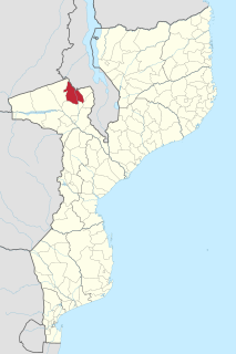
Macanga is a district situated in the north part of Tete Province in the central region of Mozambique. Its administrative center is the town of Furancungo. The district is located in the north of the province, and borders with Dedza District and Lilongwe District of Malawi in the north, Angónia District in the east, Tsangano District in the southeast, Chiuta District in the south, and with Chifunde District in the west. The area of the district is 6,999 square kilometres (2,702 sq mi). It has a population of 112,551 as of 2007.
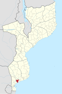
Bilene Macia District is a district of Gaza Province in south-western Mozambique. Its principal town is Macia. The district is located at the south of the province, and borders with Chókwè District in the north, Xai-Xai District in the east, and Magude District of Maputo Province in the west. In the south, the district is bounded by the Indian Ocean. The area of the district is 2,157 square kilometres (833 sq mi). It has a population of 151911 as of 2007.

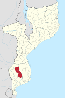
Chibuto District is a district of Gaza Province in south-western Mozambique. Its principal town is Chibuto. The district is located at the south of the province, and borders with Chigubo District in the north, Panda District of Inhambane Province in the east, Manjacaze District in the southeast, Xai-Xai District in the south, Chókwè District in the southwest, and Guijá District in the west. The area of the district is 5,653 square kilometres (2,183 sq mi). It has a population of 197,214 as of 2007.

Manjacaze District is a district of Gaza Province in southwestern Mozambique. Its principal town is Manjacaze. The district is located at the south of the province, and borders with Panda District of Inhambane Province in the north, Inharrime and Zavala Districts of Inhambane Province in the east, Xai-Xai District in the south, and with Chibuto District in the west. In the southeast, the district is limited by the Indian Ocean. The area of the district is 3,797 square kilometres (1,466 sq mi). It has a population of 166,488 as of 2007.
Chigubo District is a district of Gaza Province in south-western Mozambique. The administrative center of the district is Dindiza. The district is located in the east of the province, and borders with Massangena District in the north, Mabote and Funhalouro Districts of Inhambane Province in the east, Chibuto District in the south, Guijá District in the southwest, Mabalane District in the west, and with Chicualacuala District in the northwest. The area of the district is 14,864 square kilometres (5,739 sq mi). It has a population of 20,685 (2007).
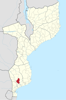
Guijá District is a district of Gaza Province in south-western Mozambique. The administrative center of the district is Caniçado. The district is located at the south of the province, and borders with Chigubo District in the north, Chibuto District in the east, Chókwè District in the south, and with Mabalane District in the west. The area of the district is 4,207 square kilometres (1,624 sq mi). It has a population of 75,303 as of 2007.

Báruè District is a district of Manica Province in western Mozambique. Its principal town is Catandica. The district is located in the west of the province, and borders with Guro District in the north, Macossa District in the east, Gondola District in the southeast, Manica District in the south, and with Zimbabwe in the west. The area of the district is 5,743 square kilometres (2,217 sq mi). It has a population of 137,582 as of 2007.

Gondola District is a district of Manica Province in western Mozambique. The principal town is Gondola. The area of the district is 5,739 square kilometres (2,216 sq mi). It has a population of 262,412 as of 2007.

Guro District is a district of Manica Province in western Mozambique. The principal town is Guro. The district is located in the north of the province, and borders with Changara District of Tete Province in the north, Tambara District in the east, Macossa District in the south, and Báruè District in the southwest. The area of the district is 6,928 square kilometres (2,675 sq mi). It had a population of 68,526 as of 2007 and 83,972 as of 2013

Macossa District is a district of Manica Province in western Mozambique. The principal town is Macossa. The district is located in the east of the province, and borders with Tambara District in the north, Maringué District of Sofala Province in the northeast, Gorongosa District of Sofala Province in the east, Gondola District in the south, Báruè District in the west, and with Guro District in the northwest. The area of the district is 9,554 square kilometres (3,689 sq mi). It has a population of 27,245 as of 2007.

Tambara District is a district of Manica Province in western Mozambique. The principal town is Nhacolo. The district is located in the north of the province, and borders with Tete Province in the north, Chemba District of Sofala Province in the east, Maringué District of Sofala Province in the southeast, Macossa District in the south, and with Guro District in the west. The area of the district is 3,892 square kilometres (1,503 sq mi). It has a population of 41,339 as of 2007.

Caia District is a district of Sofala Province in Mozambique. The principal town is Caia. The district is located in the north of the province, and borders with Chemba District in the north, Marromeu District in the southeast, Cheringoma District in the south, and with Maringué District in the west. In the east, the district is bounded by the Indian Ocean. The area of the district is 3,542 square kilometres (1,368 sq mi). It has a population of 115,455 as of 2007.

Chemba District is a district of Sofala Province in Mozambique. The principal town is Chemba. The district is located in the north of the province, and borders with Tete Province in the northeast, Caia District in the southeast, Maringué District in the southwest, and with Tambara District of Manica Province in the northwest. The area of the district is 3,998 square kilometres (1,544 sq mi). It has a population of 65,107 as of 2007.

Cheringoma District is a district of Sofala Province in Mozambique. The principal town is Inhaminga. The district is located in the northeast of the province, and borders with Caia District in the north, Marromeu District in the northeast, Muanza District in the south, Gorongosa District in the west, and with Maringué District in the northwest. In the south, it is bounded by the Indian Ocean. The area of the district is 6,954 square kilometres (2,685 sq mi). It has a population of 34,133 as of 2007.
Marromeu District is a district of Sofala Province in Mozambique. The principal town is Marromeu. The district is located in the northeast of the province, and borders with Chinde and Mopeia Districts of Zambezia Province in the north, Cheringoma District in the south and in the west, and with Caia District in the northwest. In the southeast, the district is limited by the Indian Ocean. The area of the district is 5,871 square kilometres (2,267 sq mi). It has a population of 119,718 as of 2007.

Cahora-Bassa District is a district of Tete Province in western Mozambique. Its administrative center is the town of Chitima. The district is located in the southwest of the province, and borders with Marávia District in the north, Chiuta District in the northeast, Changara District in the east, Zimbabwe in the south, and with Magoé District in the west. The area of the district is 8,712 square kilometres (3,364 sq mi). It has a population of 89,956 as of 2007.

Changara District is a district of Tete Province in western Mozambique. The principal town is Luenha. The district is located in the south of the province, and borders with Chiuta District in the north, Moatize District in the east, Guro District of Manica Province in the south, Zimbabwe in the southwest, and with Cahora-Bassa District in the west. The area of the district is 8,660 square kilometres (3,340 sq mi). It has a population of 156,738 as of 2007.

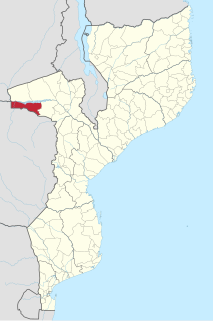
Chifunde District is a district of Tete Province in western Mozambique. The principal town is Chifunde. The district is located in the north of the province, and borders with Zambia in the north, Malawi in the northeast, Macanga District in the east, Chiuta District in the south, and with Marávia District in the west. The area of the district is 9,403 square kilometres (3,631 sq mi). It has a population of 101,811 as of 2007.
Magoé District is a district of Tete Province in western Mozambique. Its administrative center is the town of Mpheende. The district is located in the north of the province, and borders with Zumbo District in the north, Marávia District in the northeast, Cahora-Bassa District in the east, and with Zimbabwe in the south and in the west. The area of the district is 8,792 square kilometres (3,395 sq mi). It has a population of 70,614 as of 2007.

Marávia District is a district of Tete Province in western Mozambique. Its administrative center is the town of Fingoé. The district is located in the northwest of the province, and borders with Zambia in the north, Chifunde District in the east, Chiuta District in the southeast, Cahora-Bassa District in the south, Magoé District in the southwest, and with Zumbo District in the west. The area of the district is 17,108 square kilometres (6,605 sq mi). It has a population of 82,789 as of 2007.
References
- 1 2 3 4 5 6 7 8 "Perfil do Distrito de Chiuta" (PDF) (in Portuguese). Ministry of State Administration. 2005. Archived from the original (PDF) on 30 September 2011. Retrieved 24 November 2016.
- ↑ "População da Provincia de Tete". Censo 2007 (in Portuguese). Instituto Nacional de Estatística. Archived from the original on 19 December 2007. Retrieved 20 March 2008.