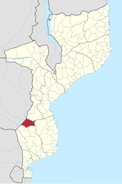
Gaza is a province of Mozambique. It has an area of 75,709 km2 and a population of 1,422,460, which is the least populous of all the provinces of Mozambique.
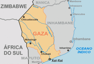
The Gaza Empire (1824–1895) was an African empire established by general Soshangane and was located in southeastern Africa in the area of southern Mozambique and southeastern Zimbabwe. The Gaza Empire, at its height in the 1860s, covered all of Mozambique between the Zambezi and Limpopo rivers, known as Gazaland.
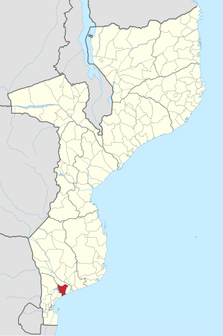
Bilene Macia District is a district of Gaza Province in south-western Mozambique. Its principal town is Macia. The district is located at the south of the province, and borders with Chókwè District in the north, Xai-Xai District in the east, and Magude District of Maputo Province in the west. In the south, the district is bounded by the Indian Ocean. The area of the district is 2,157 square kilometres (833 sq mi). It has a population of 151911 as of 2007.

Chibuto District is a district of Gaza Province in south-western Mozambique. Its principal town is Chibuto. The district is located at the south of the province, and borders with Chigubo District in the north, Panda District of Inhambane Province in the east, Manjacaze District in the southeast, Xai-Xai District in the south, Chókwè District in the southwest, and Guijá District in the west. The area of the district is 5,653 square kilometres (2,183 sq mi). It has a population of 197,214 as of 2007.
Chókwè District is a district of Gaza Province in south-western Mozambique. Its principal town is Chokwe. The district is located in the south of the province, and borders with Mabalane District in the north, Guijá District in the east, Chibuto, Xai-Xai, and Bilene Macia Districts in the southeast, Magude District of Maputo Province in the south, and with Massingir District in the west. The area of the district is 2,466 square kilometres (952 sq mi). It has a population of 187,422 (2007).

Manjacaze District is a district of Gaza Province in southwestern Mozambique. Its principal town is Manjacaze. The district is located at the south of the province, and borders with Panda District of Inhambane Province in the north, Inharrime and Zavala Districts of Inhambane Province in the east, Xai-Xai District in the south, and with Chibuto District in the west. In the southeast, the district is limited by the Indian Ocean. The area of the district is 3,797 square kilometres (1,466 sq mi). It has a population of 166,488 as of 2007.

Xai-Xai District is a district of Gaza Province in south-western Mozambique. The administrative center of the district is Chongoene. The district is located in the south of the province, and borders with Chibuto District in the north, Manjacaze District in the east, Bilene Macia District in the southeast, and with Chókwè District in the west. In the south, it is bounded by the Indian Ocean. The area of the district is 1,908 square kilometres (737 sq mi). It has a population of 188,720 as of 2007.

Chicualacuala District is a district of Gaza Province in south-western Mozambique. It has a population of 41,638 (2011) and covers 18,155 square kilometres (7,010 sq mi). The population density of Chicualacuala District 2.1 residents per square kilometers, significantly lower than the average of 17.5 in Gaza Province.

Chigubo District is a district of Gaza Province in south-western Mozambique. The administrative center of the district is Dindiza. The district is located in the east of the province, and borders with Massangena District in the north, Mabote and Funhalouro Districts of Inhambane Province in the east, Chibuto District in the south, Guijá District in the southwest, Mabalane District in the west, and with Chicualacuala District in the northwest. The area of the district is 14,864 square kilometres (5,739 sq mi). It has a population of 20,685 (2007).

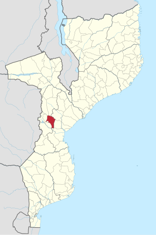
Guijá District is a district of Gaza Province in south-western Mozambique. The administrative center of the district is Caniçado. The district is located at the south of the province, and borders with Chigubo District in the north, Chibuto District in the east, Chókwè District in the south, and with Mabalane District in the west. The area of the district is 4,207 square kilometres (1,624 sq mi). It has a population of 75,303 as of 2007.

Mabalane District is a district of Gaza Province in south-western Mozambique. The administrative center of the district is Mabalane. The district is located at the center of the province, and borders with Chicualacuala District in the north, Chigubo District in the east, Guijá District in the southeast, Chókwè District in the south, and with Massingir District in the west. The area of the district is 9,107 square kilometres (3,516 sq mi). It has a population of 32,040 (2007).

Massingir District is a district of Gaza Province in southwestern Mozambique. The administrative center of the district is in Massingir. The district is located in the west of the province, and borders with Chicualacuala District in the north, Mabalane District in the east, Chókwè District in the southeast, Magude District of Maputo Province in the south, and with South Africa in the west. The area of the district is 5,893 square kilometres (2,275 sq mi). It has a population of 28,470 (2007).

Funhalouro District is a district of Inhambane Province in south-east Mozambique. Its principal town is Funhalouro. The district is located at the west of the province, and borders with Mabote District in the north, Inhassoro District in the northeast, Massinga and Morrumbene Districts in the east, Homoine District in the southeast, Inharrime District in the south, and with Chigubo District of Gaza Province in the west. The area of the district is 13,653 square kilometres (5,271 sq mi). It has a population of 37.925 as of 2007.

Inharrime District is a district of Inhambane Province in southeastern Mozambique. Its principal town is Inharrime. The district is located at the south of the province, and borders with Panda and Homoine Districts in the north, Jangamo District in the northwest, Zavala District in the south, and with Manjacaze District of Gaza Province in west. In the east, the district is bounded by the Indian Ocean. The area of the district is 2,744 square kilometres (1,059 sq mi). It has a population of 97.471 as of 2007.

Mabote District is a district of Inhambane Province in south-east Mozambique. Its principal town is Mabote. The district is located at the northwest of the province and borders with Machaze District of Manica Province and Machanga District of Sofala Province in the north, Govuro District in the east, Inhassoro District in the southeast, Funhalouro District in the south, and with Chigubo and Massangena Districts of Gaza Province in the west. The area of the district is 14,577 square kilometres (5,628 sq mi). In terms of the area, this is the biggest district of Inhambane Province. It has a population of 45101 as of 2007.
Gondola District is a district of Manica Province in western Mozambique. The principal town is Gondola. The area of the district is 5,739 square kilometres (2,216 sq mi). It has a population of 262,412 as of 2007.

Machaze District is a district of Manica Province in western Mozambique. The principal town is Machaze. The district is located in the south of the province, and borders with Mossurize District in the north, Chibabava District of Sofala Province in the northeast, Machanga District of Sofala Province in the east, Mabote District of Inhambane Province in the south, Massangena District of Gaza Province in the southwest, and with Zimbabwe in the west. The area of the district is 13,189 square kilometres (5,092 sq mi). It has a population of 104,608 as of 2007.

Machanga District is a district of Sofala Province in Mozambique. The principal town is Machanga. The district is located in the south of the province, and borders with Buzi District in the north, Mabote and Govuro Districts of Inhambane Province in the south, Machaze District of Manica Province in the west, and with Chibabava District in the northwest. In the east, the district is limited by the Indian Ocean. The area of the district is 5,940 square kilometres (2,290 sq mi). It has a population of 51,855 as of 2007.
Massangena is a river town in Massangena District of Gaza Province in south-western Mozambique. It lies on the river Save River (Africa).

Banhine National Park is a protected area in northern Gaza Province, Mozambique. The park was established on 26 June 1973. In 2013 the limits of Park were updated to better reflect the realities on the ground, particularly the human presence in the area.