Masvingo Province

Last updated

Masvingo Province
Victoria Province
Great-Zimbabwe-2.jpg
Great Zimbabwe ruins, found in the province.
Masvingo in Zimbabwe.svg
Masvingo, Province of Zimbabwe
Masvingo Elections08.gif
Masvingo constituency seats for the 2008 elections
Country Zimbabwe
Capital Masvingo
Establishedlate 19th century
Government
  Governor Josiah Dunira Hungwe (ZANU-PF)
Area
  Total56,566 km2 (21,840 sq mi)
Population
 (2022 census)
  Total1,638,528
  Density29/km2 (75/sq mi)
Time zone UTC+2 (CET)
  Summer (DST) UTC+2 (CEST)
HDI (2021)0.588 [1]
medium · 4th of 10

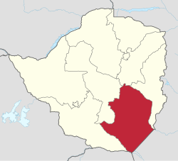
Masvingo, previously named Victoria, is a province in southeastern Zimbabwe. It has a population of 1.638 million as of the 2022 census, ranking fifth out of Zimbabwe's ten provinces. Established by the British South Africa Company, it was one of the five original provinces of Southern Rhodesia. In 1982, two years after Zimbabwean independence, it was renamed Masvingo Province. The province is divided into seven districts, including Masvingo District, which contains the provincial capital Masvingo City.

Contents

Masvingo Province is bordered by Matabeleland South Province to the southwest, Midlands Province to the northwest, Manicaland Province to the northeast, and Mozambique to the southeast. It has an area of 56,566 square kilometres (21,840 sq mi), equal to 14.48% of the total area of Zimbabwe. It is the third-largest in area of Zimbabwe's provinces, after Matabeleland North and Mashonaland West. A diverse province, the Karanga, a Shona subgroup, form the majority, with minorities of Shangani in the southeast and Ndebele in the west. Its economy is largely centred around agriculture and tourism. Masvingo Province is home to the Great Zimbabwe ruins, a World Heritage Site and major tourist attraction.

History

The town of Fort Victoria was founded in 1890 and was the first large settlement to be established by the Pioneer Column of the British South Africa Company which makes it the oldest town in Zimbabwe. It was named in honour of Queen Victoria.

The province is largely populated by members of the Karanga tribe, who are a sub-group of the Shona speaking tribes that also include the Zezuru, Manyika, and Ndau. The province is in the drier lowveldt area in the south of Zimbabwe. The boundaries were changed slightly in the 1980s. From white settlement until 2000 most of the area was devoted to cattle ranching, with mining and sugar cane growing (irrigated from Lake Mutirikwi), and communal areas where subsistence farming is carried out. With the land reforms of the early 21st century large scale cattle and mixed farms are being redistributed to small farmers.

Geography

Scenery along the A1 highway between Beitbridge & Masvingo, 2006 Kopje A1 Highway Masvingo.jpg
Scenery along the A1 highway between Beitbridge & Masvingo, 2006

Masvingo (formerly Fort Victoria) is the capital of the province. Chiredzi and Triangle are other major towns in the province. Other towns include Mashava and the newly upgraded Mpandawana which used to be a growth point. The province is dominated by the Save, Runde, Mwenezi and Limpopo river systems which all either join or drain directly into the Indian Ocean. Kopjes, grey and bald in the hot sun, dot the countryside. Mopane trees, drought tolerant and sturdy, are found throughout the province.

Climate

Masvingo province has a tropical savannah climate and is located in the low veld of the country where rainfall is minimal and uncertain. A large part of the southern area of the province is drought prone, set as region 5 in the country's climatic regions. Most parts of the province, therefore, are generally unfit for agriculture, apart from cattle ranching [2] [3] [4] Hippo Valley estates in Chiredzi and Triangle use the water from Lake Kyle for irrigation.

Demographics

Despite the aridness, the residents of the province are proud tillers of the earth and like most Bantu tribes in Southern Africa they practise animal husbandry to supplement their diets.

Masvingo has an area of 56,566 km2 and a population of approximately 1.3 million (2002). The Karanga form a majority of the province's population, Shona is the primary language. In Chiredzi District, there are communities of Shangani people while those of the Ndebele are found on the western edge of the province. To the north-east, are found the Ndau. The white population has declined since independence, especially during the invasions of commercial farms in 2000. In fact, the first farm invasion occurred in Masvingo Province and the rest of the country followed suit.

CensusPopulation [5]
20021,320,438
20121,485,090
20221,638,528

Government

The province's leader is a Minister for Provincial Affairs appointed by the country's president for a five-year term of office. The current Minister is Ezra Chadzamira appointed in 2018. The province also sends six elected members to the Senate plus a number of chiefs. In addition, twenty six members of parliament, selected from the province's seven districts, are sent to the House of Assembly.

Districts of Masvingo Masvingo districts.png
Districts of Masvingo

Districts

The districts are run by the rural district councils, which are composed of members elected from the wards in the district. Masvingo is divided into seven administrative districts, although these can be further divided by the delimitation committee during elections depending on population figures. The districts are Bikita, Chivi, Zaka and Masvingo in the center of the province, Gutu in the north, and Mwenezi, and Chiredzi in the south and east respectively. All these seven districts have business centres known as growth points except for Mpandawana (recently granted town status), and they are as follows with estimation of distance from Masvingo city centre: Masvingo- Nemanwa (30 km), Bikita- Nyika (82 km), Zaka- Jerera (96 km), Gutu- Mupandawana (94 km).

Elections

Masvingo was generally regarded as a stronghold of ZANU-PF, the ruling party. In the parliamentary elections of 2005, ZANU-PF won all but one district of the fourteen seats up for grabs. [6] For the election of March, 2008 the seven districts were redistributed into twenty-six constituencies. [7]

Economy

Tourism is a major contributor to the province's GDP, as is agriculture.

Mining

Transportation

Typical bus station scene in districts scattered across the province. At every bus station along the highway is found a retail shop. Retail Shop Masvingo.jpg
Typical bus station scene in districts scattered across the province. At every bus station along the highway is found a retail shop.

The busy A1 highway connects the major centers of Masvingo and Beitbridge.

Sports

Education

Masvingo has 2 Universities namely Great Zimbabwe University (GZU) and Reformed Church University. The Province also has Masvingo Politechnical College.

Masvingo Povince also has Margaretha Hugo School for the Blind (Copota) which is the first school for the visually impaired to be established in Zimbabwe.

Tourism

The province has a number of attractions. In the east of the province along the Mozambique border is Gonarezhou National Park, part of the Gaza, Kruger and Gonarezhou Transfrontier National Park concept. Less than an hour away to the east lies the world-famous stone ruins of Great Zimbabwe National Monument, from which Zimbabwe draws its name. A little closer to the stone ruins is Lake Kyle, a huge body of water where people spend time engaged in recreational actives in Mutirikwi Recreational Park. Tourism is a major contributor to the province's GDP, as is agriculture.

Notable people

The province has produced a number of notable figures in the history of Zimbabwe. These include Nelson Chamisa, leader of the MDC Alliance party, President Emmerson Mnangagwa who was raised in Chivi, Zimbabwe's current president, and Simon Muzenda;, [8] lawyer and politician Edson Zvobgo, Oxford-trained lawyer, Pearson Nherere, Paul Tangi Mhova Mkondo, businessman, Crispen Mandizvidza, ambassador Stan Mudenge and Alois Chidoda; Member of Parliament Shuvai Mahova; Chief Air-Marshall Josiah Tungamirai; Governor Josiah Hungwe. [9] The singer, Paul Matavire,was from Mwenezi, while Gen. Vitalis Zvinavashe, the second supreme commander of the Zimbabwe Defence Forces, is from Gutu. The first President of the Senate in Zimbabwe, Nolan Chipo Makombe is also from the province.

See also

Related Research Articles

<span class="mw-page-title-main">Matabeleland North Province</span> Province in Zimbabwe

Matabeleland North is a province in western Zimbabwe. With a population of 827,645 as of the 2022 census, it is the country's second-least populous province, after Matabeleland South, and is the country's least densely populated province. Matabeleland North and Matabeleland South were established in 1974, when the original Matabeleland Province was bifurcated. In 1997, the province lost territory when the city of Bulawayo became a province in its own ight. Matabeleland North is divided into seven districts. Its capital is Lupane, and Victoria Falls and Hwange its largest towns. The name "Matabeleland" is derived from the Matabele or Ndebele people, the province's largest ethnic group.

<span class="mw-page-title-main">Matabeleland South Province</span> Province in Zimbabwe

Matabeleland South is a province in southwestern Zimbabwe. With a population of 683,893 as of the 2012 Zimbabwean census, it is the country's least populous province. After Matabeleland North, it is Zimbabwe's second-least densely populated province. Matabeleland South and Matabeleland North were established in 1974, when the original Matabeleland Province was bifurcated. The province is divided into six districts. Gwanda is the capital, and Beitbridge is the province's largest town. The name "Matabeleland" is derived from Ndebele, the province's largest ethnic group.

<span class="mw-page-title-main">Eddison Zvobgo</span> Founder of Zimbabwes ruling party, ZANU–PF (1935–2004)

Eddison Jonasi Mudadirwa Zvobgo was a Zimbabwean politician and the founder of Zimbabwe's ruling party, ZANU–PF. He was the ZANU-PF's spokesman at the Lancaster House in late 1979., a Harvard-educated lawyer, a freedom fighter, a national hero, a hotelier, and a poet.

<span class="mw-page-title-main">Gonarezhou National Park</span> National park in Zimbabwe

Gonarezhou National Park is a national park located in southeastern Zimbabwe. It is situated in a relatively remote corner of Masvingo Province, south of Chimanimani along the Mozambique border. Owing to its vast size, rugged terrain and its location away from main tourist routes, large tracts of Gonarezhou remain pristine wilderness.

The Ndau are an ethnic group which inhabits the areas in south-eastern Zimbabwe in the districts of Chipinge and Chimanimani in which they are natives. They are also found in parts of Bikita, in the Zambezi valley, in central Mozambique all the way to the coast and in central Malawi. The name "Ndau" means Land. Just like the Manyika people in northern Manicaland, their name Manyika also meaning "Owners of the Land", the name Ndau means Land. E.g "Ndau yedu" meaning "our land" When the Ngoni observed this, they called them the Ndau people, the name itself meaning the land, the place or the country in their language. Some suggestions are that the name is derived from the Nguni words "Amading'indawo" which means "those looking for a place" as this is what the Gaza Nguni called them and the name then evolved to Ndau. This is erroneous as the natives are described in detail to have already been occupying parts of Zimbabwe and Mozambique in 1500s by Joao dos Santos. The five largest Ndau groups are the Magova; the Mashanga; the Vatomboti, the Madanda and the Teve. Ancient Ndau People met with the Khoi/San during the first trade with the Arabs at Mapungumbwe and its attributed to the Kalanga people not Ndau. They traded with Arabs with “Mpalu” “Njeti” and “Vukotlo’’ these are the red, white and blue coloured cloths together with golden beads. Ndau people traded traditional herbs, spiritual powers, animal skins and bones.

<span class="mw-page-title-main">Bikita District</span> District in Masvingo, Zimbabwe

Bikita is a district in Masvingo Province in Zimbabwe. It borders with Gutu District, Zaka District, Chipinge District, Chiredzi District, Buhera District and Mwenezi District. It is located about 80 kilometres (50 mi) east of Masvingo town. Its administration is at Nyika Growth Point but initially it was at Bikita Office, 10 km south of Nyika Growth Point towards Jerera Growth Point in Zaka District.

<span class="mw-page-title-main">Zaka District</span> District in Masvingo, Zimbabwe

Zaka is a district in Masvingo Province, Zimbabwe, located 86 km southeast of Masvingo. Old administration offices were at Ndanga communal (Chimutarara) township before being moved to its current location, Zaka Business Centre. Among its schools are St. Anthony's High School, Jichidza Mission, Rudhanda High School, and Wasarawapata High School.

<span class="mw-page-title-main">2000 Zimbabwean parliamentary election</span>

Parliamentary elections were held in Zimbabwe on 24 and 25 June 2000 to elect members of the House of Assembly. The electoral system involved 120 constituencies returning one member each, elected by the First Past the Post system, with the President of Zimbabwe then nominating 20 members and ten further members from the Tribal Chiefs sitting ex officio. This was the first national election in which Zimbabwe's ruling ZANU-PF party had faced any real opposition since the 1980s. The newly formed Movement for Democratic Change challenged Mugabe's control of parliament. The MDC won 57 of the 120 elected seats, with 47% of the popular vote. Zanu-PF won 63 seats and carried approximately 48% of the popular vote.

<span class="mw-page-title-main">Districts of Zimbabwe</span>

The Republic of Zimbabwe is broken down into 10 administrative provinces, which are divided into 64 districts and 1,970 wards.

<span class="mw-page-title-main">Chivi District</span> District in Masvingo, Zimbabwe

Chivi, originally known as Chibi, is a district in the Masvingo Province of Zimbabwe. The area was originally established as a mission station in 1894 by the Berlin Missionary Society under the name Chibi Mission.

<span class="mw-page-title-main">Mberengwa District</span> Administrative district in Midlands, Zimbabwe

Mberengwa, originally known as Belingwe, is a district in Midlands province in Zimbabwe. The district is now divided into sub-districts: Mberengwa North, East, West and South. It is bounded by Gwanda in Mberengwa west, and by Zvishavane in its northern zone, to the south it stretches to Neshuro, Chikombedzi and bounded by Manyuchi dam.

<span class="mw-page-title-main">Mwenezi District</span> District in Masvingo, Zimbabwe

Mwenezi, originally known as Nuanetsi, is a small district situated in southern Zimbabwe. It is bisected by the Mwenezi River and the A4 highway, the main thoroughfare that connects the town of Beitbridge, on the border with South Africa, to Masvingo.

<span class="mw-page-title-main">Chiredzi District</span> District in Masvingo, Zimbabwe

A district in Zimbabwe, Masvingo Province

Dr. Samuel Creighton Mumbengegwi was a Zimbabwean politician who served for a time as Minister of Higher Education and as ZANU-PF Chairperson. He was the brother of the former Minister of Foreign Affairs, Dr. Simba Mumbengegwi.

<span class="mw-page-title-main">Gutu District</span> District in Masvingo, Zimbabwe

Gutu is the third largest district in Masvingo Province, southern Zimbabwe, after Chiredzi and Mwenezi. It is the northernmost district in the province. The name "Gutu" is historically reported to have emerged from "Chinomukutu wemiseve" – meaning, "the one with a load of arrows". This is according to oral historical folklore of the "Gumbo" clan who are said to have taken over the area from the "Shiri" clan through killing them by poisoning the fruit trees in the "Gona" area. Mupandawana is the largest district service centre. It was designated as a "growth point" during the early years of independent Zimbabwe together with such places as Gokwe in the Midlands Province and Juru in Mashonaland East province. Mpandawana gained town status in April 2014.

<span class="mw-page-title-main">Masvingo District</span> District in Masvingo, Zimbabwe

Masvingo, originally Victoria, encampases metropolitan Masvingo, in Masvingo Province in southern Zimbabwe. The district boasts of the Great Zimbabwe National Monument among its list of tourist attractions. Lake Kyle is also nearby. The people in the district are mostly rural, communal farmers. Mushandike Co-op. is found in the district, in which the villagers use the water from Tokwe River to irrigate their patches of land. Ngomahuru Hospital which is the second largest Psychiatric hospital in the country is also located.

Gutu West is a constituency represented in the National Assembly of the Parliament of Zimbabwe, located in Gutu District in Masvingo Province. Its current MP since the 2023 election is John Paradza of ZANU–PF. It is predominantly Karanga, Ndau and Hera constituency.

References

  1. "Sub-national HDI - Area Database - Global Data Lab". hdi.globaldatalab.org. Retrieved 13 September 2018.
  2. However the low veld has a thriving sugar industry which is fed by Mutirkwi and Tugwi-Mukosi river systems. Sugar produces in this area satisfies local demand and is exported to neighboring countries. Millions in need of food aid (accessed 17 February 2008)
  3. Experiment success (accessed 17 February 2008)
  4. Harsh Times (accessed 17 February 2008)
  5. "Zimbabwe: Administrative Division (Provinces and Districts) - Population Statistics, Charts and Map". www.citypopulation.de. Retrieved 17 February 2024.
  6. "Results for Parliamentary Elections March 31, 2005". Zimbabwe Election Commission. April 2005. Archived from the original on 31 July 2007.
  7. "Mbeki meets Zim's political leaders". BuaNews. 17 January 2008. Archived from the original on 16 July 2011.
  8. Shaw, Angus (20 September 2003). "Frail Zimbabwe Vice President Dies at 80". Archived from the original on 12 April 2014.
  9. Mangwende, Brian (2 October 2003). "Zimbabwe: Zanu PF Split Over Zvobgo". The Financial Gazette. Harare, Zimbabwe. Archived from the original on 8 October 2003.(accessed 17 February 2008)

21°00′S31°00′E / 21.000°S 31.000°E / -21.000; 31.000