
Hwange District is an administrative district in northwestern Zimbabwe, in southern Africa. [1]
Hwange District is an administrative district in northwestern Zimbabwe, in southern Africa. [1]
The district is located in Matabeleland North Province, in northwest Zimbabwe, bordering Botswana and the Republic of Zambia. Its main town, Hwange, is located about 100 kilometres (62 mi), by road, southeast of Victoria Falls, the nearest large city. [2]
Hwange District is primarily a mining district. Large coal deposits are found in the district and several large coal mines are located there, including Hwange Colliery, the largest coal mine in Zimbabwe. The district headquarters is located in Hwange, a city which lies of the Bulawayo-Victoria Falls Road (A8 Highway), with an estimated population of 33,210 as of 2004. [3]
The current population of Hwange District is 62,670. [4]

Matabeleland North is a province in western Zimbabwe. With a population of 749,017 as of the 2012 census, it is the country's second-least populous province, after Matabeleland South, and is the country's least densely populated province. Matabeleland North was established in 1974, when the original Matabeleland Province was divided into two provinces, the other being Matabeleland South. In 1997, the province lost territory when the city of Bulawayo became a province in its own ight. Matabeleland North is divided into seven districts. Its capital is Lupane, and Victoria Falls and Hwange its largest towns. The name "Matabeleland" is derived from the Matabele or Ndebele people, the province's largest ethnic group.

Matabeleland is a region located in southwestern Zimbabwe that is divided into three provinces: Matabeleland North, Bulawayo, and Matabeleland South. These provinces are in the west and south-west of Zimbabwe, between the Limpopo and Zambezi rivers and are further separated from Midlands by the Shangani River in central Zimbabwe. The region is named after its inhabitants, the Ndebele people who were called "Amatabele"(people with long spears – Mzilikazi 's group of people who were escaping the Mfecani wars). Other ethnic groups who inhabit parts of Matabeleland include the Tonga, Bakalanga, Venda, Nambya, Khoisan, Xhosa, Sotho, Tswana, and Tsonga. The population of Matabeleland is just over 20% of the Zimbabwe's total.
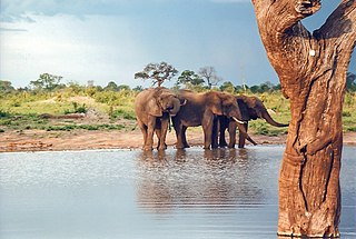
Hwange National Park is the largest natural reserve in Zimbabwe. It is around 14,600 sq km in area. It lies in the northwest of the country, just off the main road between Bulawayo and Victoria Falls. The nearest town is Dete. Histories of the region's pre-colonial days and its development as a game reserve and National Park are available online
Hwange, originally known as Wankie, is a town in Zimbabwe, located in Hwange District, in Matabeleland North Province, in northwestern Zimbabwe, close to the international borders with Botswana and Zambia. It lies approximately 100 kilometres (62 mi), by road, southeast of Victoria Falls, the nearest large city. The town lies on the railway line from Bulawayo, Zimbabwe's second-largest city, to Victoria Falls. Hwange sits at an elevation of 770 metres (2,530 ft), above sea level.

Victoria Falls, popularly known as Vic Falls, is a resort town and city in the province of Matabeleland North, Zimbabwe. It lies on the southern bank of the Zambezi River at the western end of Victoria Falls themselves. According to the 2022 Population Census, the town had a population of 35,199.

Beitbridge is a border town in the province of Matabeleland South, Zimbabwe. The name also refers to the border post and bridge spanning the Limpopo River, which forms the political border between South Africa and Zimbabwe. The border on the South African side of the river is also named Beitbridge.
Lonely Mine is a village in Matabeleland North, Zimbabwe and is located about 84 kilometres (52 mi) north-east of Bulawayo, just north of Inyati. It was established in 1906 when gold was discovered in the area. Gold, nickel and tungsten are still mined in the area today.
Matetsi is a village in Matabeleland North, Zimbabwe and is located about 55 km west of Hwange. The village started as a railway siding and took its name from the nearby Matetsi River. Most of the surrounding land is under forest and the Matetsi Safari Area. The nearest airports are Victoria Falls (Zimbabwe), Kasane (Botswana), and Livingstone (Zambia)

Tsholotsho, originally known as Tjolotjo, is a district in Matabeleland North province in Zimbabwe. Its administrative centre is at Tsholotsho business centre which is located about 98 km north-west of Bulawayo. Districts around Tsholotsho include Lupane, Hwange, Umguza, and Bulilima. The Manzamnyama River separates Tsholotsho from Bulilima District, whilst the Gwayi River separates it from Umguza and Lupane districts, and the Hwange National Park separates it from Hwange District.
Colleen Bawn is a town in Zimbabwe.
Plumtree is a town in Zimbabwe. Marula trees, wild plum trees grow abundantly in the area. The town was once called Getjenge by baKalanga. Another name by which it is often caled, is Titji, meaning station and referring to the railway station which was operating in the area around 1897.

Marist Brothers Secondary School, Dete (MBSS), otherwise referred to as 'Marist Dete' is a co-educational (mixed) boarding secondary school Dete, in the Hwange district of Zimbabwe’s Matabeleland North Province. The school was established in 1972 and is part of the international family of Marist schools run by the Marist Brothers, a Catholic society founded in 1817 by Saint Marcellin Champagnat in France.
Lupane ( luːpɑːnɛ) District is located in the Matabeleland North Province of Zimbabwe, and it is also the Provincial Capital. The District is situated at an elevation of 976 m with a population of 198,600 inhabitants by 2019. Lupane Town is the main center of the district located 172 km from Bulawayo along the A8 Victoria Falls Road. The Government Provincial Administrative offices are located at the Town Centre. A new university near the Town has been established under the name Lupane State University, which caters for the region and beyond. The word Lupane is thought to be a Kalanga or Lozwi word.
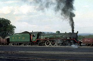
Hwange Colliery Company Limited is the name of a company in Zimbabwe and of its associated coal mining, processing and marketing. It was founded in 1899. Mining operations are located near Hwange in the province of Matabeleland North. The company's headquarters are in Hwange and registered office the capital Harare and a regional office in Bulawayo.Its stock is listed on the Zimbabwe Stock Exchange and is a component of its stock index, the Zimbabwe Mining Index. It is also listed on the London Stock Exchange and Johannesburg Stock Exchange.
Zimbabwe Electricity Supply Authority, (ZESA) whose official name is ZESA Holdings (Private) Limited, is a state-owned company whose task is to generate, transmit, and distribute electricity in Zimbabwe. It has organized this task by delegation to its subsidiaries, the energy generating company Zimbabwe Power Company (ZPC) and the Zimbabwe Electricity Transmission and Distribution Company (ZETDC). Other subsidiaries are the investment branch ZESA Enterprises (ZENT) and internet provider PowerTel Communications (Private) Limited. ZESA is the only electricity generator and supplier for the public grid. For many years the company has failed to produce enough energy to meet demands. ZESA produced an estimated 6.8 billion kWh in 2016, while demand was estimated at 7.118 billion kWh. ZESA represents Zimbabwe in the Southern African Power Pool.
Bubi is a district in Matabeleland North in Zimbabwe. It is rich in minerals, but lacks infrastructure. Its 2012 census population was 61,883; and had grown to 74,084 by 2022.

Bulilimamangwe District was a former district in Zimbabwe. In 2003 it was subdivided into three districts: Bulilima District, Mangwe District and Plumtree Town. At the time of its dissolution the area had a population of just under 300,000.
The A8 Highway is a paved primary trunk road in Zimbabwe running from Bulawayo to Victoria Falls. It is managed by the Zimbabwe National Roads Administration (ZINARA). It is part of the R9 Route, which links Victoria Falls with Beitbridge.
The Victoria Falls Solar Power Station is a 100 megawatts solar power plant under construction in Zimbabwe. The project is under development by Kibo Energy, an independent power producer (IPP), based in Dublin, Ireland. The project was originally owned by Broomfield International, another IPP, who began its development. In March 2022, Kibo Energy acquired the assets and liabilities of Victoria Falls Solar Power Station, for consideration of ₤10 million. The power station is being developed in phases of 25 MW each. The first 5 megawatts of the first phase is expected online in April 2022. A ten-year power purchase agreement has been signed between the owner/developer and the off-taker, Zimbabwe Electricity Supply Authority (ZESA).
The Hwange Solar Power Station, also Cross Mabale Solar Power Station, is a 15 MW (20,000 hp) solar power plant in Zimbabwe. The power station was initially commercially commissioned as a 5 MW power station in 2021. It is owned and was developed by SolGas Energy, a Zimbabwean independent power producer. The off-taker is Zimbabwe Electricity Transmission and Distribution Company (ZETDC), which integrates the energy into the national grid. A 25-year power purchase agreement governs the sale and purchase of electricity between SolGas Energy and ZETDC.
| International | |
|---|---|
| National | |
18°45′S26°30′E / 18.750°S 26.500°E
| | This Zimbabwe location article is a stub. You can help Wikipedia by expanding it. |