

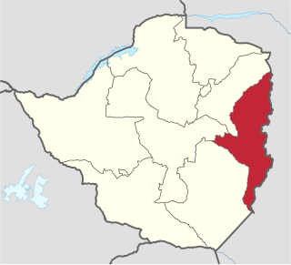
Mutare District is a district in Manicaland Province of eastern Zimbabwe. The district headquarters is the city of Mutare.
Mutare District is a district in Manicaland Province of eastern Zimbabwe. The district headquarters is the city of Mutare.
The district has a rural area of 5,523 km², and an urban area of 191 km². It is bounded on the east by Mozambique, on the northeast by Mutasa District, on the northwest by Makoni District, on the southwest by Buhera District, and on the southeast by Chimanimani District.
The city of Mutare is located in the northeastern corner of the district, near the border with Mozambique. Mutare is the largest city in the district, and the fourth-largest city in Zimbabwe. Other towns include Chiadzwa and Odzi.
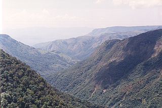
The Eastern Highlands extend north and south through eastern portion of the district, along the border with Mozambique. The Bvumba Mountains form a part of the highlands, and rise southeast of Mutare city. The highest peak is Castle Beacon at 1,911 metres. The Bunga Forest Botanical Reserve conserves the mountains' high-elevation mist forest. Banti Forest Reserve (22.2 km²) is located south of the Bvumba Range, in the mountains along the Mozambican border.
Most of the district lies in the basin of the Save River, which forms the southwestern boundary of the district. The Odzi River, a tributary of the Save, drains the center of the district, flowing southwards to join the Save at the district's southernmost point. The Burma Valley, an area along the southeastern border with Mozambique on the eastern slope of the Bvumba mountains, drains eastwards into the Revué River, a tributary of the Buzi River. [1]
The 2022 census recorded a population of 306,760 in the rural portion of the district. Mutare urban had a population of 224,802. [2]
The rural portion of the district is divided into 36 administrative wards. [3] Mutare has an elected City Council, with 19 councillors each representing one of the city's 19 wards. [4] The city of Mutare is the district's administrative headquarters, and also serves as the administrative headquarters of Manicaland Province.
The district is divided into six Assembly parliamentary constituencies. Dangamvura, Chikanga Mutare Central, Mutare North, Mutare South, and Mutare West constituencies are entirely within the district, and a portion of Mutare municipality is in Mutasa South constituency. The district is divided between two Senate constituencies; Mutare constituency includes Dangamvura-Chikanga, Mutare Central, and Mutare North, while Mutare West and Mutare South are in Chimanimani constituency. [5]
The main east-west road from Harare to the Mozambican port of Beira (R5, or A3 in the older numbering system) runs through Mutare district, crossing the international border just east of Mutare city.
The Beira–Bulawayo railway also passes through Mutare, which has a railway station.
Airports in the district include Mutare Airport, located close to the city, and Grand Reef Airport, located 20 km west of Mutare Airport.
Manicaland is a province in eastern Zimbabwe. After Harare Province, it is the country's second-most populous province, with a population of 2.037 million, as of the 2022 census. After Harare and Bulawayo provinces, it is Zimbabwe's third-most densely populated province. Manicaland was one of five original provinces established in Southern Rhodesia in the early colonial period. The province endowed with country's major tourist attractions, the likes of Mutarazi Falls, Nyanga National Park and Zimbabwe's top three highest peaks. The province is divided into ten administrative subdivisions of seven rural districts and three towns/councils, including the provincial capital, Mutare. The name Manicaland is derived from one of the province's largest ethnic groups, the Manyika, who originate from the area north of the Manicaland province and as well as western Mozambique, who speak a distinct language called ChiManyika in Shona.

Mutare, formerly known as Umtali, is the most populous city in the province of Manicaland, and the third most populous city in Zimbabwe, having surpassed Gweru in the 2012 census, with an urban population of 224,802 and approximately 260,567 in the surrounding districts giving the wider metropolitan area a total population of over 500,000 people. Mutare is also the capital of Manicaland province and the largest city in Eastern Zimbabwe.

The Eastern Highlands, also known as the Manica Highlands, is a mountain range on the border of Zimbabwe and Mozambique. The Eastern Highlands extend north and south for about 300 kilometres (190 mi) through Zimbabwe's Manicaland Province and Mozambique's Manica Province.

The Honde Valley extends from the eastern border of Zimbabwe into Mozambique. The valley is part of the Eastern Highlands. The valley is about 130 kilometres from Mutare, or 110 kilometres from Nyanga. The Nyanga Mountains and the Nyanga National Park forms the western boundary of the valley.

Chimanimani, originally known as Melsetter, is a mountainous district in Manicaland Province of eastern Zimbabwe. The district headquarters is the town of Chimanimani.
Chipinge District is a district in Manicaland Province of Zimbabwe. The administrative headquarters is Chipinge.
The Manyika tribe is a Shona sub-group that originated from Manyika Dynasty. Manyika people spoke several dialects which include ChiManyika, ChiBocha, ChiUngwe, ChiHera, Chijindwi and the Urban dialect which is spoken in urban centers like Mutare and Rusape. The majority of Manyika comes from the eastern region of Zimbabwe and in neighbouring Mozambique. The dialect is widely spoken in Manicaland Province and in certain areas of Manica Province in neighbouring Mozambique. Those from Nyanga, Nyamaropa, Nyatate and surrounding regions speaks ChiManyika variant whereas those from the Buhera and Bocha areas spoke ChiHera and ChiBocha variants. There are inherent cultural norms in each of the sub-regions inhabited by the Manyika.
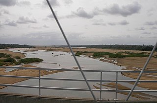
The Save River, or Sabi River is a 400 mi (640 km) river of southeastern Africa, flowing through Zimbabwe and Mozambique. The river has its source in Zimbabwe, some 80 km (50 mi) south of Harare, then flows south and then east, from the Zimbabwean highveld to its confluence with the Odzi River. It then turns south, drops over the Chivirira Falls, and flows down the western side of Zimbabwe's Eastern Highlands forming a dry river valley in the rain shadow of these mountains. It is joined by the Runde River or Lundi at the Mozambique border, forming a dramatic confluence at Mahenya. It then crosses Mozambique to flow into the Indian Ocean at about 21°S.
Buhera District is a district in Manicaland Province, Zimbabwe.
Hauna is a village in the province of Manicaland, Zimbabwe located in the Honde Valley communal land about 55 km north of Mutare.It is the Growth Point Centre for Mutasa District in Manicaland. Hauna growth point is in Samanga B ward of Mutasa District and has a population of about 8,000. There is an aerodrome where small aeroplanes can land and take off. There is also a Police camp called Ruda Police Station which controls all police activities in Mutasa District.

Chisumbanje is an area in the province of Manicaland in Zimbabwe. It is situated in Chipinge District, one of seven districts in the province. It is located in Dowoyo communal land on the eastern bank of the Save River, about 95 km (59 mi) south of Birchenough Bridge on the Birchenough Bridge-Chiredzi road.

The Bvumba Mountains or Vumba Mountains straddle the Zimbabwe–Mozambique border, and are situated some 10 km south east of Mutare. The Bvumba rise to Castle Beacon at 1,911 metres, and are, together with the Chimanimani Mountains to the south and Nyanga Mountains to the north, part of the Eastern Highlands of the Manicaland and adjacent Manica provinces. They are referred to as the "Mountains of the Mist", as so often the early morning starts with a mist which clears by mid-morning. Although lying mostly within Zimbabwe, the mountains extend north-eastward to Mount Vumba in Mozambique. They are capped by cool, green hills which shelter country hotels, a casino and golf course at the Leopard Rock Hotel and a Botanical Garden with one of the best views in Africa. The mountains are also known for their coffee plantations.
Pungwe River is a 400 km (250 mi) long river in Zimbabwe and Mozambique. It rises below Mount Nyangani in the Eastern Highlands of Zimbabwe and then flows southeasteastward through the Manica and Sofala provinces of Mozambique. The Pungwe enters the Urema Valley, the southernmost portion of the Great Rift Valley, where it forms the southern boundary of Gorongosa National Park. The Urema River joins it, and the river follows the rift valley southward. Large seasonal wetlands form around the Pungwe and Urema rivers in the rift valley section. It empties into the Mozambique Channel at Beira, forming a large estuary. It is one of the major rivers of Mozambique and often causes floods.

Chimanimani, originally known as Melsetter, is a town in Zimbabwe.
Mutasa District is one of seven districts in Manicaland Province of Zimbabwe. Mutasa District is located 30 km northeast Mutare and stretches up to the Honde Valley, which is about 100 km northeast of Mutare along a tarred road that branches off the Nyanga road.
Nyanga District is located in Manicaland Province of Zimbabwe.
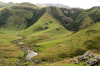
The Chimanimani Mountains are a mountain range on the border of Zimbabwe and Mozambique. The mountains are in the southern portion of the Eastern Highlands, or Manica Highlands, a belt of highlands that extend north and south along the international border, between the Zambezi and Save rivers.
Chimanimani National Park is a protected area in Manica Province of Mozambique. It is located in the Chimanimani Mountains on the border with Zimbabwe. Together with Zimbabwe's Chimanimani National Park it forms the Chimanimani Transfrontier Park. It was designated a national reserve in 2003. In 2020 it was designated a national park.