Related Research Articles
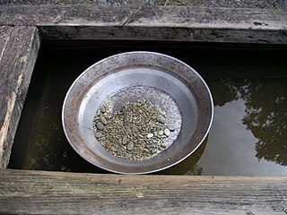
Gold prospecting is the act of searching for new gold deposits. Methods used vary with the type of deposit sought and the resources of the prospector. Although traditionally a commercial activity, in some developed countries placer gold prospecting has also become a popular outdoor recreation. Gold prospecting has been popular since antiquity. From the earliest textual and archaeological references, gold prospecting was a common thread for gaining wealth.
Musina, also known as Messina, is the northernmost town in the Limpopo province of South Africa. It is located near the confluence of the Limpopo River with the Sand River and the border to Zimbabwe with a population of between 20,000 and 40,000. Iron ore, coal, magnetite, graphite, asbestos, diamonds, semi-precious stones and copper are mined in the region.

Tarkwa is a town and is the capital of Tarkwa-Nsuaem Municipal district, a district in the Western Region southwest of South Ghana. Tarkwa has a population of 34,941 people according to 2013 settlement.
The Bangweulu Block is a cratonic unit that forms part of the Congo craton of central Africa. The Bangweulu Block however consists of Palaeoproterozoic granitoids and volcanics, and is overlain by a Palaeoproterozoic continental sedimentary succession, the Mporokoso Group, and does not preserve much direct evidence of Archaean protoliths.
The Mporokoso Group is the name given to a sedimentary succession of fluvial, lacustrine and aeolian sandstones and minor siltstones occurring on the Bangweulu Block of northern Zambia.
Shurugwi, originally known as Selukwe, is a small town and administrative centre in Midlands Province, southern Zimbabwe, located about 350 km south of Harare, with a population of 22,900 according to the 2022 census. The town was established in 1899 on the Selukwe Goldfield, which itself was discovered in the early 1890s not long after the annexation of Rhodesia by the Pioneer Column.

The Homestake Mine was a deep underground gold mine located in Lead, South Dakota. Until it closed in 2002 it was the largest and deepest gold mine in North America. The mine produced more than forty million troy ounces of gold during its lifetime. This is about 2,500 cubic feet (71 m3) or a volume of gold roughly equal to 18,677 US gallons.
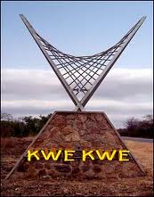
Kwekwe, formerly known as Que Que, is a city in the Midlands province in central Zimbabwe. The city has a population of 119,863 within the city limits, as of the 2022 census, making it the 7th-largest city in Zimbabwe and the second-most populous city in the Midlands, behind Gweru.
Madziwa Mine is a village that grew up next to a gold mine of the same name in the province of Mashonaland Central, Zimbabwe. It is located 32 km north of Shamva and about 100 km north-west of Harare. According to the 1982 Population Census, the village had a population of 4,617. The main mineral mined at Madziwa is nickel.

Shamva is a town in the province of Mashonaland Central in the Shamva District of Zimbabwe. It is located in the Mazowe valley about 90 km north-east of Harare. The area was called Abercorn by Rhodesian colonizers. The present name is derived from a Shona word which means 'to become friendly'. The town is most famous for the gold mine of the same name at the foot of the Shamva Mountain. Nickel is now mined in area after a large nickel deposit was discovered in the area. The gold mine recently reopened after Landela Mining Ventures Ltd., a subsidiary of the Mauritius-based company Sotic International Ltd., purchased the Shamva gold mine from Metallon Corporation, with a goal of producing 400 kg of gold per month by 2023. However attacks, killings, and disappearances of gold miners have been ongoing in various parts of Zimbabwe since 2018, including in Shamva and nearby Mazowe.
Mvuma, previously named 'Umvuma', is a small mining town in Midlands province in Zimbabwe.

In the United States, gold mining has taken place continually since the discovery of gold at the Reed farm in North Carolina in 1799. The first documented occurrence of gold was in Virginia in 1782. Some minor gold production took place in North Carolina as early as 1793, but created no excitement. The discovery on the Reed farm in 1799 which was identified as gold in 1802 and subsequently mined marked the first commercial production.
Silobela is an agricultural village in Kwekwe District in the Midlands Province of Zimbabwe. It is located about 60 kilometres (37 mi) west of Kwekwe town, 80 kilometres (50 mi) north-west of Gweru town, and bordering Nkayi on the west.

Jardine is an unincorporated village in Park County, Montana, United States. The town lies just to the north of Gardiner on inactive travertine terraces, much like those at Mammoth Hot Springs in nearby Yellowstone National Park. The town's chief industry was a gold mine. The community has the name of A. C. Jardine, a businessperson in the mining industry.
Chegutu, originally known as Hartley, is a district of Mashonaland West Province, Zimbabwe. The district headquarters is located in Chegutu, a city which lies of the Harare-Bulawayo Road,.

The geology of Zimbabwe in southern Africa is centered on the Zimbabwe Craton, a core of Archean basement composed in the main of granitoids, schist and gneisses. It also incorporates greenstone belts comprising mafic, ultramafic and felsic volcanics which are associated with epiclastic sediments and iron formations. The craton is overlain in the north, northwest and east by Proterozoic and Phanerozoic sedimentary basins whilst to the northwest are the rocks of the Magondi Supergroup. Northwards is the Zambezi Belt and to the east the Mozambique Belt. South of the Zimbabwe Craton is the Kaapvaal Craton separated from it by the Limpopo Mobile Belt, a zone of deformation and metamorphism reflecting geological events from Archean to Mesoproterozoic times. The Zimbabwe Craton is intruded by an elongate ultramafic/mafic igneous complex known as the Great Dyke which runs for more than 500 km along a SSW/NNE oriented graben. It consists of peridotites, pyroxenites, norites and bands of chromitite.
Commoner, Zimbabwe is a populated place and a place where highly deformed and folded quartz reef structure gold ore is extracted. It is about 50 km west-southwest of Kadoma by air and 68 km by road. It is 67 km north-west of Kwekwe by air and 96 km by road. It is in Zhombe Kwekwe District, Midlands Province, Zimbabwe. Commoner is not to be confused with Commoner Gold Mine near Kadoma in Mashonaland West Province.
The Gaika Mine, now known as the Gaika Gold Fields, is situated in what was Chicago Farm just about 2 kilometres (1.2 mi) south of Kwekwe CBD. The Gaika Mine was the earliest mine developed in 1894, then Globe and Phoenix in 1895-1900, the Eldorado in 1905, the Antelope in 1908, the Cam and Motor Mine in 1909, the Shamva Mine in 1909-1910, and numerous others during the period 1895-1911.
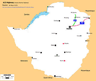
A13 Highway is a busy road in Zimbabwe running from Enterprise Road, Harare to Shamva, Madziwa Mine and through to Gora Turn-off on the A11 Highway towards Wimbo Shrine, Mt Darwin.

The geology of Ghana is primarily very ancient crystalline basement rock, volcanic belts and sedimentary basins, affected by periods of igneous activity and two major orogeny mountain building events. Aside from modern sediments and some rocks formed within the past 541 million years of the Phanerozoic Eon, along the coast, many of the rocks in Ghana formed close to one billion years ago or older leading to five different types of gold deposit formation, which gave the region its former name Gold Coast.
References
- ↑ "Shamva District". GeoNameId : 881344. geonames.org. Retrieved 15 June 2009.
- ↑ Foster, R.P; Wilson, J.F. (1984). Foster, R.P. (ed.). Geological setting of Archaen gold deposits in Zimbabwe, in Gold '82: The Geology, Geochemistry and Genesis of Gold Deposits. Rotterdam: Geological Society of Zimbabwe, A.A. Balkema. pp. 536–539. ISBN 906191504X.
| International | |
|---|---|
| National | |
| | This Zimbabwe location article is a stub. You can help Wikipedia by expanding it. |