
Manicaland is a province in eastern Zimbabwe. After Harare Province, it is the country's second-most populous province, with a population of 2.037 million, as of the 2022 census. Making it the third most densely populated province after Harare and Bulawayo provinces. Manicaland was one of five original provinces established in Southern Rhodesia in the early colonial period. The province endowed with country's major tourist attractions, the likes of Mutarazi Falls, Nyanga National Park and Zimbabwe's top three highest peaks. The province is divided into ten administrative subdivisions of seven rural districts and three towns/councils, including the provincial capital, Mutare. The name Manicaland is derived from one of the province's largest ethnic groups, the Manyika, who originate from the area north of the Manicaland province and as well as western Mozambique, who speak a distinct language called ChiManyika in Shona.

Nyanga, originally known as Inyanga, is a town in Zimbabwe.
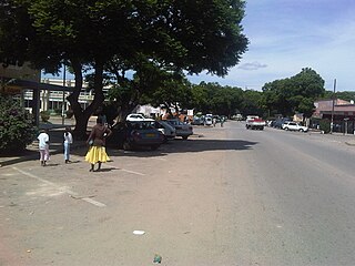
Rusape is a town in eastern Zimbabwe.
The Manyika people are a Shona sub-group that originated from the Manyika Dynasty. Manyika people speak several dialects which include ChiManyika, ChiBocha, ChiUngwe, ChiHera, Chijindwi and the Urban dialect which is spoken in urban centers like Mutare and Rusape.
Headlands is a township in the province of Manicaland, Zimbabwe, on the main Harare-Mutare road about 136 km (85 mi) from Harare. A trading post and tobacco farming area, it was established in 1891 by white settlers. Originally named Laurencedale after the settlers' leader, Laurence van der Byl, the township's name was changed to Headlands in 1897. By 1898 the railway arrived. Copper was discovered about 34 km (21 mi) away in 1908. Inyati Mine is in the district Headlands.
Nyazura is the second largest urban settlement in Makoni District in Manicaland Province, Zimbabwe located 72 km north-west of Mutare on the main road and railway linking Harare and Mutare. The settlement is named after the Nyazure River which is a tributary of the Save River. The phosphate from Dorowa are handled by the railways here. The town is located 191km from Harare along the Harare Mutare Highway. It is 20 kilometres from Rusape and 70km from Mutare. The major part of Nyazura is believed to be under the rule of the Rukweza family.
Tsanzaguru is a township, commuter zone, in the province of Manicaland, Zimbabwe located 10 km south of Rusape in the Makoni West constituency. It is situated by the riverside overlying the Rusape Dam. Named after the kopje, Tsanzaguru, in the overlying village area of Headman Dzvairo, who is under Chief Makoni. The township is under Rusape Town Council and almost three quarters of the small employed population are employed by government either in the army, education or other government enterprises.

The Republic of Zimbabwe is broken down into 10 administrative provinces, which are divided into 64 districts and 1,970 wards.
Lion's Den is a small town in Zimbabwe.

Kadoma, formerly known as Gatooma, is a town in Zimbabwe.
Karoi is a town in Zimbabwe.
Chinhoyi, previously known as Sinoia during the colonial era, is a city in central northern Zimbabwe in the Makonde District. It has a population of 90,800 and is primarily a college town, although it was originally founded as an Italian group settlement scheme. The nearby Chinhoyi Caves and national park are a popular attraction.

Kwekwe, originally known as Que Que, is a district in Zimbabwe. 197,062 people live in Kwekwe rural and 119,863 live in Kwekwe town.

Chimanimani, originally known as Melsetter, is a town in Zimbabwe.

Kadoma District was a district in Zimbabwe. It was splited 2007 in Mhondoro–Ngezi District and Sanyati District.
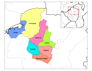
Karoi District is a district of Mashonaland West Province, Zimbabwe. The district is also known as Hurungwe District which extends to Zambian border. The Hurungwe district office are found in Karoi town.
Zvimba District is a district of Mashonaland West Province, Zimbabwe.
Makonde District is a district in Zimbabwe.

R5 Highway is a 270.8 kilometres (168.3 mi) regional road corridor running from Harare to Mutare. It is also known as the A3 Highway. It is part of the Beira–Lobito Highway.
Christopher Peter Mutekwatekwa Chingosho is a Zimbabwean politician who is currently a member of the National Assembly of Zimbabwe for Headlands since 2015. He also served as deputy minister of local government and housing from 2017 to 2018. Previously, he worked in several government ministries and as a district and provincial administrator. He is a member of ZANU–PF, having joined the party in Mozambique during the Rhodesian Bush War in 1975.
