
Bubi is a district in Matabeleland North in Zimbabwe. It is rich in minerals, but lacks infrastructure. [1] Its 2012 census population was 61,883; [2] and had grown to 74,084 by 2022. [3]
Bubi is a district in Matabeleland North in Zimbabwe. It is rich in minerals, but lacks infrastructure. [1] Its 2012 census population was 61,883; [2] and had grown to 74,084 by 2022. [3]
19°30′S28°45′E / 19.500°S 28.750°E
| | This Zimbabwe location article is a stub. You can help Wikipedia by expanding it. |

Zimbabwe, officially the Republic of Zimbabwe, is a landlocked country in Southern Africa, between the Zambezi and Limpopo Rivers, bordered by South Africa to the south, Botswana to the southwest, Zambia to the north, and Mozambique to the east. The capital and largest city is Harare, and the second largest is Bulawayo.

Bulawayo is the second largest city in Zimbabwe, and the largest city in the country's Matabeleland region. The city's population is disputed; the 2022 census listed it at 665,940, while the Bulawayo City Council claimed it to be about 1.2 million. Bulawayo covers an area of about 546 square kilometres in the western part of the country, along the Matsheumhlope River. Along with the capital Harare, Bulawayo is one of two cities in Zimbabwe that is also a province.
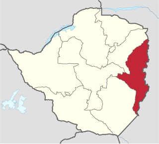
Manicaland is a province in eastern Zimbabwe. After Harare Province, it is the country's second-most populous province, with a population of 2.037 million, as of the 2022 census. After Harare and Bulawayo provinces, it is Zimbabwe's third-most densely populated province. Manicaland was one of five original provinces established in Southern Rhodesia in the early colonial period. The province endowed with country's major tourist attractions, the likes of Mutarazi Falls, Nyanga National Park and Zimbabwe's top three highest peaks. The province is divided into ten administrative subdivisions of seven rural districts and three towns/councils, including the provincial capital, Mutare. The name Manicaland is derived from one of the province's largest ethnic groups, the Manyika, who originate from the area north of the Manicaland province and as well as western Mozambique, who speak a distinct language called ChiManyika in Shona.

Matabeleland North is a province in western Zimbabwe. With a population of 749,017 as of the 2012 census, it is the country's second-least populous province, after Matabeleland South, and is the country's least densely populated province. Matabeleland North was established in 1974, when the original Matabeleland Province was divided into two provinces, the other being Matabeleland South. In 1997, the province lost territory when the city of Bulawayo became its own province. Matabeleland North is divided into seven districts. Its capital is Lupane, and Victoria Falls and Hwange are its largest towns. The name "Matabeleland" is derived from the Matabele or Ndebele people, the province's largest ethnic group.

Matabeleland South is a province in southwestern Zimbabwe. With a population of 683,893 as of the 2012 Zimbabwean census, it is the country's least populous province. After Matabeleland North, it is Zimbabwe's second-least densely populated province. Matabeleland South was established in 1974, when the original Matabeleland Province was divided into two provinces, the other being Matabeleland North. The province is divided into six districts. Gwanda is the capital, and Beitbridge is the province's largest town. The name "Matabeleland" is derived from Ndebele, the province's largest ethnic group.
Esigodini, originally known as Essexvale, is a town in the Matabeleland South Province of Zimbabwe. It is the administrative centre for Umzingwane District, one of the seven administrative districts in Matabeleland South. It was originally an estate of Frederick Selous.
Eastnor is a village in Bubi District, Matabeleland North, Zimbabwe and is located about 125 km northeast of Bulawayo in a commercial farming and gold mining area. It lies next to the Umguemembe, and is within the Bubi Mining District. The mining EPOs/leases were owned by Duration Gold in the south, BilboesGold in the north and Metallon Group in the center. Motapa Mine is immediately adjacent to the village, to the northeast. Bilboes Mine and Motapa Mine were sold to Caledonia Mining Corporation in 2022.
Lonely Mine is a village in Matabeleland North, Zimbabwe and is located about 84 kilometres (52 mi) north-east of Bulawayo, just north of Inyati. It was established in 1906 when gold was discovered in the area. Gold, nickel and tungsten are still mined in the area today.
Plumtree is a town in Zimbabwe. Marula trees, wild plum trees grow abundantly in the area. The town was once called Getjenge by baKalanga. Another name by which it is often caled, is Titji, meaning station and referring to the railway station which was operating in the area around 1897.

Lupane ( luːpɑːnɛ) District is located in the Matabeleland North Province of Zimbabwe, and it is also the Provincial Capital. The District is situated at an elevation of 976 m with a population of 198,600 inhabitants by 2019. Lupane Town is the main center of the district located 172 km from Bulawayo along the A8 Victoria Falls Road. The Government Provincial Administrative offices are located at the Town Centre. A new university near the Town has been established under the name Lupane State University, which caters for the region and beyond. The word Lupane is thought to be a Kalanga or Lozwi word.
Paul Chimedza is the President of the Zimbabwe Medical Association and a politician. Chimedza was born on 29 June 1967 in Masvingo Province, Zimbabwe.
Umguza is a district in the southern part of Matabeleland North province in Zimbabwe. It was formerly known as Esiphezini District.

Inyathi High School is a boarding co-educational secondary school in Inyathi, Zimbabwe. It was established in 1889, making it the oldest formal educational institution in Zimbabwe. Along with Dombodema High School in Plumtree and Tennyson Hlabangane High School in Bulawayo, Inyathi High School is privately owned by the United Congregational Church of Southern Africa (UCCSA) which is itself an offshoot of the London Missionary Society (LMS).
Hwange District is an administrative district in northwestern Zimbabwe, in southern Africa.


Umzingwane is a district in the northern part of Matabeleland South province in Zimbabwe. It was formerly known as Esigodini and before 1982 as Essexvale.
Bulilima District is a district of the Province Matabeleland South in Zimbabwe.
Mangwe District is a district of the Province Matabeleland South in Zimbabwe. It is divided into 17 wards. Some of the wards are Ngwizi, Mphoengs, Sanzukwi, Sangulube, Maninji, Madabe, Mbakwe, Empandeni, Mayobodo, Mambale, Makorokoro, Tshitshi, and Marula. Some villages found in this district are Bulu, Kweneng, Togotsweu. Mangwe used to be a part of bigger district which was known as Bulilimamangwe. Bulilimamangwe was then divided into 3 districts now known as Mangwe, Bulilima and Plumtree.
Matobo, originally Matopos, is a district of the Province Matabeleland South in Zimbabwe.