Chinhoyi

Last updated

Chinhoyi
Sinoia
City
Coat of arms of Chinhoyi.svg
Zimbabwe adm location map.svg
Red pog.svg
Chinhoyi
Coordinates: 17°20′59″S30°11′40″E / 17.34972°S 30.19444°E / -17.34972; 30.19444
Country Zimbabwe
Province Mashonaland West
District Makonde District
CityChinhoyi Municipality
Established1906
Elevation
1,187 m (3,894 ft)
Population
 (2022 census) [1]
  Total90,800
Time zone UTC+2 (CAT)
Climate Cwa

Chinhoyi, previously known as Sinoia during the colonial era, is a city in central northern Zimbabwe in the Makonde District. [2] It has a population of 90,800 and is primarily a college town, although it was originally founded as an Italian group settlement scheme. The nearby Chinhoyi Caves and national park are a popular attraction.

Contents

Geography

Chinhoyi is located on the western banks of the Manyame River, in Makonde District, in Mashonaland West Province in central northern Zimbabwe. Its location lies approximately 116 kilometres (72 mi) northwest of Harare by road, the capital of Zimbabwe and the largest city in the country. [3] Chinhoyi lies on the main road, Highway A-1, between Harare and Chirundu, at the International border with Zambia, about 240 kilometres (150 mi), further northwest of Chinhoyi. [4]

The geographical coordinates of Chinhoyi are:17°20'59.0"S, 30°11'40.0"E (Latitude:-17.349722; Longitude:30.194444). [5] Chinhoyi sits at an average elevation of 1,187 metres (3,894 ft) above mean sea level. [6]

There are a number of small towns which are close to Chinhoyi. Banket lies about 25 kilometres (16 mi), southeast of Chinhoyi on the road to Harare, while Alaska lies approximately 15 kilometres (9 mi) directly west of town, and Lion's Den lies about 25 kilometres (16 mi) northwest of Chinhoyi on the road to Chirundu. [7]

Overview

Chinhoyi is the provincial capital of Mashonaland West Province, one of the ten administrative provinces in Zimbabwe. It is also the district headquarters of Makonde District, one of the six districts in the province. [8]

This is a college town, hosting two of the country's major universities; Chinhoyi University of Technology (CUT) and Zimbabwe Open University (ZOU). The principal secondary schools in Chinhoyi include the three government high schools; Chinhoyi High School, Chemagamba High School and Nemakonde High School, together with the private high school Lomagundi College. [9]

Chinhoyi houses Chinhoyi Provincial Hospital, the largest and most modern referral hospital in Mashonaland West Province. Some of the hotels in town include Chinhoyi Hotel in the center, the Orange Grove Motel about 1 kilometre (1 mi) northwest of town on the road to Karoi and the Caves Motel, located about 8 kilometres (5 mi) northwest of town next to the Chinhoyi caves. Tourist attractions in Chinhoyi include the Chinhoyi Caves in Chinhoyi Caves National Park. [10]

History

The town was established as Sinoia in 1906, as a group settlement scheme by a wealthy Italian, Lieutenant Margherito Guidotti. He encouraged ten Italian families to settle here. The Rhodesian Bush War started in this town in the area occupied by the Chinhoyi Provincial Hospital. The name Sinoria derives from Tjinoyi, a Lozwi/Rozwi Chief who is believed to have been a son of Lukuluba (corrupted to Mukuruva by the Zezuru), who was the third son of Emperor Netjasike. The Kalanga (Lozwi/Rozwi name) was changed to Sinoia by the white settlers and later Chinhoyi by the Zezuru. [2]

Transport

Transport to and from Chinhoyi is mainly by road. Bus services connect Chinhoyi with Harare, Karoi, Kariba, Mhangura, Bulawayo, and smaller villages in the district. Chinhoyi is on a rail branch from Harare, which ends at Lions Den. There are scheduled passenger trains. Taxis operate within the town area. There is also a local bus service. There is a small airport for private planes, called Chinhoyi Airstrip, located about 16 kilometres (10 mi), south-east of the central business district. The airport is said to be in need of maintenance. Its geographical coordinates are quoted as:17°25'58.8"S, 30°18'00.0"E (Latitude:-17.433000; Longitude:30.300000). [11] [12]

Economy

Chinhoyi's economy is a tertiary industry meaning that it is mainly a service industry based economy. It consists of retailing, financial services, wholesaling, and provincial government services since the city is the provincial capital. Education and the construction industry influence the economy of the city. The presence of Chinhoyi University of Technology and the construction of new houses contribute to the town's economy. The city also provides many services to the surrounding small towns like Banket, Kasimure, Mutorashanga, as well as to the whole of the Makonde district.

Financial services

First Capital Bank Zimbabwe Limited, a commercial bank, maintains a branch in the town. ZB Bank Limited, sometimes referred to as Zimbank, another commercial bank, also has a branch in Chinhoyi. CBZ Bank Limited is also another bank with a branch in Chinhoyi. [13] There are also BancABC, NMB bank NBS bank, CABS, Agribank and Steward bank agents.

Population

The population of Chinhoyi during the 2002 census was 56,794. After the 2012 national census, the city population was estimated at 77,292 people. At that time it was the 11th largest urban centre in Zimbabwe. [14]

Recreational sites

Chinhoyi Caves

Sleeping Pool, Chinhoyi caves Sleeping Pool, Chinhoyi caves, Zimbabwe.JPG
Sleeping Pool, Chinhoyi caves

These are a group of limestone and dolomite caves situated about 9 kilometers northwest of Chinhoyi along the A-1 Highway. The main cave contains a pool of cobalt blue water, which is popularly called Sleeping Pool or Chirorodziva ("Pool of the Fallen"). [15] They have been designated as a national park and they are managed by the Zimbabwe Parks & Wildlife Management Authority. [10] These limestone caves were first described to Europeans by Frederick Courtney Selous in 1887, but the caves have an important place in African traditional religion, with the caves themselves as a site for rainmaking, surrounded by a sacred forest, whose trees could not be felled. [16]

See also

Related Research Articles

<span class="mw-page-title-main">Manicaland Province</span> Province in Zimbabwe

Manicaland is a province in eastern Zimbabwe. After Harare Province, it is the country's second-most populous province, with a population of 2.037 million, as of the 2022 census. Making it the third most densely populated province after Harare and Bulawayo provinces. Manicaland was one of five original provinces established in Southern Rhodesia in the early colonial period. The province endowed with country's major tourist attractions, the likes of Mutarazi Falls, Nyanga National Park and Zimbabwe's top three highest peaks. The province is divided into ten administrative subdivisions of seven rural districts and three towns/councils, including the provincial capital, Mutare. The name Manicaland is derived from one of the province's largest ethnic groups, the Manyika, who originate from the area north of the Manicaland province and as well as western Mozambique, who speak a distinct language called ChiManyika in Shona.

<span class="mw-page-title-main">Chinhoyi Caves</span> Group of caves in north central Zimbabwe

The Chinhoyi Caves are a group of limestone and dolomite caves in north central Zimbabwe. Designated a National Park in 1955, and managed by the Zimbabwe Parks & Wildlife Management Authority.

Alaska is a small town in central northern Zimbabwe in Makonde District, Mashonaland West Province.

Banket is a town in the province of Mashonaland West, Zimbabwe. It is located about 95 km north-west of Harare on the main Harare-Chinhoyi road. According to the 1982 Population Census, the town had a population of 5,698. The name of the town is derived from banket rock formation: early settlers saw a conglomerate, which they hoped would bear gold, like the banket of the Witwatersrand gold fields. The conglomerate was not gold-bearing, although gold was late discovered and, along with chromite, is still mined in the area. Cattle, maize, cotton and tobacco are commercially farmed in the area.

Sanyati is a town in Zimbabwe.

Lion's Den is a small town in Zimbabwe.

Karoi is a town in Zimbabwe.

<span class="mw-page-title-main">Mwami, Zimbabwe</span> Settlement in Zimbabwe

Mwami is a settlement in the province of Mashonaland West, Zimbabwe.

<span class="mw-page-title-main">Lomagundi College</span> Independent, boarding and day school in Chinhoyi, Mashonaland West, Zimbabwe

Lomagundi College is an independent, co-educational, boarding and day, senior school in Zimbabwe which is situated about 130 km northwest of the capital Harare along the Harare-Chirundu highway on the outskirts of Chinhoyi the provincial capital of Mashonaland West.

Murombedzi is a town in Zimbabwe.
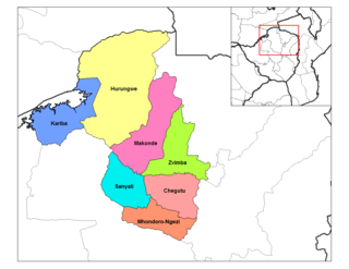
<span class="mw-page-title-main">Karoi District</span> Place in Mashonaland West, Zimbabwe

Karoi District is a district of Mashonaland West Province, Zimbabwe. The district is also known as Hurungwe District which extends to Zambian border. The Hurungwe district office are found in Karoi town.

<span class="mw-page-title-main">Zvimba District</span> Place in Mashonaland West, Zimbabwe

Zvimba District is a district of Mashonaland West Province, Zimbabwe.

<span class="mw-page-title-main">Makonde District</span> District in Zimbabwe

Makonde District is a district in Zimbabwe.

The Battle of Sinoia, also known as the Battle of Chinhoyi was a small military engagement fought near Sinoia between a small unit of Zimbabwe African National Liberation Army (ZANLA) guerrillas and the Rhodesian police force on 28 April 1966. The skirmish is generally considered the opening engagement of the Rhodesian Bush War A team of seven ZANLA cadres engaged with British South Africa Police forces near the northern town of Sinoia. The seven guerrillas all eventually died in the battle, the police killing all seven.

The R3 highway is a primary road in Zimbabwe that runs from the capital city, Harare, to the Chirundu Border Post with Zambia. It is also known as the A1 highway. It is part of both the Beira–Lobito Highway and the Cape to Cairo Road.

<span class="mw-page-title-main">Chirundu–Beitbridge Regional Road Corridor</span> Route in Zimbabwe

Chirundu–Beitbridge Road Corridor is a Trans-African Highway Network Zimbabwean link between South Africa and Zambia. It is part of the North–South Corridor Project and forms the entire Zimbabwean section of the Cape to Cairo Road.

The P12 Makuti-Kariba Highway is a 2-way asphalt surface international highway from the A1 Highway at Makuti to Zambia via the Kariba Dam Wall. The maximum speed on this road is 120 kilometres (75 mi) per hour. It is part of Zimbabwean trunk road system.

<span class="mw-page-title-main">A12 road (Zimbabwe)</span> Road in Zimbabwe

The A12 is a road in Zimbabwe running from the A11 just past Mazowe, just over 30 km from Harare, to Centenary about 145 km from Harare.

Italian Zimbabweans are citizens or residents of Zimbabwe of Italian heritage. The phrase may refer to someone born in the Zimbabwe of Italian descent, someone who has emigrated from Italy to Zimbabwe, a person with Italo-Zimbabwean heritage or someone born elsewhere, who is of Italian descent and has migrated to Zimbabwe. Italian Zimbabweans form one of the younger communities of the Italian diaspora, largely a product of wartime and post-war immigration.

References

  1. Citypopulation.de Population of cities & urban localities in Zimbabwe
  2. 1 2 Parliament of Zimbabwe (3 December 2013). "Names Alteration Act 10/14: Part II: Municipalities And Municipal Councils: Old–Municipality of Sinoia; New–Municipality of Chinhoyi" (PDF). Harare: Parliament of Zimbabwe. Archived from the original (Archived from the original on 3 December 2013) on 3 December 2013. Retrieved 25 May 2020.
  3. "Road Distance Between Chinhoyi, Zimbabwe And Harare, Zimbabwe" (Map). Google Maps . Retrieved 25 May 2020.
  4. "Road Distance Between Chinhoyi, Zimbabwe And Chirundu, Zambia" (Map). Google Maps . Retrieved 25 May 2020.
  5. "Location of Chinhoyi, Zimbabwe" (Map). Google Maps . Retrieved 25 May 2020.
  6. Flood Map (25 May 2020). "Elevation of Chinhoyi, Zimbabwe". Floodmap.net. Retrieved 25 May 2020.
  7. "Distance Between Chinhoyi, Zimbabwe And Lions Den, Zimbabwe" (Map). Google Maps . Retrieved 25 May 2020.
  8. Conrad Mupesa (4 April 2020). "Chinhoyi isolation centre needs US$1 million". The Zimbabwe Herald . Harare. Retrieved 25 May 2020.
  9. Scotty Photography (1 August 2017). "About Lomagundi College". Scottyphotography.net. Retrieved 25 May 2020.
  10. 1 2 Zimparks (25 May 2020). "Overview of Chinhoyi Caves Recreational Park". Harare: Zimbabwe Parks and Wildlife Management Authority (Zimparks). Archived from the original on 31 May 2019. Retrieved 25 May 2020.
  11. Maps.me (25 May 2020). "The Airport Strip at Zimbabwe, Mashonalandia Occidental, Chinhoyi". Maps.me. Retrieved 25 May 2020.
  12. "Location of Chinhoyi Airstrip" (Map). Google Maps . Retrieved 25 May 2020.
  13. The Zimbabwe Herald (13 November 2007). "Zimbabwe: CBZ Opens Branch in Chinhoyi" (via AllAfrica.com). The Zimbabwe Herald . Harare. Retrieved 25 May 2020.
  14. Wolfram Alpha. "Population of Chinhoyi, Zimbabwe". Wolframalpha.com. Retrieved 25 May 2020.
  15. Scheffel, Richard L.; Wernet, Susan J., eds. (1980). Natural Wonders of the World. United States of America: Reader's Digest Association, Inc. p. 345. ISBN   0-89577-087-3.
  16. Kwashirai, Vimbai (2010). "Zimbabwe's Chinhoyi Caves: 1845-1945". Global Environment. 3 (5): 71–110. doi:10.3197/ge.2010.030504.