Chinhoyi Caves Recreational Park | |
---|---|
| |
Location | Chinhoyi District, Zimbabwe |
Nearest city | Chinhoyi |
Coordinates | 17°21′0″S30°07′30″E / 17.35000°S 30.12500°E |
Governing body | Zimbabwe Parks and Wildlife Management Authority |
Official name | Chinhoyi Caves Recreational Park |
Designated | 3 May 2013 |
Reference no. | 2103 [1] |
The Chinhoyi Caves (previously the Sinoia Caves) are a group of limestone and dolomite caves in north central Zimbabwe. [2] Designated a National Park in 1955, and managed by the Zimbabwe Parks & Wildlife Management Authority.
The caves are located in Makonde District, Mashonaland West Province, in north central Zimbabwe. They lie approximately 9 kilometres (5.6 mi), by road, northwest of Chinhoyi (formerly Sinoia), the nearest large town, and the location of the district and provincial headquarters. [3] This location lies about 135 kilometres (84 mi), northwest of Harare, the capital. [4] The caves lie on the main road, Highway A-1, between Harare and Chirundu, at the International border with the Republic of Zambia, about 250 kilometres (160 mi), further northwest of the caves. [5]
The cave system is composed of limestone and dolomite. The main cave contains a pool of cobalt blue water, which is popularly called Sleeping Pool or Chirorodziva ("Pool of the Fallen"). [2] Divers have discovered a submarine passage leading from the Bat Cave, a subchamber of the Dark Cave to another room known as the Blind Cave. Diving is possible in the caves all year round, with temperatures never beyond the 22 to 24 °C (72 to 75 °F) range with zero thermocline. Visibility is high, and 50 metres (160 ft) and above is not unusual. This site is often visited by diving expedition teams of technical divers that perform ultra deep diving. It is not uncommon for dives in excess of 100 metres (330 ft) to be made here by experienced technical divers. A campsite, run by the National Parks Authority, and a motel are located on-site.
The local name for the cave's pool, Chirorodziva ("Pool of the Fallen") comes from an incident that occurred in 1830, where members of the Angonni tribe attacked the local people and threw their victims into the cave to dispose of them. [2]
The limestone caves were first described by Frederick Courtney Selous in 1888. These caves are the most extensive cave system in Zimbabwe that the public can access.
The caves have an important place in African Traditional Religion, with the caves themselves as a site for rainmaking, surrounded by a sacred forest, from which trees could not be felled. [6]
Nyanga, originally known as Inyanga, is a town in Zimbabwe.
Alaska is a small town in central northern Zimbabwe in Makonde District, Mashonaland West Province.
Sanyati is a town in Zimbabwe.
Colleen Bawn is a town in Zimbabwe.
Lion's Den is a small town in Zimbabwe.
Karoi is a town in Zimbabwe.
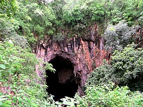
Chinhoyi, previously known as Sinoia during the colonial era, is a city in central northern Zimbabwe in the Makonde District. It has a population of 90,800 and is primarily a college town, although it was originally founded as an Italian group settlement scheme. The nearby Chinhoyi Caves and national park are a popular attraction.
Mwami is a settlement in the province of Mashonaland West, Zimbabwe.
Mount Darwin is a town in Mashonaland Central province in Zimbabwe.
Chimanimani, originally known as Melsetter, is a town in Zimbabwe.
Chipinge, formerly known as Chipinga, is a town in Zimbabwe, located in Chipinge District, in Manicaland Province, in southeastern Zimbabwe, close to the border with Mozambique.
Murombedzi is a town in Zimbabwe.
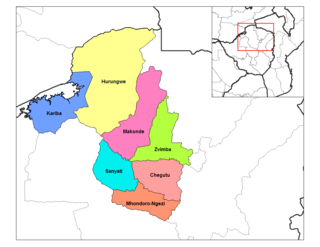
Karoi District is a district of Mashonaland West Province, Zimbabwe. The district is also known as Hurungwe District which extends to Zambian border. The Hurungwe district office are found in Karoi town.
Chegutu, originally known as Hartley, is a district of Mashonaland West Province, Zimbabwe. The district headquarters is located in Chegutu, a city which lies of the Harare-Bulawayo Road,.
Zvimba District is a district of Mashonaland West Province, Zimbabwe.
Makonde District is a district in Zimbabwe.
The A5 Highway is a national road in Zimbabwe. It joins the cities of Harare and Bulawayo, and is hence known as the Harare-Bulawayo Highway. It is one of the two routes that form the R2 Route, which connects Harare with the Plumtree Border with Botswana.
The R3 highway is a primary road in Zimbabwe that runs from the capital city, Harare, to the Chirundu Border Post with Zambia. It is also known as the A1 highway. It is part of both the Beira–Lobito Highway and the Cape to Cairo Road.
Chirundu–Beitbridge Road Corridor is a Trans-African Highway Network Zimbabwean link between South Africa and Zambia. It is part of the North–South Corridor Project and forms the entire Zimbabwean section of the Cape to Cairo Road.
The P12 Makuti-Kariba Highway is a 2-way asphalt surface international highway from the A1 Highway at Makuti to Zambia via the Kariba Dam Wall. The maximum speed on this road is 120 kilometres (75 mi) per hour. It is part of Zimbabwean trunk road system.