
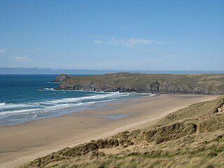
Kennack Sands (Cornish : Porth Keunek) is a beach and sand-dune system on the east coast of the Lizard Peninsula, Cornwall, England, UK. [1]
Kennack Sands (Cornish : Porth Keunek) is a beach and sand-dune system on the east coast of the Lizard Peninsula, Cornwall, England, UK. [1]
The beach is approximately 500 metres (1,600 ft) long and backed by cliffs, Kennack Towans (sand-dune system) and Carn Kennack. Inland is the abandoned Gwendreath Quarry. The beach is used for recreation and divided into two by an outcrop of rocks called the Caerverracks. Kennack Sands has a gently sloping beach so the beach width varies considerably with the tide. There is a rocky outcrop that splits the beach into two so the beach may be referred to as Kennack Sands west and Kennack Sands East. The rock that splits the beaches is called Caerverracks and the hill above this Carn Kennack. There is a path that runs over Carn Kennack allowing access to the east beach which is a designated nature reserve. [2]
It is a popular site for launching inflatables for underwater diving. Less than 400 metres (1,300 ft) off-shore the depth of water is over 16 metres (52 ft). [3]
The nearest village is Kuggar, 1 kilometre (0.62 miles) inland. There is a car park and café on the western side of the beach and on the road to Kuggar there are caravan and camping sites.
Pill boxes and an anti-tank wall were built on the back of the beach in case of invasion during the Second World War. [4] [5]

A dune is a landform composed of wind- or water-driven sand. It typically takes the form of a mound, ridge, or hill. An area with dunes is called a dune system or a dune complex. A large dune complex is called a dune field, while broad, flat regions covered with wind-swept sand or dunes, with little or no vegetation, are called ergs or sand seas. Dunes occur in different shapes and sizes, but most kinds of dunes are longer on the stoss (upflow) side, where the sand is pushed up the dune, and have a shorter slip face in the lee side. The valley or trough between dunes is called a dune slack.

The South West Coast Path is England's longest waymarked long-distance footpath and a National Trail. It stretches for 630 miles (1,014 km), running from Minehead in Somerset, along the coasts of Devon and Cornwall, to Poole Harbour in Dorset. Because it rises and falls with every river mouth, it is also one of the more challenging trails. The total height climbed has been calculated to be 114,931 ft (35,031 m), almost four times the height of Mount Everest. It has been voted 'Britain's Best Walking route' twice in a row by readers of The Ramblers' Walk magazine, and regularly features in lists of the world's best walks.

Perranporth is a seaside resort town on the north coast of Cornwall, England, United Kingdom. It is 2.1 miles east of the St Agnes Heritage Coastline, and around 7 miles south-west of Newquay. Perranporth and its 2 miles (3 km) long beach face the Atlantic Ocean. It has a population of 3,066, and is the largest settlement in the civil parish of Perranzabuloe. It has an electoral ward in its own name whose population was 4,270 in the 2011 census.
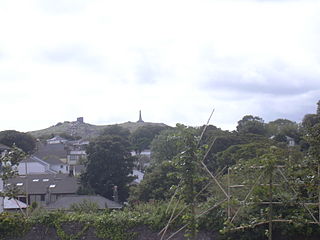
Carn Brea is a civil parish and hilltop site in Cornwall, England, United Kingdom. The population of Carn Brea including Bosleake and Church Coombe was 8,013 at the 2011 census. The hilltop site is situated approximately one mile (1.6 km) southwest of Redruth. The settlements of Bosleake, Brea, Broad Lane, Carn Arthen, Carn Brea Village, Carnkie, Four Lanes, Grillis, Illogan Highway, Pencoys, Penhallick, Piece, Pool, Tolskithy, Tregajorran, Treskillard, Tuckingmill and West Tolgus are in the parish.

Mount's Bay is a bay on the English Channel coast of Cornwall, England, stretching from the Lizard Point to Gwennap Head. In the north of the bay, near Marazion, is St Michael's Mount; the origin of name of the bay. In summer, it is a generally benign natural harbour. However, in winter, onshore gales present maritime risks, particularly for sailing ships. There are more than 150 known wrecks from the nineteenth century in the area. The eastern side of the bay centred around Marazion and St Michael's Mount was designated as a Marine Conservation Zone in January 2016.

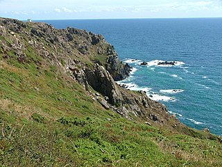
The Manacles are a set of treacherous rocks off The Lizard peninsula in Cornwall. The rocks are rich in marine wildlife and they are a popular spot for diving due to the many shipwrecks. Traditionally pronounced mean-a'klz (1808), the name derives from the Cornish meyn eglos, the top of St Keverne church spire being visible from the area.

The Ythan Estuary is the tidal component of the Ythan River, emptying into the North Sea 19 kilometres (12 mi) north of Aberdeen, Scotland. The estuary’s tidal action extends a 7 kilometres (4.3 mi) inland and has characteristic widths of between 250 metres (820 ft) and 780 metres (2,560 ft). Besides the tidal channel there are interfaces to the upland dunes including mudflats, sand beaches and shingle flats. Reaches of salt marsh occur, but they are primarily near the Waterside Bridge and the mouth of the Tarty Burn, a small tributary river. Based upon the habitat of the moorland bordering the east of the Ythan River near the mouth, this estuary is the most significant coastal moorland in the northern United Kingdom.

Gugh could be described as the sixth inhabited island of the Isles of Scilly, but is usually included with St Agnes with which it is joined by a sandy tombolo known as "The Bar" when exposed at low tide. The island is only about 1 km (0.62 mi) long and about 0.5 km (0.31 mi) wide, with the highest point, Kittern Hill, at 34 m (112 ft). The geology consists of Hercynian granite with shallow podzolic soils on the higher ground and deeper sandy soils on the lower ground. The former Gugh farm is just north of the neck across the middle of the island between the two hills. The two houses were designed and built in the 1920s by Charles Hamlet Cooper.

Perranzabuloe is a coastal civil parish and a hamlet in Cornwall, England, United Kingdom. Perranzabuloe parish is bordered to the west by the Atlantic coast and St Agnes parish, to the north by Cubert parish, to the east by St Newlyn East and St Allen parishes and to the south by Kenwyn parish. The hamlet is situated just over a mile (2 km) south of the principal settlement of the parish, Perranporth; the hamlet is also seven miles (11 km) south-southwest of Newquay. Other settlements in the parish include Perrancoombe, Goonhavern, Mount and Callestick. The parish population was 5,382 in the 2001 census, increasing to 5,486 at the 2011 census.

Towan is found in many placenames in Cornwall. However, The Towans usually refers to the three-mile (5 km) stretch of coastal dunes which extends north-east from the estuary of the River Hayle to Gwithian beach with a midpoint near Upton. The South West Coast Path crosses the towans.

Chapel Carn Brea is an elevated Hercynian granite outcrop, owned by the National Trust at the southern edge of the civil parish of St Just, Cornwall, England, United Kingdom. The hill is 5 kilometres (3.1 mi) south of St Just and 3.5 kilometres (2.2 mi) east of Sennen Cove, and just to the north of the A30 London to Land's End road, which runs through the village of Crows-an-Wra. It should not be confused with another Carn Brea, the hill overlooking the Camborne–Redruth area.

Downderry is a coastal village in south-east Cornwall, England, United Kingdom. It is 12 miles (19 km) west of Plymouth and one mile east of Seaton.

St Ives Bay is a bay on the Atlantic coast of north-west Cornwall, England, United Kingdom. It is in the form of a shallow crescent, some 4 miles or 6 km across, between St Ives in the west and Godrevy Head in the east.

Kuggar is a hamlet in the parish of Grade-Ruan in Cornwall, England. Kuggar, within the Cornwall Area of Outstanding Natural Beauty (AONB), lies off the A3083 road, between the villages of St Ruan and Gwendreath.

Poltesco is a hamlet and valley in the parish of Grade-Ruan, on the Lizard Peninsula, Cornwall, UK. The lower part of the valley is owned by the National Trust and was once the site of a stone industry that exported carved ornaments to the rest of Britain and Europe.

Kelsey Head is a coastal Site of Special Scientific Interest (SSSI) and headland in north Cornwall, England, UK, noted for its biological interest. The site contains an Iron Age hill fort.
Kennack to Coverack is a coastal Site of Special Scientific Interest (SSSI) on the Lizard Peninsula in Cornwall, England, UK, noted for both its biological and geological interest. It is of botanical importance, with 8 Red Data Book of rare and endangered plant species being found on the site as well as other nationally scarce varieties.
Penhale Sands, or Penhale Dunes, is a complex of sand dunes and a protected area for its wildlife, on the north Cornwall coast in England, UK. It is the most extensive system of sand dunes in Cornwall and is believed to be the landing site of Saint Piran. Dating from the 6th century, St Piran's Oratory is thought to be one of the oldest Christian sites in Britain. The remains were discovered in the late 18th century, and in 2014 the covering sand was removed to reveal a building more than a thousand years old, in a reasonable state of preservation. A restricted military area dating from 1939, Penhale Camp, is found on the northern part of the dunes.

Cornish promontory forts, commonly known in Cornwall as cliff castles, are coastal equivalents of the hill forts and Cornish "rounds" found on Cornish hilltops and slopes. Similar coastal forts are found on the north–west European seaboard, in Normandy, Brittany and around the coastlines of the British Isles, especially in Wales, Scotland and Ireland. Many are known in southwest England, particularly in Cornwall and its neighbouring county, Devon. Two have been identified immediately west of Cornwall, in the Isles of Scilly.
50°00′21″N5°09′43″W / 50.005835°N 5.162034°W
| | This Cornwall location article is a stub. You can help Wikipedia by expanding it. |