Panglao, Bohol

Last updated

Panglao
Municipality of Panglao
Church St Augustine Panglao Outside.jpg
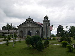
St. Augustine church and watchtower
Ph locator bohol panglao.png
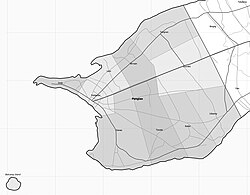
Map of Bohol with Panglao highlighted
OpenStreetMap
Panglao, Bohol
Philippines location map (square).svg
Red pog.svg
Panglao
Location within the Philippines
Coordinates: 9°34′44″N123°44′42″E / 9.579°N 123.745°E / 9.579; 123.745
CountryPhilippines
Region Central Visayas
Province Bohol
District 1st district
Founded 1803
Barangays 10 (see Barangays)
Government
[1]
  Type Sangguniang Bayan
   Mayor Edgardo “Boy” Arcay [2]
   Vice Mayor Noel Hormachuelos [2]
   Representative Edgardo 'Edgar' M. Chatto [3]
   Municipal Council
Members
   Electorate 28,052 voters (2022)
Area
[4]
  Total47.79 km2 (18.45 sq mi)
Elevation
[5]
10 m (30 ft)
Highest elevation
187 m (614 ft)
Lowest elevation
0 m (0 ft)
Population
 (2020 census) [6]
  Total39,839
  Density830/km2 (2,200/sq mi)
   Households
8,694
Economy
   Income class 4th municipal income class
   Poverty incidence
12.60
% (2018) [7]
   Revenue 225 million (2020)
   Assets 798.4 million (2020)
   Expenditure 201.2 million (2020)
   Liabilities 177.7 million (2020)
Service provider
  ElectricityBohol 1 Electric Cooperative (BOHECO 1)
Time zone UTC+8 (PST)
ZIP code
6340
PSGC
IDD : area code +63(0)38
Native languages Boholano dialect
Cebuano
Tagalog
Website www.panglao.gov.ph

Panglao, officially the Municipality of Panglao (Cebuano : Munisipalidad sa Panglao; Tagalog : Bayan ng Panglao), is a 4th class municipality in the province of Bohol, Philippines. According to the 2020 census, it has a population of 39,839 people. [6]

Contents

It is one of two municipalities that make up Panglao Island (the other being Dauis). Panglao is known for its diving locations and tourist resorts. [8]

The name Panglao may have come from its former name Panglawod, meaning "to the open sea", [9] or derived from the word panggaw, referring to a fishing implement used by locals. [10]

Panglao has educational institutions, including the San Agustin Academy (Panglao), Lourdes National High School, the Cristal e-College, and elementary schools located in every barangay (including the Panglao Central Elementary School). It is also home to Bohol–Panglao International Airport that serves as Bohol's primary airport, replacing Tagbilaran Airport in November 2018. [11]

The town of Panglao, Bohol celebrates its fiesta on August 27–28, to honor the town patron San Agustin. [12]

History

Well before the Spanish colonization, the area was already long visited by Chinese and other Asian traders, as evinced by archaeological finds of Tang, Song, and Ming dynasty porcelain and trade wares. [10]

Panglao flourished during the rule of the Dapitan kingdom, but raids by Moluccans and conquest by Ternate resulted in periods of depopulation when its population fled mostly to Panay and Mindanao, including Dapitan. [10]

During the Spanish rule, a Jesuit mission post was established, that in 1782 was formed into a parish, known as La Iglesia de San Agustin de Panglawod. In 1803, the town was officially made into a municipality. [9]

The Panglao watchtower was built in 1851. The 5-storey octagonal tower is the tallest of its kind in the Philippines but suffers from neglect. [9]

Geography

Map of Panglao showing barangays and islands Panglao bw-001.jpg
Map of Panglao showing barangays and islands

The municipality occupies the southwestern part of the eponymous Panglao Island, and its territory also includes the three smaller islands of Balicasag, [13] Gakang, and Pontod (or Pungtud, also known as Virgin Island). [10] It is 20 kilometres (12 mi) from Tagbilaran.

There are no fresh water streams or lakes on the island, so for its drinking water, the municipality is dependent on wells and the Canhilbas Underground Spring. [10]

Climate

Climate data for Panglao, Bohol
JanFebMarAprMayJunJulAugSepOctNovDecYear
Average high°C
°F
30.3
86.5
30.5
86.9
31.4
88.5
32.6
90.7
33.1
91.6
32.5
90.5
32.1
89.8
32.3
90.1
32.1
89.8
31.9
89.4
31.6
88.9
31.0
87.8
31.8
89.2
Average mean°C
°F
26.3
79.3
26.3
79.3
26.9
80.4
27.9
82.2
28.5
83.3
28.1
82.6
27.8
82.0
27.9
82.2
27.7
81.9
27.6
81.7
27.3
81.1
26.9
80.4
27.5
81.5
Average low°C
°F
22.3
72.1
22.2
72.0
22.5
72.5
23.3
73.9
23.9
75.0
23.7
74.7
23.5
74.3
23.6
74.5
23.4
74.1
23.3
73.9
23.1
73.6
22.9
73.2
23.1
73.6
Average rainfall  mm
in
119
4.7
90
3.5
88
3.5
70
2.8
96
3.8
147
5.8
137
5.4
116
4.6
130
5.1
190
7.5
217
8.5
144
5.7
1,544
61
Climate-data.org [14] July 2016Köppen-Geiger climate classification AfCoronas type III

Barangays

Panglao is politically subdivided into 10 barangays. Each barangay consists of puroks and some have sitios.

PSGC Barangay Population ±% p.a. AreaPD2020
2020 [6] 2010 [15] haacre/km2/sq mi
071233001 Bilisan 9.2% 3,649 3,050 1.81% 364899 1,000 2,600 
071233002 Bolod 4.8% 1,906 1,690 1.21% 5981,478 320 830 
071233003 Danao 12.4% 4,935 3,860 2.49% 7901,952 620 1,600 
071233004 Doljo 8.6% 3,417 3,004 1.30% 110272 3,100 8,000 
071233005 Libaong 5.4% 2,132 1,842 1.47% 4231,045 500 1,300 
071233006 Looc 6.4% 2,543 2,282 1.09% 254628 1,000 2,600 
071233007 Lourdes 3.9% 1,544 1,387 1.08% 377932 410 1,100 
071233008 Poblacion 13.3% 5,305 4,831 0.94% 6831,688 780 2,000 
071233009 Tangnan 9.1% 3,645 3,324 0.93% 6291,554 580 1,500 
071233010 Tawala 11.2% 4,477 3,333 2.99% 8922,204 500 1,300 
Total39,83928,6033.37%4,77911,8098302,200
Circle frame.svgPoblacion: 5,305 (15.8%)Danao: 4,935 (14.7%)Tawala: 4,477 (13.3%)Tangnan: 3,645 (10.9%)Bil-isan: 3,649 (10.9%)Doljo: 3,417 (10.2%)Looc: 2,543 (7.6%)Libaong: 2,132 (6.4%)Bolod: 1,906 (5.7%)Lourdes: 1,544 (4.6%)

Demographics

Population census of Panglao
YearPop.±% p.a.
1903 7,050    
1918 9,065+1.69%
1939 9,411+0.18%
1948 11,274+2.03%
1960 11,836+0.41%
1970 13,309+1.18%
1975 13,624+0.47%
1980 14,547+1.32%
1990 17,004+1.57%
1995 18,095+1.17%
2000 21,337+3.60%
2007 25,558+2.52%
2010 28,603+4.18%
2015 33,553+3.09%
2020 39,839+3.43%
Source: Philippine Statistics Authority [16] [15] [17] [18]

Economy

Tourism

The primary tourist attraction of Panglao are its white sandy beaches, of which Alona Beach is the most famous and most developed. Alona Beach is about 1,500 metres (1,640 yd) long, lined with palm trees. resorts, and shops. [26] However it has drawn criticism for its unrestrained development that ignored municipal development policies, warning against overcrowding and Alona to lose its paradise-like image. [27] Therefore, the municipal, provincial and national governments are ploughing ahead with a plan to build a new international airport on Panglao island, with the final approach path directly over Alona beach. Bohol–Panglao International Airport, also known as New Bohol International Airport, is an international airport on Panglao Island in the province of Bohol, Philippines. It replaced Tagbilaran Airport which was small. Bohol–Panglao International Airport, has been operational since 28-Nov-2018.

Other beaches include Bagobo, Bolod, Danao, Doljo, and Momo Beaches there are many more hidden beaches. Some are controlled by various resorts also.

Panglao is renowned for snorkeling and dive sites such as Doljo Beach, Garden Eels, Arco Point, Kalipayan, Napaling, and Puntod. The island's southern portion is ringed with reefs that are relatively narrow and shallow (5 to 6 metres (16 to 20 ft)) with submarine cliffs plunging to depths of 33 to 56 metres (108 to 184 ft). [28] Tours can readily be arranged to further dive sites, including Balicasag and Pamilacan, Bohol islands.

Notable personalities

Related Research Articles

<span class="mw-page-title-main">Padre Burgos, Southern Leyte</span> Municipality in Southern Leyte, Philippines

Padre Burgos, officially the Municipality of Padre Burgos, is a 5th class municipality in the province of Southern Leyte, Philippines. According to the 2020 census, it has a population of 11,159 people.

<span class="mw-page-title-main">Dauin</span> Municipality in Negros Oriental, Philippines

Dauin, officially the Municipality of Dauin is a 4th class municipality in the province of Negros Oriental, Philippines. According to the 2020 census, it has a population of 30,018 people.

<span class="mw-page-title-main">Tagbilaran</span> Capital of Bohol, Philippines

Tagbilaran, officially the City of Tagbilaran, is a 3rd class component city and capital of the province of Bohol, Philippines. According to the 2020 census, it has a population of 104,976 people.

<span class="mw-page-title-main">Baclayon</span> Municipality in Bohol, Philippines

Baclayon, officially the Municipality of Baclayon, is a 4th class municipality in the province of Bohol, Philippines. According to the 2020 census, it has a population of 22,461 people.

<span class="mw-page-title-main">Bilar, Bohol</span> Municipality in Bohol, Philippines

Bilar, officially the Municipality of Bilar, is a 4th class municipality in the province of Bohol, Philippines. According to the 2020 census, it has a population of 18,512 people.

<span class="mw-page-title-main">Calape</span> Municipality in Bohol, Philippines

Calape, officially the Municipality of Calape, is a 3rd class municipality in the province of Bohol, Philippines. According to the 2020 census, it has a population of 33,079 people.

<span class="mw-page-title-main">Carmen, Bohol</span> Municipality in Bohol, Philippines

Carmen, officially the Municipality of Carmen, is a 1st class municipality in the province of Bohol, Philippines. According to the 2020 census, it has a population of 49,191 people.

<span class="mw-page-title-main">Catigbian</span> Municipality in Bohol, Philippines

Catigbian, officially the Municipality of Catigbian, is a 4th class municipality in the province of Bohol, Philippines. According to the 2020 census, it has a population of 23,805 people.

<span class="mw-page-title-main">Clarin, Bohol</span> Municipality in Bohol, Philippines

Clarin, officially the Municipality of Clarin, is a 5th class municipality in the province of Bohol, Philippines. According to the 2020 census, it has a population of 21,158 people.

<span class="mw-page-title-main">Dauis</span> Municipality in Bohol, Philippines

Dauis, officially the Municipality of Dauis, is a 4th class municipality in the province of Bohol, Philippines. According to the 2020 census, it has a population of 52,492 people. The town has many fine beaches, resorts, and a historic church, built in the 17th century. The Hinagdanan Cave is also a draw for tourists.

<span class="mw-page-title-main">Dimiao</span> Municipality in Bohol, Philippines

Dimiao, officially the Municipality of Dimiao, is a 4th class municipality in the province of Bohol, Philippines. According to the 2020 census, it has a population of 14,889 people.

<span class="mw-page-title-main">Jagna</span> Municipality in Bohol, Philippines

Jagna, officially the Municipality of Jagna, is a 3rd class municipality in the province of Bohol, Philippines. According to the 2020 census, it has a population of 35,832 people.

<span class="mw-page-title-main">Getafe, Bohol</span> Municipality in Bohol, Philippines

Getafe, officially the Municipality of Getafe and also spelled as Jetafe, is a 3rd class municipality in the province of Bohol, Philippines. According to the 2020 census, it has a population of 33,422 people.

<span class="mw-page-title-main">San Isidro, Bohol</span> Municipality in Bohol, Philippines

San Isidro, officially the Municipality of San Isidro, is a 5th class municipality in the province of Bohol, Philippines. According to the 2020 census, it has a population of 9,909 people.

<span class="mw-page-title-main">Sevilla, Bohol</span> Municipality in Bohol, Philippines

Sevilla, officially the Municipality of Sevilla, is a 5th class municipality in the province of Bohol, Philippines. According to the 2020 census, it has a population of 11,376 people.

<span class="mw-page-title-main">Sierra Bullones</span> Municipality in Bohol, Philippines

Sierra Bullones, officially the Municipality of Sierra Bullones, is a third class municipality in the province of Bohol, Philippines. According to the 2020 census, it has a population of 26,095 people.

<span class="mw-page-title-main">Valencia, Bohol</span> Municipality in Bohol, Philippines

Valencia, officially the Municipality of Valencia, is a 4th class municipality in the province of Bohol, Philippines. According to the 2020 census, it has a population of 28,392 people.

<span class="mw-page-title-main">San Antonio, Northern Samar</span> Municipality in Northern Samar, Philippines

San Antonio, officially the Municipality of San Antonio, is a 5th class municipality in the province of Northern Samar, Philippines. According to the 2020 census, it has a population of 8,882 people.

<span class="mw-page-title-main">Panglao Island</span> Island in the province of Bohol in the Philippines

Panglao is an island in the north Bohol Sea, located in the Central Visayas region of the Visayas island group, in the south-central Philippines.

<span class="mw-page-title-main">Central Visayas</span> Administrative region of the Philippines

Central Visayas is an administrative region in the Philippines, numerically designated as Region VII. It consists of four provinces: and three highly urbanized cities: Cebu City, Lapu-Lapu, and Mandaue).

References

  1. Municipality of Panglao | (DILG)
  2. 1 2 "Ex-ship captain is now mayor of Panglao, Bohol". manilatimes.net. May 25, 2022.
  3. "Halalan 2019 Philippine Election Results | ABS-CBN News". Archived from the original on July 22, 2019. Retrieved July 22, 2019.
  4. "2015 Census of Population, Report No. 3 – Population, Land Area, and Population Density" (PDF). Philippine Statistics Authority. Quezon City, Philippines. August 2016. ISSN   0117-1453. Archived (PDF) from the original on May 25, 2021. Retrieved July 16, 2021.
  5. Error: Unable to display the reference properly. See the documentation for details.
  6. 1 2 3 Census of Population (2020). "Region VII (Central Visayas)". Total Population by Province, City, Municipality and Barangay. Philippine Statistics Authority . Retrieved July 8, 2021.{{cite encyclopedia}}: CS1 maint: numeric names: authors list (link)
  7. "PSA Releases the 2018 Municipal and City Level Poverty Estimates". Philippine Statistics Authority. December 15, 2021. Retrieved January 22, 2022.
  8. "Discover Panglao Island Bohol". www.bohol-philippines.com. Retrieved April 8, 2019.
  9. 1 2 3 "Bohol Panglao Island Travel Guide". A1 Online Communication and Advertising. Retrieved September 6, 2012.
  10. 1 2 3 4 5 "Municipal Profile". Municipality of Panglao. Archived from the original on September 15, 2012. Retrieved September 5, 2012.
  11. "DOTR-CAAP inaugurates New Bohol-Panglao International Airport". caap.gov.ph. CAAP Official Website. November 27, 2018. Retrieved May 7, 2019.
  12. "Bohol Festivals Timetable". www.bohol-philippines.com. Retrieved March 4, 2019.
  13. "Balicasag Island". Dream Native Resort. Archived from the original on June 25, 2015. Retrieved July 14, 2016.
  14. "Climatological Information for Panglao, Bohol". AmbiWeb GmbH. Retrieved July 14, 2016.
  15. 1 2 Census of Population and Housing (2010). "Region VII (Central Visayas)" (PDF). Total Population by Province, City, Municipality and Barangay. National Statistics Office . Retrieved June 29, 2016.{{cite encyclopedia}}: CS1 maint: numeric names: authors list (link)
  16. Census of Population (2015). "Region VII (Central Visayas)". Total Population by Province, City, Municipality and Barangay. Philippine Statistics Authority . Retrieved June 20, 2016.{{cite encyclopedia}}: CS1 maint: numeric names: authors list (link)
  17. Censuses of Population (1903–2007). "Region VII (Central Visayas)". Table 1. Population Enumerated in Various Censuses by Province/Highly Urbanized City: 1903 to 2007. National Statistics Office.{{cite encyclopedia}}: CS1 maint: numeric names: authors list (link)
  18. "Province of". Municipality Population Data. Local Water Utilities Administration Research Division. Retrieved December 17, 2016.
  19. "Poverty incidence (PI):". Philippine Statistics Authority. Retrieved December 28, 2020.
  20. "Estimation of Local Poverty in the Philippines" (PDF). Philippine Statistics Authority. November 29, 2005.
  21. "2003 City and Municipal Level Poverty Estimates" (PDF). Philippine Statistics Authority. March 23, 2009.
  22. "City and Municipal Level Poverty Estimates; 2006 and 2009" (PDF). Philippine Statistics Authority. August 3, 2012.
  23. "2012 Municipal and City Level Poverty Estimates" (PDF). Philippine Statistics Authority. May 31, 2016.
  24. "Municipal and City Level Small Area Poverty Estimates; 2009, 2012 and 2015". Philippine Statistics Authority. July 10, 2019.
  25. "PSA Releases the 2018 Municipal and City Level Poverty Estimates". Philippine Statistics Authority. December 15, 2021. Retrieved January 22, 2022.
  26. "Alona Beach, Panglao Island". A1 Online Communication and Advertising. Retrieved September 6, 2012.
  27. Philstar, Angeline Valencia (August 15, 2012). "Mayor Alcala warns Panglao may become as crowded as Boracay". The Philippine Star. Retrieved September 6, 2012.
  28. "Panglao Island Diving". A1 Online Communication and Advertising. Retrieved September 6, 2012.