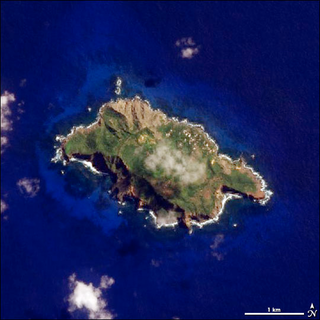
Pitcairn Island is the only inhabited island of the Pitcairn Islands, in the southern Pacific Ocean, of which many inhabitants are descendants of mutineers of HMS Bounty.

Bohol, officially the Province of Bohol, is an island province of the Philippines located in the Central Visayas region, consisting of the island itself and 75 minor surrounding islands. Its capital is Tagbilaran. With a land area of 4,821 km2 (1,861 sq mi) and a coastline 261 km (162 mi) long, Bohol is the tenth largest island of the Philippines.

The Mascarene Islands or Mascarenes or Mascarenhas Archipelago is a group of islands in the Indian Ocean east of Madagascar consisting of the islands belonging to the Republic of Mauritius as well as the French department of La Réunion. Their name derives from the Portuguese navigator Pedro Mascarenhas, who first visited them in April 1512. The islands share a common geologic origin in the volcanism of the Réunion hotspot beneath the Mascarene Plateau and form a distinct ecoregion with a unique flora and fauna.

The Comoro Islands or the Comoros are an archipelago of volcanic islands situated off the southeastern coast of Africa, to the east of Mozambique and northwest of Madagascar. The islands are politically divided between the Union of the Comoros, a sovereign country, and Mayotte, an Overseas Department of France.

The biodiversity of New Caledonia is of exceptional biological and paleoecological interest. It is frequently referred to as a biodiversity hotspot. The country is a large South Pacific archipelago with a total land area of more than 18,000 square kilometres (6,900 sq mi). The terrain includes a variety of reefs, atolls, small islands, and a variety of topographical and edaphic regions on the largest island, all of which promote the development of unusually concentrated biodiversity. The region's climate is oceanic and tropical.

The Federal Dependencies of Venezuela encompass most of Venezuela's offshore islands in the Caribbean Sea and the Gulf of Venezuela, excluding those islands that form the State of Nueva Esparta and some Caribbean coastal islands that are integrated with nearby states. These islands, with a total area of 342 square kilometres, are sparsely populated – according to the preliminary results of the 2011 Census only 2,155 people live there permanently, with another hundred from Margarita Island who live there seasonally to engage in fishing. Local government is officially under the authority of Central government in Caracas, although de facto power is often held by the heads of the sparse and somewhat isolated communities that decorate the territories.

Talibon, officially the Municipality of Talibon, is a 1st class municipality in the province of Bohol, Philippines. According to the 2020 census, it has a population of 71,272 people.

The fauna of Puerto Rico is similar to other island archipelago faunas, with high endemism, and low, skewed taxonomic diversity. Bats are the only extant native terrestrial mammals in Puerto Rico. All other terrestrial mammals in the area were introduced by humans, and include species such as cats, goats, sheep, the small Indian mongoose, and escaped monkeys. Marine mammals include dolphins, manatees, and whales. Of the 349 bird species, about 120 breed in the archipelago, and 47.5% are accidental or rare.
The Shoalwater Bay Military Training Area is a heritage-listed military installation at Byfield Road, Byfield, Shire of Livingstone, Queensland, Australia. It is a large, relatively undisturbed and intact natural system with a wide variety of coastal landforms and a high level of biodiversity. It contains a diverse range of marine and coastal wetland landscapes, vegetation types and ecosystems. It was added to the Australian Commonwealth Heritage List on 22 June 2004.

The Olango Island Group is a group of islands found in the Central Visayas region of the Philippines. It comprises Olango island and 6 satellite islets namely: Caubian, Camungi, Caohagan, Gilutongan, Nalusuan, Pangan-an, and Sulpa. The island group has a total land area of approximately 1,030 hectares. It is divided under the jurisdiction of the city of Lapu-Lapu and the municipality of Cordova, Cebu. It lies 5 kilometers (3.1 mi) east of Mactan and is a major tourist destination in Cebu. It is known for its wildlife sanctuary. The entire area is the first declared Ramsar Wetland Site in the Philippines, as recognized in 1994.

The Liquid Jungle Lab (LJL) is a tropical marine research station on the island of Canales de Tierra on the western coast of Pacific Panamá along a primary marine biological corridor. The LJL research campus was completed in 2004 and is part of a private 3,500 hectare reserve composed of primary forest, mangroves, tide pools, and a rocky inter-tidal zone that transitions into fringing coral reefs.

The Coral Triangle (CT) is a roughly triangular area in the tropical waters around the Philippines, Indonesia, Malaysia, Papua New Guinea, the Solomon Islands and Timor-Leste. This area contains at least 500 species of reef-building corals in each ecoregion. The Coral Triangle is located between the Pacific and Indian oceans and encompasses portions of two biogeographic regions: the Indonesian-Philippines Region, and the Far Southwestern Pacific Region. As one of eight major coral reef zones in the world, the Coral Triangle is recognized as a global centre of marine biodiversity and a global priority for conservation. Its biological resources make it a global hotspot of marine biodiversity. Known as the "Amazon of the seas", it covers 5.7 million square kilometres (2,200,000 sq mi) of ocean waters. It contains more than 76% of the world's shallow-water reef-building coral species, 37% of its reef fish species, 50% of its razor clam species, six out of seven of the world's sea turtle species, and the world's largest mangrove forest. In 2014, the Asian Development Bank (ADB) reported that the gross domestic product of the marine ecosystem in the Coral Triangle is roughly $1.2 trillion per year and provides food to over 120 million people. According to the Coral Triangle Knowledge Network, the region annually brings in about $3 billion in foreign exchange income from fisheries exports, and another $3 billion from coastal tourism revenues.

Aka Island is an island in the Pacific Ocean and is part of the Kerama Islands group in Okinawa Prefecture, Japan.

Morrocoy National Park is located in the easternmost coast of Falcón State and northwestern of Golfo Triste, in the west central Venezuelan coast, near the towns of Boca de Aroa, Tucacas, Sanare, Chichiriviche, Flamenco and Tocuyo de la Costa, and consisting of 12,990 hectares. It was declared a national park on May 26, 1974.
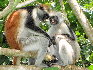
The wildlife of Zanzibar consists of terrestrial and marine flora and fauna in the archipelago of Zanzibar, an autonomous region of Tanzania. Its floral vegetation is categorized among the coastal forests of eastern Africa as the Southern Zanzibar-Inhambane coastal forest mosaic and the Northern Zanzibar-Inhambane coastal forest mosaic. Its faunal species are mostly small animals, birds, and butterflies.
The Danajon Bank is the only double barrier reef in the Philippines, which is a very rare geological formation, which is located in the Camotes Sea. It comprises two sets of large coral reefs that formed offshore on a submarine ridge due to a combination of favorable tidal currents and coral growth in the area.

The Maldives–Lakshadweep–Chagos Archipelago tropical moist forests is a tropical moist broadleaf forest ecoregion in South Asia. It spans a chain of coralline islands in the Indian Ocean, including Lakshadweep, a union territory of India; the Maldives, an independent country; and the British Indian Ocean Territory, an overseas territory of the United Kingdom.
Sri Lanka exhibits a remarkable biological diversity and is considered to be the richest country in Asia in terms of species concentration.
Ao Siam National Park is a national park that is preparing to reopen in Thailand. It is an area on the western coast of the Gulf of Thailand covering the Pa Klang Ao Forest Park, Mae Ramphueng Forest Park, Koh Talu, Koh Sing, and Koh Sanghk, Bang Saphan District Prachuap Khiri Khan Province. Which the three islands are 8 kilometers from the coast, 6 kilometers, and 5 kilometers, respectively. There are also some areas located in the drafting area of the Ministry of Natural Resources and Environment (Thailand) regarding environmental protection measures in some areas of Thap Sakae District, Kui Buri District, Sam Roi Yot District, Mueang Prachuap Khiri Khan District, Bang Saphan District, and Bang Saphan Noi District Prachuap Khiri Khan Province.
Nocnocan is an island off the coast of northern Bohol, Philippines. Located in the Camotes Sea, it a part of the chain of islands that are situated in the Danajon Bank, the only double barrier reef of the country. It is governed locally by Barangay Nocnocan, under the jurisdiction of the municipality of Talibon, Bohol. The island is around 13 km. northeast from the port of Talibon. Due to its proximity to the rich fishing grounds of the Danajon Reef, fishing is the main source of livelihood of the residents. They supply sea food, such as fish, crustaceans, mollusks and seaweeds to the markets in Bohol and Metro Cebu.
