Dauis

Last updated
Dauis
Mariveles
Municipality of Dauis
Dauis Bohol 1.JPG
Aerial view of Dauis, Panglao Island
Flag of Dauis, Bohol.png
Ph locator bohol dauis.png
Map of Bohol with Dauis highlighted
OpenStreetMap
Dauis
Philippines location map (square).svg
Red pog.svg
Dauis
Location within the Philippines
Coordinates: 9°37′30″N123°51′54″E / 9.625°N 123.865°E / 9.625; 123.865
CountryPhilippines
Region Central Visayas
Province Bohol
District 1st district
Barangays 12 (see Barangays)
Government
[1]
  Type Sangguniang Bayan
   Mayor Roman B. Bullen
   Vice Mayor Marietta T. Sumaylo
   Representative Edgardo M. Chatto
   Municipal Council
Members
   Electorate 31,781 voters (2022)
Area
[2]
  Total43.33 km2 (16.73 sq mi)
Elevation
[3]
34 m (112 ft)
Highest elevation
192 m (630 ft)
Lowest elevation
0 m (0 ft)
Population
 (2020 census) [4]
  Total52,492
  Density1,200/km2 (3,100/sq mi)
   Households
11,522
Economy
   Income class 4th municipal income class
   Poverty incidence
10.80
% (2018) [5]
   Revenue 165.3 million (2020)
   Assets 413.1 million (2020)
   Expenditure 138.8 million (2020)
   Liabilities 59.78 million (2020)
Time zone UTC+8 (PST)
ZIP code
6339
PSGC
IDD : area code +63(0)38
Native languages Boholano dialect
Cebuano
Tagalog

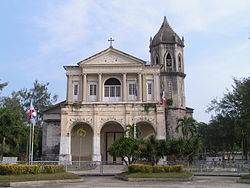
Dauis, officially the Municipality of Dauis (Cebuano : Munisipalidad sa Dauis; Tagalog : Bayan ng Dauis), is a 4th class municipality in the province of Bohol, Philippines. According to the 2020 census, it has a population of 52,492 people. [4] The town has many fine beaches, resorts, and a historic church, built in the 17th century. The Hinagdanan Cave is also a draw for tourists.

Contents

History

Dauis is one of the oldest municipalities of Bohol, as attested by the discovery of early Chinese artifacts in the 1970s. All records of the town were destroyed in World War Two, however church records show the parish was established in 1697. The stone watchtower, now only ruins, was built in 1774. [6]

The first bridge between Poblacion of Dauis and Mansasa, Tagbilaran, was constructed by Spaniards during their reign, possibly in the 18th century. The bridge is still in place, used as a connection between the two islands. The other bridge was constructed near the old City Hall of Tagbilaran City, crossing towards Totolan. That bridge is known as 'the causeway' and leads as far as Panglao Beach resort about 17 kilometres (11 mi) from Tagbilaran.

A deep well was constructed in Poblacion in 1900 by a Spanish leader where the well is now located, inside the Church below the altar. The locals provided the labor. The well depth is about 30 fathoms (55 m; 180 ft) and the diameter three metres (9.8 ft). The well was constructed through manual digging using bolos, crowbars, pulleys, and rope for digging into the soil stones, which contains limestone rock.

Geography

Dauis is located in the northern part of Panglao Island. It is 3 kilometres (1.9 mi) from Tagbilaran.

Barangays

Dauis is politically subdivided into 12 barangays. Each barangay consists of puroks and some have sitios.

PSGC Barangay Population ±% p.a.
2020 [4] 2010 [7]
071219001 Biking 6.5% 3,428 3,334 0.28% 
071219002 Bingag 8.5% 4,436 3,877 1.36% 
071219004 Catarman 9.0% 4,749 4,373 0.83% 
071219005 Dao 2.9% 1,514 1,331 1.30% 
071219012 Mariveles 7.0% 3,664 3,216 1.31% 
071219006 Mayacabac 7.5% 3,934 3,469 1.27% 
071219007 Poblacion 5.9% 3,074 2,672 1.41% 
071219003 San Isidro (Canlongon) 2.5% 1,330 1,238 0.72% 
071219008 Songculan 8.3% 4,375 3,870 1.23% 
071219009 Tabalong 10.2% 5,375 4,410 2.00% 
071219010 Tinago 5.2% 2,753 2,169 2.41% 
071219011 Totolan 13.4% 7,031 5,479 2.52% 
Total52,49239,4482.90%
Circle frame.svgTotolan: 7,031 (15.4%)Tabalong: 5,375 (11.8%)Catarman: 4,749 (10.4%)Bingag: 4,436 (9.7%)Songculan: 4,375 (9.6%)Mayacabac: 3,934 (8.6%)Mariveles: 3,664 (8.0%)Biking: 3,428 (7.5%)Poblacion: 3,074 (6.7%)Tinago: 2,753 (6.0%)Dao: 1,514 (3.3%)San Isidro (Canlongon): 1,330 (2.9%)

Climate

Climate data for Dauis, Bohol
MonthJanFebMarAprMayJunJulAugSepOctNovDecYear
Average high °C (°F)28
(82)
29
(84)
30
(86)
31
(88)
31
(88)
30
(86)
30
(86)
30
(86)
30
(86)
29
(84)
29
(84)
29
(84)
30
(85)
Average low °C (°F)23
(73)
22
(72)
23
(73)
23
(73)
24
(75)
25
(77)
24
(75)
24
(75)
24
(75)
24
(75)
23
(73)
23
(73)
24
(74)
Average precipitation mm (inches)102
(4.0)
85
(3.3)
91
(3.6)
75
(3.0)
110
(4.3)
141
(5.6)
121
(4.8)
107
(4.2)
111
(4.4)
144
(5.7)
169
(6.7)
139
(5.5)
1,395
(55.1)
Average rainy days18.614.816.516.723.926.425.624.124.426.323.720.5261.5
Source: Meteoblue (Use with caution: this is modeled/calculated data, not measured locally.) [8]

Demographics

Population census of Dauis
YearPop.±% p.a.
1903 8,378    
1918 10,275+1.37%
1939 12,154+0.80%
1948 12,303+0.14%
1960 13,595+0.84%
YearPop.±% p.a.
1970 15,812+1.52%
1975 17,955+2.58%
1980 18,260+0.34%
1990 23,601+2.60%
1995 24,041+0.35%
YearPop.±% p.a.
2000 26,415+2.04%
2007 36,525+4.57%
2010 39,448+2.84%
2015 45,663+2.83%
2020 52,492+2.78%
Source: Philippine Statistics Authority [9] [7] [10] [11]

Economy

Culture

The town's 18th-century church, is dedicated to La Señora de la Asuncion or Our Lady of the Assumption. The church is believed to have been built of light materials by the first Spanish missionaries in 1697. Since then, the church has gone through several changes.

The image of the La Señora de la Asuncion is famed to be miraculous. Faithfuls come from near and far to hike the distance from the city to the site to invoke special petitions or mainly to honor the Patroness. In addition, at the foot of the altar of the church is a well also believed to have healing power. The water tastes fresh, despite the well's proximity to the seashore.

15 August

The town and all devotees of the La Señora de la Asuncion attend the Patroness' feast day every 15 August. Stories abound of the Patroness' sojourn and blessings. One of the stories tells of a man who found a camiseta (blouse) in his fishing boat after a lady passenger disembarked. On several occasions, devotees found the Patroness' camiseta full of amorseco. Many believe the Patroness must, on occasions, get down from her pedestal to visit them in their homes and farms. To this day, devotees continue to venerate and pay homage as manifestation of gratitude and appreciation after being healed of their ailments through the camiseta.

Last Sunday of January

Another fiesta is celebrated last Sunday of January, to commemorate a miracle that happened many years back. It is said that many young girls have seen the lady waving her hands as if bidding them to come near.

Tourism

Dauis's major tourist attractions are Our Lady of Assumption Church and Hinagdanan Cave. Our Lady of Assumption Church is locally known as Señora de la Asunción. The church was built by Boholanos under forced labor imposed by the Spanish. It is constructed of solid rocks or stones and has paintings on the walls. There is a tower with a bell, outside the church another tower and also a small well. The front face of the church collapsed during the earthquake of 2013.

Related Research Articles

<span class="mw-page-title-main">Tagbilaran</span> Capital of Bohol, Philippines

Tagbilaran, officially the City of Tagbilaran, is a 3rd class component city and capital of the province of Bohol, Philippines. According to the 2020 census, it has a population of 104,976 people.

<span class="mw-page-title-main">Corella, Bohol</span> Municipality in Bohol, Philippines

Corella, officially the Municipality of Corella, is a 5th class municipality in the province of Bohol, Philippines. According to the 2020 census, it has a population of 9,479 people.

<span class="mw-page-title-main">Alicia, Bohol</span> Municipality in Bohol, Philippines

Alicia, officially the Municipality of Alicia, is a 4th class municipality in the province of Bohol, Philippines. According to the 2020 census, it has a population of 24,374 people.

<span class="mw-page-title-main">Baclayon</span> Municipality in Bohol, Philippines

Baclayon, officially the Municipality of Baclayon, is a 4th class municipality in the province of Bohol, Philippines. According to the 2020 census, it has a population of 22,461 people.

<span class="mw-page-title-main">Bilar, Bohol</span> Municipality in Bohol, Philippines

Bilar, officially the Municipality of Bilar, is a 4th class municipality in the province of Bohol, Philippines. According to the 2020 census, it has a population of 18,512 people.

<span class="mw-page-title-main">Carmen, Bohol</span> Municipality in Bohol, Philippines

Carmen, officially the Municipality of Carmen, is a 1st class municipality in the province of Bohol, Philippines. According to the 2020 census, it has a population of 49,191 people.

<span class="mw-page-title-main">Clarin, Bohol</span> Municipality in Bohol, Philippines

Clarin, officially the Municipality of Clarin, is a 5th class municipality in the province of Bohol, Philippines. According to the 2020 census, it has a population of 21,158 people.

<span class="mw-page-title-main">Cortes, Bohol</span> Municipality in Bohol, Philippines

Cortes, officially the Municipality of Cortes, is a 5th class municipality in the province of Bohol, Philippines. According to the 2020 census, it has a population of 18,344 people.

<span class="mw-page-title-main">Dagohoy, Bohol</span> Municipality in Bohol, Philippines

Dagohoy, officially the Municipality of Dagohoy, is a 5th class municipality in the province of Bohol, Philippines. According to the 2020 census, it has a population of 19,874 people.

<span class="mw-page-title-main">Jagna</span> Municipality in Bohol, Philippines

Jagna, officially the Municipality of Jagna, is a 3rd class municipality in the province of Bohol, Philippines. According to the 2020 census, it has a population of 35,832 people.

<span class="mw-page-title-main">Getafe, Bohol</span> Municipality in Bohol, Philippines

Getafe, officially the Municipality of Getafe and also spelled as Jetafe, is a 3rd class municipality in the province of Bohol, Philippines. According to the 2020 census, it has a population of 33,422 people.

<span class="mw-page-title-main">Lila, Bohol</span> Municipality in Bohol, Philippines

Lila, officially the Municipality of Lila, is a 5th class municipality in the province of Bohol, Philippines. According to the 2020 census, it has a population of 12,240 people.

<span class="mw-page-title-main">Loay, Bohol</span> Municipality in Bohol, Philippines

Loay, officially the Municipality of Loay, is a 5th class municipality in the province of Bohol, Philippines. According to the 2020 census, it has a population of 17,855 people.

<span class="mw-page-title-main">Loon, Bohol</span> Municipality in Bohol, Philippines

Loon, officially the Municipality of Loon, is a 2nd class municipality in the province of Bohol, Philippines which was established in 1753. According to the 2020 census, it has a population of 44,224 people.

<span class="mw-page-title-main">Maribojoc</span> Municipality in Bohol, Philippines

Maribojoc, officially the Municipality of Maribojoc, is a 4th class municipality in the province of Bohol, Philippines. According to the 2020 census, it has a population of 22,178 people.

<span class="mw-page-title-main">Panglao, Bohol</span> Municipality in Bohol, Philippines

Panglao, officially the Municipality of Panglao, is a 4th class municipality in the province of Bohol, Philippines. According to the 2020 census, it has a population of 39,839 people.

<span class="mw-page-title-main">Sevilla, Bohol</span> Municipality in Bohol, Philippines

Sevilla, officially the Municipality of Sevilla, is a 5th class municipality in the province of Bohol, Philippines. According to the 2020 census, it has a population of 11,376 people.

<span class="mw-page-title-main">Tubigon</span> Municipality in Bohol, Philippines

Tubigon, officially the Municipality of Tubigon, is a 1st class municipality in the province of Bohol, Philippines. According to the 2020 census, it has a population of 47,886 people.

<span class="mw-page-title-main">Valencia, Bohol</span> Municipality in Bohol, Philippines

Valencia, officially the Municipality of Valencia, is a 4th class municipality in the province of Bohol, Philippines. According to the 2020 census, it has a population of 28,392 people.

<span class="mw-page-title-main">Panglao Island</span> Island in the province of Bohol in the Philippines

Panglao is an island in the north Bohol Sea, located in the Central Visayas region of the Visayas island group, in the south-central Philippines.

References

  1. Municipality of Dauis | (DILG)
  2. "2015 Census of Population, Report No. 3 – Population, Land Area, and Population Density" (PDF). Philippine Statistics Authority. Quezon City, Philippines. August 2016. ISSN   0117-1453. Archived (PDF) from the original on May 25, 2021. Retrieved July 16, 2021.
  3. Error: Unable to display the reference properly. See the documentation for details.
  4. 1 2 3 Census of Population (2020). "Region VII (Central Visayas)". Total Population by Province, City, Municipality and Barangay. Philippine Statistics Authority . Retrieved 8 July 2021.{{cite encyclopedia}}: CS1 maint: numeric names: authors list (link)
  5. "PSA Releases the 2018 Municipal and City Level Poverty Estimates". Philippine Statistics Authority. 15 December 2021. Retrieved 22 January 2022.
  6. "Attractions of Dauis Town Bohol Philippines". www.bohol-philippines.com. Retrieved 2022-11-22.
  7. 1 2 Census of Population and Housing (2010). "Region VII (Central Visayas)" (PDF). Total Population by Province, City, Municipality and Barangay. National Statistics Office . Retrieved 29 June 2016.{{cite encyclopedia}}: CS1 maint: numeric names: authors list (link)
  8. "Dauis: Average Temperatures and Rainfall". Meteoblue. Retrieved 9 May 2020.
  9. Census of Population (2015). "Region VII (Central Visayas)". Total Population by Province, City, Municipality and Barangay. Philippine Statistics Authority . Retrieved 20 June 2016.{{cite encyclopedia}}: CS1 maint: numeric names: authors list (link)
  10. Censuses of Population (1903–2007). "Region VII (Central Visayas)". Table 1. Population Enumerated in Various Censuses by Province/Highly Urbanized City: 1903 to 2007. National Statistics Office.{{cite encyclopedia}}: CS1 maint: numeric names: authors list (link)
  11. "Province of". Municipality Population Data. Local Water Utilities Administration Research Division. Retrieved 17 December 2016.
  12. "Poverty incidence (PI):". Philippine Statistics Authority. Retrieved December 28, 2020.
  13. "Estimation of Local Poverty in the Philippines" (PDF). Philippine Statistics Authority. 29 November 2005.
  14. "2003 City and Municipal Level Poverty Estimates" (PDF). Philippine Statistics Authority. 23 March 2009.
  15. "City and Municipal Level Poverty Estimates; 2006 and 2009" (PDF). Philippine Statistics Authority. 3 August 2012.
  16. "2012 Municipal and City Level Poverty Estimates" (PDF). Philippine Statistics Authority. 31 May 2016.
  17. "Municipal and City Level Small Area Poverty Estimates; 2009, 2012 and 2015". Philippine Statistics Authority. 10 July 2019.
  18. "PSA Releases the 2018 Municipal and City Level Poverty Estimates". Philippine Statistics Authority. 15 December 2021. Retrieved 22 January 2022.