Sagbayan

Last updated
Sagbayan
Borja
Municipality of Sagbayan
Sagbayan San Agustin top view, Route 853, chocolate hills (Sagbayan, Bohol; 01-13-2023).jpg
San Agustin
Flag of Sagbayan, Bohol.png
Ph locator bohol sagbayan.png
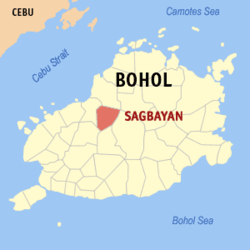
Map of Bohol with Sagbayan highlighted
OpenStreetMap
Sagbayan
Philippines location map (square).svg
Red pog.svg
Sagbayan
Location within the Philippines
Coordinates: 9°55′N124°06′E / 9.92°N 124.1°E / 9.92; 124.1
Country Philippines
Region Central Visayas
Province Bohol
District 2nd district
Founded February 9, 1949
Renamed June 21, 1957
Barangays 24 (see Barangays)
Government
[1]
  Type Sangguniang Bayan
   Mayor Restituto Q. Suarez III
   Vice Mayor Asuncion B. Ybañez
   Representative Ma. Vanessa C. Aumentado
   Municipal Council
Members
   Electorate 16,758 voters (2022)
Area
[2]
  Total69.61 km2 (26.88 sq mi)
Elevation
424 m (1,391 ft)
Highest elevation
327 m (1,073 ft)
Lowest elevation
47 m (154 ft)
Population
 (2020 census) [3]
  Total24,335
  Density350/km2 (910/sq mi)
   Households
5,897
Economy
   Income class 4th municipal income class
   Poverty incidence
21.50
% (2018) [4]
   Revenue 113.5 million (2020)
   Assets 337.3 million (2020)
   Expenditure 137 million (2020)
   Liabilities 45.93 million (2020)
Service provider
  ElectricityBohol 1 Electric Cooperative (BOHECO 1)
Time zone UTC+8 (PST)
ZIP code
6331
PSGC
IDD : area code +63(0)38
Native languages Boholano dialect
Cebuano
Tagalog

Sagbayan, officially the Municipality of Sagbayan (Cebuano : Munisipyo sa Sagbayan; Tagalog : Bayan ng Sagbayan), is a 4th class municipality in the province of Bohol, Philippines. According to the 2020 census, it has a population of 24,335 people. [3]

Contents

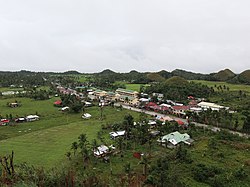
Its main attraction is Sagbayan Peak, a tourism site overlooking a scenic valley with an observation platform and children's playground. [5] While some similar hill formations are visible, it is not within the main Chocolate Hills area.

Sagbayan is 74 kilometres (46 mi) from Tagbilaran.

Sagbayan celebrates its feast on May 4/August 28, to honor the town patron San Agustin. [6]

Etymology

The name Sagbayan came from the combination of the local words Sag which means nest, and Bay (short of Balay) which means house. Therefore, Sagbayan means a place for making tree-houses.

Long ago, the place was said to be plentiful of deer and wild pig. People often visit the place to hunt them. They constructed tree houses while waiting for their prey to appear. As time goes, these animals were depopulated, leaving only tree houses left by the hunters. [7]

The proper pronunciation of word Ságbayan has a stress on its first syllable, [7] not Sagbayán, which has stress on its suffix -an, therefore debunking the word Sagbayán which means a place to hang. [8]

History

Sagbayan was formerly part of the surrounding municipalities of Clarin, Inabanga, Carmen, and Balilihan. It was created into a separate town through Executive Order No. 204 of President Elpidio Quirino on February 9, 1949, and named Borja, [9] in honor of Salustiano Borja, the first elected civil governor of the Province of Bohol. [8]

The original list of its barangays and sitios were Sagbayan, Canmaya Centro, Canmaya Diot, Canmano, San Antonio, and San Isidro, and the sitios of Santa Cruz, San Vicente Norte, San Vicente Sur, San Ramon, and Kalangahan (Calangahan), from Clarin; the sitios of Mantalongon and Katipunan from Inabanga, and the sitios of Cabasacan (Kabasacan) and Ubuhan (Ubojan) from Balilihan (note: Catigbian is still part of Balilihan until its reorganization on June 17, 1949 [10] ). Barangay Sagbayan became its Poblacion which is the seat of government of the municipality.

Through the Republic Act No. 1741, it was reverted to its original name, Sagbayan on June 21, 1957, signed by President Carlos P. Garcia. [11]

On October 15, 2013, Sagbayan was close to the epicenter of a magnitude 7.2 earthquake. The town suffered 12 fatalities and damage to almost 1,000 homes, as well as total destruction of its town hall. [12]

Geography

Barangays

Sagbayan is politically subdivded into 24 barangays. Each barangay consists of puroks and some have sitios.

PSGC Barangay Population ±% p.a.
2020 [3] 2010 [13]
071236001 Calangahan 3.9% 957 910 0.50%
071236002 Canmano 3.9% 947 1,006 −0.60%
071236003 Canmaya Centro 6.0% 1,448 1,317 0.95%
071236004 Canmaya Diot 5.0% 1,221 1,161 0.51%
071236005 Dagnawan 3.5% 842 525 4.84%
071236006 Kabasacan 2.2% 539 490 0.96%
071236007 Kagawasan 1.5% 376 370 0.16%
071236008 Katipunan 2.4% 591 600 −0.15%
071236009 Langtad 2.2% 530 570 −0.72%
071236010 Libertad Norte 1.5% 353 316 1.11%
071236011 Libertad Sur 0.5% 117 184 −4.43%
071236012 Mantalongon 3.9% 952 707 3.02%
071236013 Poblacion 17.1% 4,154 3,945 0.52%
071236014 Sagbayan Sur 4.8% 1,170 1,011 1.47%
071236015 San Agustin 4.3% 1,037 867 1.81%
071236016 San Antonio 4.0% 966 852 1.26%
071236017 San Isidro 3.6% 882 736 1.83%
071236018 San Ramon 2.3% 563 405 3.35%
071236019 San Roque 1.8% 434 420 0.33%
071236020 San Vicente Norte 3.2% 789 715 0.99%
071236021 San Vicente Sur 1.2% 302 290 0.41%
071236022 Santa Catalina 4.7% 1,136 721 4.65%
071236023 Santa Cruz 3.8% 920 985 −0.68%
071236024 Ubojan 4.6% 1,113 988 1.20%
Total24,33520,0911.93%

Climate

Climate data for Sagbayan, Bohol
MonthJanFebMarAprMayJunJulAugSepOctNovDecYear
Mean daily maximum °C (°F)26
(79)
27
(81)
28
(82)
29
(84)
30
(86)
29
(84)
28
(82)
29
(84)
29
(84)
28
(82)
27
(81)
27
(81)
28
(83)
Mean daily minimum °C (°F)21
(70)
21
(70)
21
(70)
22
(72)
23
(73)
23
(73)
22
(72)
22
(72)
22
(72)
22
(72)
22
(72)
22
(72)
22
(72)
Average precipitation mm (inches)98
(3.9)
82
(3.2)
96
(3.8)
71
(2.8)
104
(4.1)
129
(5.1)
101
(4.0)
94
(3.7)
99
(3.9)
135
(5.3)
174
(6.9)
143
(5.6)
1,326
(52.3)
Average rainy days18.014.117.116.823.725.725.823.324.225.924.020.6259.2
Source: Meteoblue [14]

Demographics

Population census of Sagbayan
YearPop.±% p.a.
1960 8,720    
1970 10,822+2.18%
1975 12,500+2.93%
1980 12,703+0.32%
1990 15,364+1.92%
1995 16,488+1.33%
2000 18,346+2.32%
2007 19,399+0.77%
2010 20,091+1.28%
2015 22,339+2.04%
2020 24,335+1.70%
Source: Philippine Statistics Authority [15] [13] [16] [17]

Economy

See also

Related Research Articles

<span class="mw-page-title-main">Alicia, Bohol</span> Municipality in Bohol, Philippines

Alicia, officially the Municipality of Alicia, is a 4th class municipality in the province of Bohol, Philippines. According to the 2020 census, it has a population of 24,374 people.

<span class="mw-page-title-main">Antequera, Bohol</span> Municipality in Bohol, Philippines

Antequera, officially the Municipality of Antequera, is a 4th class municipality in the province of Bohol, Philippines. According to the 2020 census, it has a population of 14,990 people.

<span class="mw-page-title-main">Baclayon</span> Municipality in Bohol, Philippines

Baclayon, officially the Municipality of Baclayon, is a 4th class municipality in the province of Bohol, Philippines. According to the 2020 census, it has a population of 22,461 people.

<span class="mw-page-title-main">Batuan, Bohol</span> Municipality in Bohol, Philippines

Batuan, officially the Municipality of Batuan, is a 5th class municipality in the province of Bohol, Philippines. According to the 2020 census, it has a population of 13,845 people.

<span class="mw-page-title-main">Bilar, Bohol</span> Municipality in Bohol, Philippines

Bilar, officially the Municipality of Bilar, is a 4th class municipality in the province of Bohol, Philippines. According to the 2020 census, it has a population of 18,512 people.

<span class="mw-page-title-main">Buenavista, Bohol</span> Municipality in Bohol, Philippines

Buenavista, officially the Municipality of Buenavista, is a 4th class municipality in the province of Bohol, Philippines. According to the 2020 census, it has a population of 29,711 people.

<span class="mw-page-title-main">Carmen, Bohol</span> Municipality in Bohol, Philippines

Carmen, officially the Municipality of Carmen, is a 1st class municipality in the province of Bohol, Philippines. According to the 2020 census, it has a population of 49,191 people.

<span class="mw-page-title-main">Catigbian</span> Municipality in Bohol, Philippines

Catigbian, officially the Municipality of Catigbian, is a 4th class municipality in the province of Bohol, Philippines. According to the 2020 census, it has a population of 23,805 people.

<span class="mw-page-title-main">Clarin, Bohol</span> Municipality in Bohol, Philippines

Clarin, officially the Municipality of Clarin, is a 5th class municipality in the province of Bohol, Philippines. According to the 2020 census, it has a population of 21,158 people.

<span class="mw-page-title-main">Dagohoy, Bohol</span> Municipality in Bohol, Philippines

Dagohoy, officially the Municipality of Dagohoy, is a 5th class municipality in the province of Bohol, Philippines. According to the 2020 census, it has a population of 19,874 people.

<span class="mw-page-title-main">Danao, Bohol</span> Municipality in Bohol, Philippines

Danao, officially the Municipality of Danao, is a 4th class municipality in the province of Bohol, Philippines. According to the 2020 census, it has a population of 20,245 people.

<span class="mw-page-title-main">Inabanga</span> Municipality in Bohol, Philippines

Inabanga, officially the Municipality of Inabanga, is a 3rd class municipality in the province of Bohol, Philippines. According to the 2020 census, it has a population of 48,534 people.

<span class="mw-page-title-main">Getafe, Bohol</span> Municipality in Bohol, Philippines

Getafe, officially the Municipality of Getafe and also spelled as Jetafe, is a 3rd class municipality in the province of Bohol, Philippines. According to the 2020 census, it has a population of 33,422 people.

<span class="mw-page-title-main">Mabini, Bohol</span> Municipality in Bohol, Philippines

Mabini, officially the Municipality of Mabini, is a 4th class municipality in the province of Bohol, Philippines. According to the 2020 census, it has a population of 28,701 people.

<span class="mw-page-title-main">Maribojoc</span> Municipality in Bohol, Philippines

Maribojoc, officially the Municipality of Maribojoc, is a 4th class municipality in the province of Bohol, Philippines. According to the 2020 census, it has a population of 22,178 people.

<span class="mw-page-title-main">San Isidro, Bohol</span> Municipality in Bohol, Philippines

San Isidro, officially the Municipality of San Isidro, is a 5th class municipality in the province of Bohol, Philippines. According to the 2020 census, it has a population of 9,909 people.

<span class="mw-page-title-main">San Miguel, Bohol</span> Municipality in Bohol, Philippines

San Miguel, officially the Municipality of San Miguel, is a 4th class municipality in the province of Bohol, Philippines. According to the 2020 census, it has a population of 25,356 people.

<span class="mw-page-title-main">Sikatuna, Bohol</span> Municipality in Bohol, Philippines

Sikatuna, officially the Municipality of Sikatuna, is a 5th class municipality in the province of Bohol, Philippines. According to the 2020 census, it has a population of 6,906 people.

<span class="mw-page-title-main">Trinidad, Bohol</span> Municipality in Bohol, Philippines

Trinidad, officially the Municipality of Trinidad, is a 3rd class municipality in the province of Bohol, Philippines. According to the 2020 census, it has a population of 35,119 people.

<span class="mw-page-title-main">Tubigon</span> Municipality in Bohol, Philippines

Tubigon, officially the Municipality of Tubigon, is a 1st class municipality in the province of Bohol, Philippines. According to the 2020 census, it has a population of 47,886 people.

References

  1. Municipality of Sagbayan | (DILG)
  2. "2015 Census of Population, Report No. 3 – Population, Land Area, and Population Density" (PDF). Philippine Statistics Authority. Quezon City, Philippines. August 2016. ISSN   0117-1453. Archived (PDF) from the original on May 25, 2021. Retrieved July 16, 2021.
  3. 1 2 3 Census of Population (2020). "Region VII (Central Visayas)". Total Population by Province, City, Municipality and Barangay. Philippine Statistics Authority . Retrieved 8 July 2021.
  4. "PSA Releases the 2018 Municipal and City Level Poverty Estimates". Philippine Statistics Authority. 15 December 2021. Retrieved 22 January 2022.
  5. "Best of Bohol Attractions". www.bohol-philippines.com. Retrieved 2019-02-21.
  6. "Bohol Festivals Timetable". www.bohol-philippines.com. Retrieved 2019-04-01.
  7. 1 2 Jes B. Tirol (March 13, 2011). "Toponyms of Bohol and its Towns, Part 10". Bohol Chronicle.
  8. 1 2 "Municipality of Sagbayan". Province of Bohol. Retrieved 2012-09-20.
  9. Executive Order No. 1949 (9 February 1949), Organizing certain barrios and sitios of the municipalities of Clarin, Inabanga and Balilihan, province of Bohol, into an independent municipality under the name of Borja
  10. Executive Order No. 229 (17 June 1949), ORGANIZING CERTAIN PORTIONS OF THE MUNICIPALITIES OF BALILIHAN, ANTEQUERA AND TUBIGON, ALL OF THE PROVINCE OF BOHOL, INTO AN INDEPENDENT MUNICIPALITY UNDER THE NAME OF SAN JACINTO. (PDF)
  11. Republic Act No. 1741 (21 June 1957), An Act Changing the Name of the Municipality of Borja, Province of Bohol, to Sagbayan
  12. "SitRep No. 35 re Effects of Magnitude 7.2 Sagbayan, Bohol Earthquake" (PDF). National Disaster Risk Reduction and Management Council. November 3, 2013. Retrieved November 7, 2013.
  13. 1 2 Census of Population and Housing (2010). "Region VII (Central Visayas)" (PDF). Total Population by Province, City, Municipality and Barangay. National Statistics Office . Retrieved 29 June 2016.
  14. "Sagbayan: Average Temperatures and Rainfall". Meteoblue. Retrieved 9 May 2020.
  15. Census of Population (2015). "Region VII (Central Visayas)". Total Population by Province, City, Municipality and Barangay. Philippine Statistics Authority . Retrieved 20 June 2016.
  16. Censuses of Population (1903–2007). "Region VII (Central Visayas)". Table 1. Population Enumerated in Various Censuses by Province/Highly Urbanized City: 1903 to 2007. National Statistics Office.{{cite encyclopedia}}: CS1 maint: numeric names: authors list (link)
  17. "Province of Bohol". Municipality Population Data. Local Water Utilities Administration Research Division. Retrieved 17 December 2016.
  18. "Poverty incidence (PI):". Philippine Statistics Authority. Retrieved December 28, 2020.
  19. "Estimation of Local Poverty in the Philippines" (PDF). Philippine Statistics Authority. 29 November 2005.
  20. "2003 City and Municipal Level Poverty Estimates" (PDF). Philippine Statistics Authority. 23 March 2009.
  21. "City and Municipal Level Poverty Estimates; 2006 and 2009" (PDF). Philippine Statistics Authority. 3 August 2012.
  22. "2012 Municipal and City Level Poverty Estimates" (PDF). Philippine Statistics Authority. 31 May 2016.
  23. "Municipal and City Level Small Area Poverty Estimates; 2009, 2012 and 2015". Philippine Statistics Authority. 10 July 2019.
  24. "PSA Releases the 2018 Municipal and City Level Poverty Estimates". Philippine Statistics Authority. 15 December 2021. Retrieved 22 January 2022.