San Isidro, Bohol

Last updated
San Isidro
Municipality of San Isidro
San Isidro Bohol 1.jpg
Municipal Hall of San Isidro
Flag of San Isidro, Bohol.png
Ph locator bohol san isidro.png
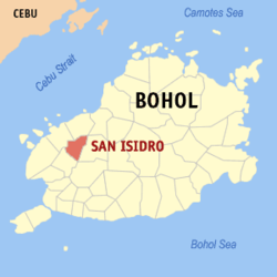
Map of Bohol with San Isidro highlighted
OpenStreetMap
San Isidro, Bohol
Philippines location map (square).svg
Red pog.svg
San Isidro
Location within the Philippines
Coordinates: 9°48′N124°18′E / 9.8°N 124.3°E / 9.8; 124.3
Country Philippines
Region Central Visayas
Province Bohol
District 2nd district
Founded 21 June 1969
Barangays 12 (see Barangays)
Government
[1]
  Type Sangguniang Bayan
   Mayor Diosdado N. Gementiza Jr.
   Vice Mayor Filemon R. Mantabote
   Representative Erico Aristotle C. Aumentado
   Municipal Council
Members
  • Henston M. Sandigan
  • Zinas V. Arambala
  • Danilo B. Saligumba
  • Ruby M. Lurot
  • Clemen M. Jala
  • Jorge L. Cosmod
  • Jacinto B. Naraga
  • Lourdes R. Samuya
   Electorate 7,407 voters (2025)
Area
[2]
  Total
60.04 km2 (23.18 sq mi)
Elevation
220 m (720 ft)
Highest elevation
466 m (1,529 ft)
Lowest elevation
15 m (49 ft)
Population
 (2024 census) [3]
  Total
10,228
  Density170/km2 (440/sq mi)
   Households
2,380
Economy
   Income class 5th municipal income class
   Poverty incidence
26.95
% (2021) [4]
   Revenue 101.6 million (2022)
   Assets 216.8 million (2022)
   Expenditure 113.7 million (2022)
   Liabilities 35.95 million (2022)
Service provider
  ElectricityBohol 1 Electric Cooperative (BOHECO 1)
Time zone UTC+8 (PST)
ZIP code
6345
PSGC
IDD : area code +63(0)38
Native languages Boholano dialect
Cebuano
Tagalog

San Isidro, officially the Municipality of San Isidro (Cebuano : Munisipalidad sa San Isidro; Tagalog : Bayan ng San Isidro), is a municipality in the province of Bohol, Philippines. According to the 2020 census, it has a population of 9,909 people. [5]

Contents

This town is quite unique because it is the only town covered by the 2nd District surrounded by towns of the 1st District. San Isidro is 31 kilometres (19 mi) from Tagbilaran.

The town of San Isidro, Bohol celebrates its feast on May 15, to honor the town patron Saint Isidore the Laborer. [6]

Geography

Barangays

San Isidro is politically subdivided into 12 barangays. Each barangay consists of puroks and some have sitios.

Currently, Barangay Poblacion is classified as urban and the rest are rural.

PSGC Barangay Population ±% p.a.
2024 [7] 2010 [8]
071237002 Abehilan 6.1% 620 621 −0.01% 
071237014 Baryong Daan 2.9% 292 288 0.10% 
071237003 Baunos 4.2% 432 479 −0.72% 
071237005 Cabanugan 9.3% 949 892 0.44% 
071237006 Caimbang 6.2% 638 668 −0.32% 
071237007 Cambansag 7.0% 718 683 0.35% 
071237008 Candungao 9.0% 922 1,130 −1.42% 
071237009 Cansague Norte 3.9% 404 414 −0.17% 
071237010 Cansague Sur 5.7% 581 565 0.20% 
071237011 Causwagan Sur 5.7% 580 613 −0.39% 
071237012 Masonoy 4.6% 473 547 −1.02% 
071237013 Poblacion 20.9% 2,135 2,225 −0.29% 
Total10,2289,1250.81%
Circle frame.svgPoblacion: 2,135 (24.2%)Cabanugan: 949 (10.8%)Candungao: 922 (10.5%)Cambansag: 718 (8.1%)Caimbang: 638 (7.2%)Abehilan: 620 (7.0%)Cansague Sur: 581 (6.6%)Causwagan Sur: 580 (6.6%)Masonoy: 547 (6.2%)Baunos: 432 (4.9%)Cansague Norte: 404 (4.6%)Baryong Daan: 288 (3.3%)

Climate

Climate data for San Isidro, Bohol
MonthJanFebMarAprMayJunJulAugSepOctNovDecYear
Mean daily maximum °C (°F)26
(79)
27
(81)
28
(82)
30
(86)
30
(86)
29
(84)
28
(82)
29
(84)
29
(84)
28
(82)
27
(81)
27
(81)
28
(83)
Mean daily minimum °C (°F)22
(72)
21
(70)
21
(70)
22
(72)
23
(73)
23
(73)
22
(72)
22
(72)
22
(72)
22
(72)
22
(72)
22
(72)
22
(72)
Average precipitation mm (inches)98
(3.9)
82
(3.2)
96
(3.8)
71
(2.8)
104
(4.1)
129
(5.1)
101
(4.0)
94
(3.7)
99
(3.9)
135
(5.3)
174
(6.9)
143
(5.6)
1,326
(52.3)
Average rainy days18.014.117.116.823.725.725.823.324.225.924.020.6259.2
Source: Meteoblue [9]

Demographics

Population census of San Isidro
YearPop.±% p.a.
1970 6,923    
1975 7,281+1.02%
1980 7,369+0.24%
1990 7,840+0.62%
1995 7,548−0.71%
2000 9,106+4.10%
2007 9,176+0.11%
2010 9,125−0.20%
2015 8,744−0.81%
2020 9,909+2.67%
2024 10,228+0.76%
Source: Philippine Statistics Authority [10] [11] [8] [12] [13]

Economy

Poverty incidence of San Isidro

10
20
30
40
50
60
70
2000
54.71
2003
29.60
2006
47.80
2009
64.01
2012
44.89
2015
30.88
2018
25.80
2021
26.95

Source: Philippine Statistics Authority [14] [15] [16] [17] [18] [19] [20] [21]

Public market San Isidro Bohol 2.jpg
Public market

References

  1. Municipality of San Isidro | (DILG)
  2. "2015 Census of Population, Report No. 3 – Population, Land Area, and Population Density" (PDF). Philippine Statistics Authority. Quezon City, Philippines. August 2016. ISSN   0117-1453. Archived (PDF) from the original on May 25, 2021. Retrieved July 16, 2021.
  3. "2024 Census of Population (POPCEN) Population Counts Declared Official by the President". Philippine Statistics Authority. 17 July 2025. Retrieved 18 July 2025.
  4. "PSA Releases the 2021 City and Municipal Level Poverty Estimates". Philippine Statistics Authority. 2 April 2024. Retrieved 28 April 2024.
  5. "2024 Census of Population (POPCEN) Population Counts Declared Official by the President". Philippine Statistics Authority. 17 July 2025. Retrieved 18 July 2025.
  6. "Bohol Festivals Timetable". www.bohol-philippines.com. Retrieved 2019-03-29.
  7. Census of Population (2020). "Region VII (Central Visayas)". Total Population by Province, City, Municipality and Barangay. Philippine Statistics Authority . Retrieved 8 July 2021.
  8. 1 2 Census of Population and Housing (2010). "Region VII (Central Visayas)" (PDF). Total Population by Province, City, Municipality and Barangay. National Statistics Office . Retrieved 29 June 2016.
  9. "San Isidro: Average Temperatures and Rainfall". Meteoblue. Retrieved 9 May 2020.
  10. "2024 Census of Population (POPCEN) Population Counts Declared Official by the President". Philippine Statistics Authority. 17 July 2025. Retrieved 18 July 2025.
  11. Census of Population (2015). "Region VII (Central Visayas)". Total Population by Province, City, Municipality and Barangay. Philippine Statistics Authority . Retrieved 20 June 2016.
  12. Censuses of Population (1903–2007). "Region VII (Central Visayas)". Table 1. Population Enumerated in Various Censuses by Province/Highly Urbanized City: 1903 to 2007. National Statistics Office.
  13. "Province of Bohol". Municipality Population Data. Local Water Utilities Administration Research Division. Retrieved 17 December 2016.
  14. "Poverty incidence (PI):". Philippine Statistics Authority. Retrieved December 28, 2020.
  15. "Estimation of Local Poverty in the Philippines" (PDF). Philippine Statistics Authority. 29 November 2005.
  16. "2003 City and Municipal Level Poverty Estimates" (PDF). Philippine Statistics Authority. 23 March 2009.
  17. "City and Municipal Level Poverty Estimates; 2006 and 2009" (PDF). Philippine Statistics Authority. 3 August 2012.
  18. "2012 Municipal and City Level Poverty Estimates" (PDF). Philippine Statistics Authority. 31 May 2016.
  19. "Municipal and City Level Small Area Poverty Estimates; 2009, 2012 and 2015". Philippine Statistics Authority. 10 July 2019.
  20. "PSA Releases the 2018 Municipal and City Level Poverty Estimates". Philippine Statistics Authority. 15 December 2021. Retrieved 22 January 2022.
  21. "PSA Releases the 2021 City and Municipal Level Poverty Estimates". Philippine Statistics Authority. 2 April 2024. Retrieved 28 April 2024.