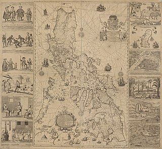
The Philippines is an archipelago that comprises 7,641 islands with a total land area of 300,000 square kilometers (115,831 sq mi). It is the world's fifth largest island country. The eleven largest islands contain 95% of the total land area. The largest of these islands is Luzon at about 105,000 square kilometers (40,541 sq mi). The next largest island is Mindanao at about 95,000 square kilometers (36,680 sq mi). The archipelago is around 800 kilometers (500 mi) from the Asian mainland and is located between Taiwan and Borneo.

Bohol, officially the Province of Bohol, is an island province of the Philippines located in the Central Visayas region, consisting of the island itself and 75 minor surrounding islands. Its capital is Tagbilaran. With a land area of 4,821 km2 (1,861 sq mi) and a coastline 261 km (162 mi) long, Bohol is the tenth largest island of the Philippines.

Siquijor, officially the Province of Siquijor, is an island province in the Philippines located in the Central Visayas region. Its capital is the municipality also named Siquijor. To the north of Siquijor is Cebu, to the west is Negros, northeast is Bohol, and to the south, across the Bohol Sea, is Mindanao.

Cebu Strait is a strait in the Central Visayas region in the Philippines.

Negros Oriental, officially the Province of Negros Oriental, is a province in the Philippines located in the Central Visayas region. Its capital is the city of Dumaguete. It occupies the southeastern half of the large island of Negros, and borders Negros Occidental, which comprises the northwestern half. It also includes Apo Island, a popular dive site for both local and foreign tourists.

Tagbilaran, officially the City of Tagbilaran, is a 3rd class component city and capital of the province of Bohol, Philippines. According to the 2020 census, it has a population of 104,976 people.

Larena, officially the Municipality of Larena, is a 5th class municipality in the province of Siquijor, Philippines. According to the 2020 census, it has a population of 14,454 people.

Loon, officially the Municipality of Loon, is a 2nd class municipality in the province of Bohol, Philippines which was established in 1753. According to the 2020 census, it has a population of 44,224 people.
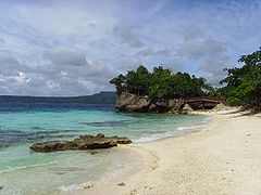
Panglao, officially the Municipality of Panglao, is a 4th class municipality in the province of Bohol, Philippines. According to the 2020 census, it has a population of 39,839 people.

Talibon, officially the Municipality of Talibon, is a 1st class municipality in the province of Bohol, Philippines. According to the 2020 census, it has a population of 71,272 people.

Tubigon, officially the Municipality of Tubigon, is a 1st class municipality in the province of Bohol, Philippines. According to the 2020 census, it has a population of 47,886 people.
Datu Sikatuna was a Datu or chieftain of the Bool Kingdom in the island of Bohol in the Philippines. He made a blood compact (sanduguan) and alliance with the Spanish explorer Miguel López de Legazpi on March 25, 1565 at Hinawanan Bay, barangay Hinawanan, Loay. Their blood compact is the first Treaty of Friendship between Spain and the Philippines. The previous site of the pact was thought to have been at barangay Bool, Tagbilaran City but later a panel of historians concluded that the event actually happened at barangay Hinawanan, Loay, Bohol as ratified through Resolution No. 4, issued by the National Historical Institute in 2005.
The Legazpi-Sikatuna Blood Compact or Sandugo was a blood compact, performed in the island of Bohol in the Philippines, between the Spanish explorer Miguel López de Legazpi and Datu Sikatuna the chieftain of Bohol on March 16, 1565, to seal their friendship as part of the tribal tradition. This is considered as the first treaty of friendship between the Spaniards and Filipinos. "Sandugo" is a Visayan word which means "one blood".

Banat-i is a hill located in Bool, Tagbilaran City. This hill commands a scenic view overlooking the vast Bohol Sea, Islands of Mindanao, Negros and Siquijor and the strait of Panglao Island. Elevation is 146 meters above sea level.

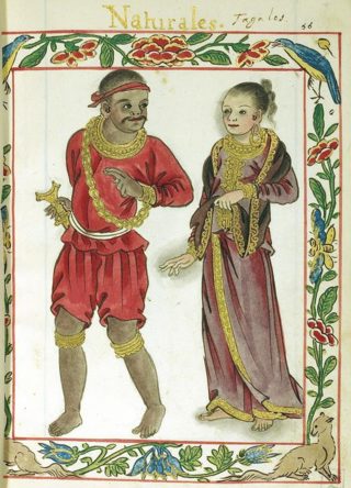
The Boholano people, also called Bol-anon, refers to the people who live in the island province of Bohol. They are part of the wider Bisaya ethnolinguistic group, who constitute the largest Filipino ethnolinguistic group.
Fil-Asian Airways, formerly Mid-Sea Express, was a Cebu-based airline with AOC issued by CAAP. It was formed in 2011 and ceased operating in 2014. Mid-Sea Express started as air charter operator and non-scheduled air taxi headquartered at Mactan–Cebu International Airport in Lapu-Lapu City in Central Visayas, in the Philippines. As Fil-Asian Airways, its slogan was "The Asian experience". The airline was operated from major airports such as Mactan–Cebu International Airport in Cebu, Francisco Bangoy International Airport in Davao City and Zamboanga International Airport.

The 2013 Bohol earthquake occurred on October 15 at in Bohol, an island province located in Central Visayas, Philippines. The magnitude of the earthquake was recorded at 7.2, with epicenter 6 kilometres (3.7 mi) S 24° W of Sagbayan, and its depth of focus was 12 kilometres (7.5 mi). It affected the whole Central Visayas region, particularly Bohol and Cebu. The earthquake was felt in the whole Visayas area and as far as Masbate island in the north and Cotabato provinces in southern Mindanao.

Central Visayas is an administrative region in the Philippines, numerically designated as Region VII. It consists of four provinces: and three highly urbanized cities: Cebu City, Lapu-Lapu, and Mandaue).

OceanJet Fast Ferries, Inc. is a wholly owned Filipino corporation that operates high-speed crafts commonly known as OceanJet, serving destinations in the Visayas, Luzon region in the Philippines.
Dapitan Kingdom is the term used by local historians of Bohol, Philippines, to refer to the Dauis–Mansasa polity in the modern city of Tagbilaran and the adjecent island of Panglao. The volume of artifacts unearthed in the sites of Dauis and Mansasa may have inspired the creation of the legend of the "Dapitan Kingdom" through piecing together the oral legends of the Eskaya people and historical events such as the Ternatan raid of Bohol and the migration of Boholanos under Datu Pagbuaya to Dapitan.