The Philippines is an archipelago that comprises 7,641 islands with a total land area of 300,000 square kilometers (115,831 sq mi). It is the world's fifth largest island country. The eleven largest islands contain 95% of the total land area. The largest of these islands is Luzon at about 105,000 square kilometers (40,541 sq mi). The next largest island is Mindanao at about 95,000 square kilometers (36,680 sq mi). The archipelago is around 800 kilometers (500 mi) from the Asian mainland and is located between Taiwan and Borneo.

The Strait of Malacca is a narrow stretch of water, 500 mi long and from 40 to 155 mi wide, between the Malay Peninsula to the northeast and the Indonesian island of Sumatra to the southwest, connecting the Andaman Sea and the South China Sea. As the main shipping channel between the Indian and Pacific oceans, it is one of the most important shipping lanes in the world. It is named after the Malacca Sultanate that ruled over the strait between 1400 and 1511, the center of administration of which was located in the modern-day state of Malacca, Malaysia.
The Luzon Strait is the strait between Taiwan and Luzon island of the Philippines. The strait thereby connects the Philippine Sea to the South China Sea in the western Pacific Ocean.

Leyte Gulf is a gulf in the Eastern Visayan region in the Philippines. The bay is part of the Philippine Sea of the Pacific Ocean, and is bounded by two islands; Samar in the north and Leyte in the west. On the south of the bay is Mindanao Island, separated from Leyte by the Surigao Strait. Dinagat Island partly encloses the gulf to the southeast, and the small Homonhon Island and Suluan Island, sit astride the eastern entrance to the Gulf. It is approximately 130 km (81 mi) north-south, and 60 km (37 mi) east-west.
Canigao Channel is a strait in the Central Visayan and Eastern Visayan regions in the Philippines. This strait separates the islands of Bohol and Leyte, while the Cebu Strait separates Bohol and Cebu. Thus, the Camotes Sea is connected to the Bohol Sea both by the Canigao Channel and Cebu Strait.

Cebu Strait is a strait in the Central Visayas region in the Philippines.
The Bohol Sea, also called the Mindanao Sea, is located between the Visayas and Mindanao islands in the Philippines. It lies south of Bohol and Leyte and north of Mindanao. Siquijor and Camiguin are its two major islands.

The Torres Strait, also known as Zenadh Kes, is a strait between Australia and the Melanesian island of New Guinea. It is 151 km (94 mi) wide at its narrowest extent. To the south is Cape York Peninsula, the northernmost extremity of the Australian mainland. To the north is the Western Province of Papua New Guinea. It is named after the Spanish navigator Luís Vaz de Torres, who sailed through the strait in 1606.

The Sibuyan Sea is a small sea in the Philippines that separates the Visayas from the northern Philippine island of Luzon.

The Visayan Sea is a sea in the Philippines surrounded by the islands of the Visayas. It is bounded by the islands Masbate to the north, Panay to the west, Leyte to the east, and Cebu and Negros to the south.
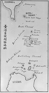
The Bashi Channel is a waterway between Y'Ami Island of the Philippines and Orchid Island of Taiwan. It is a part of the Luzon Strait in the Pacific Ocean. It is characterized by windy storms during the rainy period, June to December.

Caramoran, officially the Municipality of Caramoran, is a 3rd class municipality in the province of Catanduanes, Philippines. According to the 2020 census, it has a population of 32,114 people.

Caramoan, officially the Municipality of Caramoan, is a 2nd class municipality in the province of Camarines Sur, Philippines. According to the 2020 census, it has a population of 51,728 people.
The Balintang Channel is the small waterway that separates the Batanes and Babuyan Islands, both of which belong to the Philippines, in the Luzon Strait.

The Camotes Sea is a small sea within the Philippine archipelago, situated between the Central Visayan and the Eastern Visayan regions. It separates Cebu from Leyte hence is bordered by Cebu to the west, Leyte to the east and north, and Bohol to the south. At its center are the Camotes Islands, but it also contains Mactan Island, Olango Island, Lapinig Island, and various other small islets.

Apo Reef is a coral reef system in the Philippines situated in the western waters of Occidental Mindoro province in the Mindoro Strait. Encompassing 34 square kilometres (13 sq mi), it is considered the world's second-largest contiguous coral reef system, and is the largest in the country. The reef and its surrounding waters are protected areas administered as the Apo Reef Natural Park (ARNP). It is one of the best known and most popular diving regions in the country, and is in the tentative list for UNESCO World Heritage Sites.
"Filipino Monkey" is a taunt used by radio pranksters in maritime radio transmissions since at least the 1980s, especially in the Persian Gulf. This taunt is also used as a name for pranksters who make odd, confusing, or even threatening calls on VHF marine channel 16, which is the VHF calling and distress channel. Ships at sea are required to monitor the channel, which is meant to be used only to make contact before changing to a working channel.

Nueva Camarines is a proposed province of the Philippines to be created out of Camarines Sur in the Bicol Region of the island of Luzon. The proposed province would border Camarines Sur to the west, the Philippine Sea to the north, Albay to the south, and to the east the island province of Catanduanes across Maqueda Channel. Its capital is expected to be Tigaon if the bill is passed.