The Battle of Leyte Gulf 23–26 October 1944, was the largest naval battle of World War II and by some criteria the largest naval battle in history, with over 200,000 naval personnel involved.
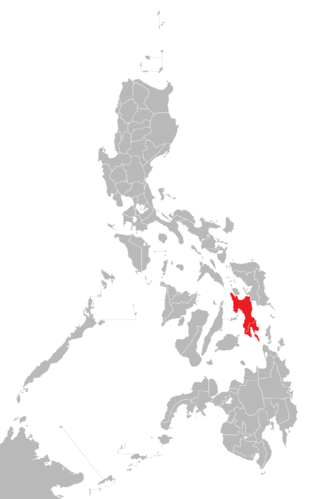
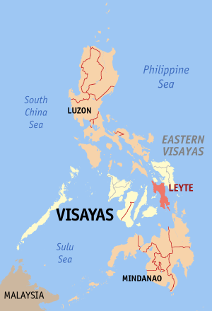
Leyte is an island in the Visayas group of islands in the Philippines. It is eighth-largest and sixth-most populous island in the Philippines, with a total population of 2,626,970 as of 2020 census.

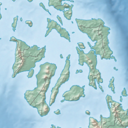
Leyte Gulf, also known simply as the Leyte, is a gulf in the Eastern Visayan region in the Philippines. The bay is part of the Philippine Sea of the Pacific Ocean, and is bounded by two islands; Samar in the north and Leyte in the west. On the south of the bay is Mindanao Island, separated from Leyte by the Surigao Strait. Dinagat Island partly encloses the gulf to the southeast, and the small Homonhon Island and Suluan Island, sit astride the eastern entrance to the Gulf. It is approximately 130 km (81 mi) north-south, and 60 km (37 mi) east-west.

Northern Samar, officially the Province of Northern Samar, is a province in the Philippines located in the Eastern Visayas region. Its capital is Catarman, the most populous town in the province and is located at the northern portion of the island of Samar. Bordering the province to the south are the provinces of Samar and Eastern Samar. To the northwest, across the San Bernardino Strait is Sorsogon; to the east is the Philippine Sea of the Pacific Ocean and to the west is Samar Sea.

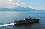
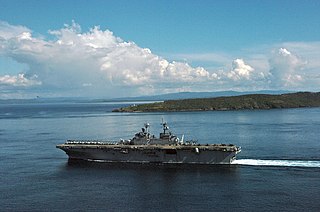
USS Gambier Bay (CVE-73) was a Casablanca-class escort carrier of the United States Navy. During the Battle off Samar, part of the overall Battle of Leyte Gulf, during a successful effort to turn back a much larger attacking Japanese surface force, Gambier Bay was sunk by naval gunfire, primarily from the battleship Yamato, taking at least 15 hits between 8:10 and 8:40. She was the only American aircraft carrier sunk by enemy surface gunfire during World War II.

Samar is the third-largest and seventh-most populous island in the Philippines, with a total population of 1,909,537 as of the 2020 census. It is located in the eastern Visayas, which are in the central Philippines. The island is divided into three provinces: Samar, Northern Samar, and Eastern Samar. These three provinces, along with the provinces on the nearby islands of Leyte and Biliran, are part of the Eastern Visayas region.

San Juanico Strait is a narrow strait in the Eastern Visayan region in the Philippines. It separates the islands of Samar and Leyte and connects Carigara Bay with the San Pedro Bay. It is about 38 kilometres (24 mi) long. At its narrowest point, the strait is only 2 kilometers (1.2 mi) wide.

USS White Plains (CVE-66) was a Casablanca-class escort carrier of the United States Navy. She was named after the 1776 Battle of White Plains.

Takeo Kurita was a vice admiral in the Imperial Japanese Navy (IJN) during World War II. Kurita commanded IJN 2nd Fleet, the main Japanese attack force during the Battle of Leyte Gulf, the largest naval battle in history.
Battle of the Philippines may refer to several wars, military campaigns, and major battles which have been fought in the Philippine Islands, including:
Capul, officially the Municipality of Capul, is a 5th class island municipality in the province of Northern Samar, Philippines. According to the 2020 census, it has a population of 12,323 people.

San Antonio, officially the Municipality of San Antonio, is a 5th class municipality in the province of Northern Samar, Philippines. According to the 2020 census, it has a population of 8,882 people.

Guiuan, officially the Municipality of Guiuan, is a 2nd class municipality in the province of Eastern Samar, Philippines. It constitutes the southeastern extremity of Samar Island and some adjacent islands, surrounded by Leyte Gulf and the Philippine Sea, two major bodies of water that makes the town the surfing capital of the Visayas. According to the 2020 census, it has a population of 53,361 people, making it the most populous municipality in Eastern Samar and the second most populous administrative division in the entire province after the capital city Borongan.
San Isidro, officially the Municipality of San Isidro, is a 4th class municipality in the province of Leyte, Philippines. According to the 2020 census, it has a population of 30,722 people.

The Samar Sea is a small sea within the Philippine archipelago, situated between the Bicol Region of Luzon and the Eastern Visayas.
Batag Island Lighthouse is a historic lighthouse on Batag Island off the coast of the town of Laoang in the province of Northern Samar in the Philippines. The light marks the northeastern point of Samar Island and led international ships to the entrance of the San Bernardino Strait marked by the San Bernardino Light. One of the most traveled waterways in the archipelago, together with the Capul Island Light, these stations are invaluable to vessels coming from the Pacific Ocean and entering the country through the San Bernardino Strait on its way to Manila or any other ports of the Philippines.

Capul Island Lighthouse is a historic lighthouse on Titoog Point in San Luis on the northern tip of Capul Island, Northern Samar in the Philippines. It marks the western entrance to the San Bernardino Strait coming in from Ticao Pass.
Eastern Visayas is an administrative region in the Philippines, designated as Region VIII. It consists of three main islands: Samar, Leyte, and Biliran. The region has six provinces: Biliran, Leyte, Northern Samar, Samar, Eastern Samar, Southern Leyte, one independent city, Ormoc, and one highly urbanized city, Tacloban. The highly urbanized city of Tacloban is the sole regional center. These provinces and cities occupy the easternmost islands of the Visayas group of islands, hence the region's name. Some historians believe that the oldest ancient kingdom in the Philippines is found in this region, the Lakanate of Lawan, which plays a significant role in the Polynesian and Austronesian intermigration.
Leyte–Samar Naval Base was a large United States Navy base in the Philippines on the Islands of Leyte, Samar and the San Pedro Bay. The base was built during World War II to support the many naval ships fighting and patrolling in the South West Pacific theatre of war as part of the Pacific War. A number of naval facilities were built on the east coast of Leyte island starting October 20, 1944. The first base was built at between the city of Tacloban and Anibong Point, a mile north of the city. Headquarters for the Seventh Fleet was built at Tolosa, 10 miles south of Tacloban on Leyte. The bases were on the large San Pedro Bay in Leyte Gulf which provided safe anchorage for many ships. Due to the lack of dry ground in Tacloban a second base was built on the east side of Leyte Gulf, on the south tip of Samar, on Calicoan Island and Tubabao Island. At Samar, a large Naval Depot was built to support the Pacific War. Samar was about 50 miles across Leyte Gulf from Tacloban. All construction was done by the Navy's Seabees.