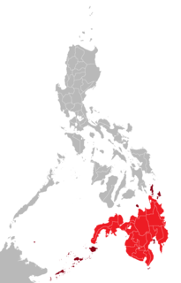
The Philippines is an archipelago that comprises over 7,000 islands with a total land area of 300,000 square kilometers (115,831 sq mi). The 11 largest islands contain 95% of the total land area. The largest of these islands is Luzon at about 105,000 square kilometers (40,541 sq mi). The next largest island is Mindanao at about 95,000 square kilometers (36,680 sq mi). The archipelago is around 800 kilometers (500 mi) from the Asian mainland and is located between Taiwan and Borneo.

The Sulu Sea is a body of water in the southwestern area of the Philippines, separated from the South China Sea in the northwest by Palawan and from the Celebes Sea in the southeast by the Sulu Archipelago. Borneo is found to the southwest and Visayas to the northeast.

Isabela, officially the City of Isabela or simply known as Isabela City, is a 4th class city in Basilan, Philippines. According to the 2015 census, it has a population of 112,788 people.

Khadaffy Abubakar Janjalani was the nominal leader of the Moro militant group known as Abu Sayyaf and the leader of one of its factions.
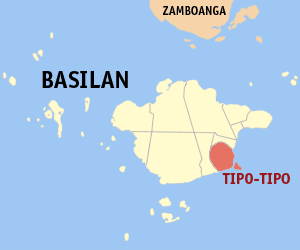
Tipo-Tipo, officially the Municipality of Tipo-Tipo,, is a 3rd class municipality in the province of Basilan, Philippines. According to the 2015 census, it has a population of 19,163 people.
The Legislative district of Basilan is the representation of the province of Basilan in the various national legislatures of the Philippines. The province is currently represented in the lower house of the Congress of the Philippines through its lone congressional district.
Basilan State College is a state college in the island province of Basilan. Its main campus is located in Isabela City with three college extensions in Lamitan City, Maluso and Tipo-Tipo, Basilan, plus one agricultural and secondary campus in Sta. Clara.

USS Basilan (AG-68/ARG-12) was a Basilan-class miscellaneous auxiliary acquired by the U.S. Navy during World War II. The ship was designed as a combined barracks-stores-water distillation ship, but was later converted to an electronics repair ship. She spent her Navy career in the Pacific Ocean theatre of operations.
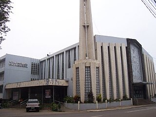
The Territorial Prelature of Isabela is a Roman Catholic territorial prelature located in the province of Basilan, and its component cities of Isabela City and Lamitan City, in the Ecclesiastical province of Zamboanga in the Philippines.
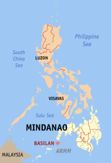
Basilan is an island province of the Philippines. It is the largest and northernmost of the major islands of the Sulu Archipelago and is located just off the southern coast of Zamboanga Peninsula. Its capital is Lamitan. Basilan is home to three main ethnic groups, the indigenous Yakans, and the later-arriving Tausugs and Chavacanos. The Yakans and Tausugs are predominantly Muslim, while the Chavacanos are mainly Christian. There are also a number of smaller groups.

Little Santa Cruz Island is an island situated 3.5 kilometres (2.2 mi) south of downtown Zamboanga City, on the Basilan Strait.
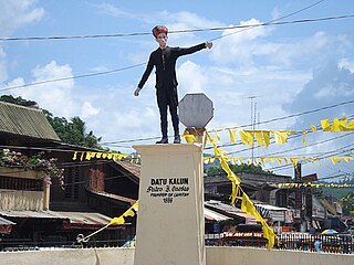
Lamitan, officially the City of Lamitan,, or simply known as Lamitan City, is a 6th class city and the capital of the province of Basilan, Philippines. According to the 2015 census, it has a population of 74,782 people.
The civil conflict in the Philippines as of February 2019, consists of an insurgency pitting Government forces against Maoist rebels, that began in 1969 during the rule of Ferdinand Marcos.
Battle of Basilan was a military offensive launched by the Philippine military to apprehend two lead commanders in the Abu Sayyaf Islamic militia wanted for corruption, money laundering, and terrorism related charges. The main cause of the operation was Sayyaf leader Indama and his followers threatening and attempting to extort money from a circumferential road network. The two-day offensive ended with the both suspects evading capture and the island of Basilan falling under government authority. Both the army and MNLF collaborated in fighting alongside for a duration of the operation the first such instance since a truce. However collaborators within the Sayyaf militia included members of the MNLF who sympathized with their cause or had public relations with some of the militants.

The Sama language, Sinama, is the language of Sama-Bajau people of the Sulu Archipelago, Philippines; Sabah, Malaysia and parts of Indonesia. The Sama are one of the most widely dispersed peoples in Southeast Asia.

Basilan Steel is a professional basketball team in the Maharlika Pilipinas Basketball League (MPBL) based in Basilan.