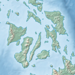
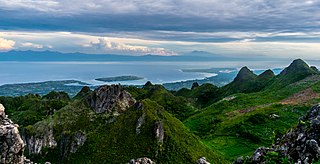
The Visayas, or the Visayan Islands, are one of the three principal geographical divisions of the Philippines, along with Luzon and Mindanao. Located in the central part of the archipelago, it consists of several islands, primarily surrounding the Visayan Sea, although the Visayas are also considered the northeast extremity of the entire Sulu Sea. Its inhabitants are predominantly the Visayan peoples.

Panay is the sixth-largest and fourth-most populous island in the Philippines, with a total land area of 12,011 km2 (4,637 sq mi) and has a total population of 4,542,926 as of 2020 census. Panay comprises 4.4 percent of the entire population of the country. The City of Iloilo is its largest settlement with a total population of 457,626 inhabitants as of 2020 census.

Negros Oriental, officially the Province of Negros Oriental, is a province in the Philippines located in the Central Visayas region. Its capital is the city of Dumaguete. It occupies the southeastern half of the large island of Negros, and borders Negros Occidental, which comprises the northwestern half. It also includes Apo Island, a popular dive site for both local and foreign tourists.
Panay Gulf is an extension of the Sulu Sea, reaching between the islands of Panay and Negros in the Philippines. The gulf contains the island-province of Guimaras and extends into the Iloilo Strait, between Panay and Guimaras, and into Guimaras Strait, between Guimaras and Negros. Guimaras Strait connects Panay Gulf with the Visayan Sea.

Iloilo, officially the Province of Iloilo, is a province in the Philippines located in the Western Visayas region. Its capital is the City of Iloilo, the regional center of Western Visayas. Iloilo occupies a major southeast portion of the Visayan island of Panay and is bordered by the province of Antique to the west, Capiz to the north, the Jintotolo Channel to the northeast, the Guimaras Strait to the east, and the Iloilo Strait and Panay Gulf to the southwest.

Capiz, officially the Province of Capiz, is a province in the Philippines located in the central section of Western Visayas region. Its capital is the city of Roxas. It is located at the northeastern portion of Panay Island, bordering Aklan to the north, Antique to the west, and Iloilo to the south. Capiz faces the Sibuyan Sea to the north.

Western Visayas is an administrative region in the Philippines, numerically designated as Region VI. It consists of six provinces and two highly urbanized cities. The regional center is Iloilo City. The region is dominated by the native speakers of four Visayan languages: Hiligaynon, Kinaray-a, Aklanon and Capiznon. The land area of the region is 20,794.18 km2 (8,028.68 sq mi), and with a population of 7,954,723 inhabitants, it is the second most populous region in the Visayas after Central Visayas.

Visayans or Visayan people are a Philippine ethnolinguistic group or metaethnicity native to the Visayas, the southernmost islands of Luzon and a significant portion of Mindanao. When taken as a single ethnic group, they are both the most numerous in the entire country at around 33.5 million, as well as the most geographically widespread. The Visayans broadly share a maritime culture with strong Roman Catholic traditions integrated into a precolonial indigenous core through centuries of interaction and migration mainly across the Visayan, Sibuyan, Camotes, Bohol and Sulu seas. In more inland or otherwise secluded areas, ancient animistic-polytheistic beliefs and traditions either were reinterpreted within a Roman Catholic framework or syncretized with the new religion. Visayans are generally speakers of one or more of the Bisayan languages, the most widely spoken being Cebuano, followed by Hiligaynon (Ilonggo) and Waray-Waray.

The Sibuyan Sea is a small sea in the Philippines that separates the Visayas from the northern Philippine island of Luzon.

Daanbantayan, officially the Municipality of Daanbantayan, is a 1st class municipality in the province of Cebu, Philippines. According to the 2020 census, it has a population of 93,502 people.

Moalboal, officially the Municipality of Moalboal, is a fourth class municipality in the province of Cebu, Philippines. According to the 2020 census, it has a population of 36,930.
Panay, officially the Municipality of Panay, is a 3rd class municipality in the province of Capiz, Philippines. According to the 2020 census, it has a population of 48,890 people.
Carles, officially the Municipality of Carles, is a 2nd class municipality in the province of Iloilo, Philippines. According to the 2020 census, it has a population of 72,637 people.

Estancia, officially the Municipality of Estancia, is a 2nd class municipality in the province of Iloilo, Philippines. According to the 2020 census, it has a population of 53,200 people.

The Camotes Sea is a small sea within the Philippine archipelago, situated between the Central Visayan and the Eastern Visayan regions. It separates Cebu from Leyte hence is bordered by Cebu to the west, Leyte to the east and north, and Bohol to the south. At its center are the Camotes Islands, but it also contains Mactan Island, Olango Island, Lapinig Island, and various other small islets.
The Tañon Strait is a body of water, separating the islands of Negros and Cebu in the Visayas, Philippines. The strait, which is about 160 kilometres (100 mi) long, connects the Visayan Sea in the north to the Bohol Sea in the south. Its width varies from 5 to 27 kilometres, with the narrowest point in the south. In the north the strait is closed off by the Don Islands, the largest of which is Bantayan. The cities of San Carlos, Negros Occidental, Bais, Negros Oriental and Toledo, Cebu have deepwater port facilities. The Tañon Strait is known for whale and dolphin watching, with tour boats operating from Bais.

Guimaras Strait is a strait in the Western Visayas region of the Philippines, connecting the Visayan Sea with Panay Gulf and the Sulu Sea beyond. To the north and west are Panay and Guimaras Islands, while Negros Island is to the south and east. Bacolod City is a major seaport on the strait, which also provides access to the Port of Iloilo City via the Iloilo Strait.
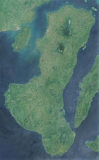
Negros is the fourth largest and third most populous island in the Philippines, with a total land area of 13,309 km2 (5,139 sq mi). Negros is one of the many islands of the Visayas, in the central part of the country. The predominant inhabitants of the island region are mainly called Negrenses. As of 2020 census, the total population of Negros is 4,656,945 people.

Central Visayas is an administrative region in the Philippines, numerically designated as Region VII. It consists of four provinces: and three highly urbanized cities: Cebu City, Lapu-Lapu, and Mandaue).
The Iloilo–Guimaras–Negros–Cebu Link Bridge is a planned network of bridges in the Visayas in the Philippines connecting the islands of Panay, Guimaras, Negros, and Cebu.