This article deals with the diplomatic affairs, foreign policy and international relations of the Argentine Republic. At the political level, these matters are handled by the Ministry of Foreign Affairs, also known as the Cancillería, which answers to the President. The current Minister of Foreign Affairs, since December 2023, is Chancellor Diana Mondino.

An exclusive economic zone (EEZ), as prescribed by the 1982 United Nations Convention on the Law of the Sea, is an area of the sea in which a sovereign state has exclusive rights regarding the exploration and use of marine resources, including energy production from water and wind.

Isla Salas y Gómez, also known as Isla Sala y Gómez, is a small uninhabited Chilean island in the Pacific Ocean. It is sometimes considered the easternmost point in the Polynesian Triangle.

Argentine Antarctica is an area on Antarctica claimed by Argentina as part of its national territory. It consists of the Antarctic Peninsula and a triangular section extending to the South Pole, delimited by the 25° West and 74° West meridians and the 60° South parallel. This region overlaps with British and Chilean claims in Antarctica. None of these claims have widespread international recognition.

The Chilean Antarctic Territory, or Chilean Antarctica, is a part of West Antarctica and nearby islands claimed by Chile. It comprises the region south of 60°S latitude and between longitudes 53°W and 90°W, partially overlapping the Antarctic claims of Argentina and the United Kingdom. It constitutes the Antártica commune of Chile.

International relations between the Republic of Chile and the Argentine Republic have existed for decades. The border between the two countries is the world's third-longest international border, which is 5,300 km (3,300 mi) long and runs from north to south along the Andes mountains. Although both countries gained their independence during the South American wars of liberation, during much of the 19th and the 20th century, relations between the countries were tense as a result of disputes over the border in Patagonia. Despite this, Chile and Argentina have never been engaged in a war with each other. In recent years, relations have improved. Argentina and Chile have followed quite different economic policies. Chile has signed free trade agreements with countries such as China, the United States, Canada, South Korea, as well as European Union, and it's a member of the APEC. Argentina belongs to the Mercosur regional free trade area. In April 2018, both countries suspended their membership from the UNASUR.

The Argentine Sea is a marginal sea of the Atlantic Ocean adjacent to the southern tip of South America. It ranges from the mouth of the estuary of the Río de la Plata in the north to the Isla de los Estados in the south, and from the Argentine coast to the 200 meters isobath. Its width varies between 210 km in front of Mar del Plata and 850 km at the latitude of the Falkland Islands. The coastline extends for 4,725 km. To the east of the Argentine Sea extends much deeper and more extensive Argentine Basin.

Portugal has the 5th largest exclusive economic zone (EEZ) within Europe, 3rd largest of the EU and the 20th largest EEZ in the world, at 1,727,408 km2.

The Treaty of Peace and Friendship of 1984 between Chile and Argentina was signed into agreement at the Vatican on 29 November 1984.

Tricontinental Chile is a geopolitical concept denoting Chile's unique position with its mainland in South America, Easter Island in Oceania (Polynesia) and the Chilean Antarctic Territory in Antarctica. This concept is built on the basis that there are Chilean territories as far away from the mainland as to be considered part of Polynesia and on a larger scale, Oceania, and Chile's claims to Antarctica provide it a basis for claiming to be a part of Antarctica as well.

The Argentina–Chile border is the longest international border of South America and the third longest in the world after the Canada–United States border and the Kazakhstan–Russia border. With a length of 5,308 kilometres (3,298 mi), it separates Argentina from Chile along the Andes and on the islands of Tierra del Fuego. However, there are some border disputes, particularly around the Southern Patagonian Ice Field. It is the largest border of the two countries, beating the Argentina–Paraguay and Chile–Bolivia, Argentina's and Chile's second largest borders, respectively.

Insular Chile, also called Las islas Esporádicas, or "the Sporadic Islands", is a scattered group of oceanic islands of volcanic origin located in the South Pacific, and which are under the sovereignty of Chile. The islands lie on the Nazca Plate, separate from the South American continental plate.

Chilean expansionism refers to the foreign policy of Chile to expand its territorial control over key strategic locations and economic resources as a means to ensure its national security and assert its power in South America. Chile's significant territorial acquisitions, which occurred mostly throughout the 19th century, paved the way for its emergence as a thalassocracy and one of the three most powerful and wealthiest states in South America during the 20th century. It also formed Chile's geopolitical and national identity as a tricontinental state and one of the countries with the longest coastlines in the world.
Spain's exclusive economic zone (EEZ) is the 30th largest in the world with 1,039,233 km2 (401,250 sq mi). It is mostly in the Atlantic Ocean and the Mediterranean Sea. This is approximately double the entire Spanish land area. Together the land and sea surface would account for approximately 0.3% of the world's land surface.

The natural delimitation between the Pacific and South Atlantic Oceans by the Scotia arc is a hydrographical concept developed in Chile in 1952 in which it was postulated that the boundary between the southeast Pacific Ocean and the southwest Atlantic Ocean should not be the meridian of Cape Horn but rather follow the line of the Scotia Arc, an underwater mountain range which links the Tierra del Fuego archipelago with the Antarctic continent.

A presential sea, zone of maritime presence or heritage marine reserve is a zone of influence demarcated by a maritime country in the high seas adjacent to its exclusive economic zone (EEZ). The objective of this oceanopolitical concept or doctrine, is to signal to third parties where the coastal country's interests are, or could be directly involved.
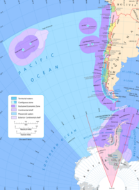
The extended continental shelf, scientific continental shelf, or outer continental shelf, refers to a type of maritime area, established as a geo-legal paradigm by the United Nations Convention on the Law of the Sea (UNCLOS). Through the process known as the extension of the outer limit of the continental shelf or establishment of the outer edge of the continental margin, every coastal state has the privilege, granted by the international community of nations, to acquire exclusive and perpetual rights to exploit the biotic and abiotic resources found on the seabed and subsoil of these maritime areas. These areas are located beyond the 200 nautical miles that make up the state's exclusive economic zone (EEZ) and would otherwise be considered international waters.

The dispute over the extended continental shelf in the Southern Zone Sea between Argentina and Chile is a disagreement between the two countries over a maritime area of 5,302 km² that began after Argentina attempted to extend its maritime space based on the theory of the extended continental shelf over the Southern Zone Sea, south of Point F as agreed in the 1984 treaty, in an area claimed by Chile as part of its "presential sea", and now as part of its continental shelf projected from the Diego Ramírez Islands.

The Sea of the Southern Zone or Southern Zone Sea is the name given by Argentina and Chile to the maritime area whose boundaries were undefined, located south of the Isla Grande de Tierra del Fuego. This maritime space was subject to delimitation in the Treaty of Peace and Friendship of 1984 between Chile and Argentina, which ended the Beagle conflict or "Southern Zone conflict."
The continental shelf of Chile refers to the underwater extension adjacent to the Chilean coasts that stretches from the shoreline to the edge of the continental shelf in the Pacific Ocean and the Southern Ocean.